
The concept of the "other" as a feature in the cultural encounter between West and East has, perhaps, been overemphasized in contemporary accounts. At a period considerably prior to the Discoveries, a composite culture had already emerged in the Iberian Peninsula in which the Islamic component could not be ignored. It was through the Norman occupation of Sicily that an intermingling had taken place between Islamic maritime tradition and that of Christianity, and it was here that the introduction to Arab nautical and geographical knowledge occurred. 1
The structure on which Portuguese navigation developed during the period of the Discoveries was that of the network of practices supported by the web of instrumentation which had been developed in response to the needs of Mediterranean sailing. To a knowledge of tidal timings2 was added, through Arab intervention, the magnetic needle. 3 Around A. D. 1200 under the influence of the sailors of Amalfi, an innovation was introduced - the magnetized needle was placed on a wind rose of thirty-two rhumbs. 4 Sea rutters in the form of Portolan charts were used for navigating on course in conjunction with ancillaries to serve the needs of dead reckoning. With regard to the genesis of the Portolan chart, A. Cortesão and de Albuquerque have conflicting views. The former traces it back to charts of Marinus of Tyre while the latter maintains that it was an empirical solution to immediate seafaring problems5 evolved at a time when the additional instrumentation provided through the compass could be brought into use.
Portolan charts did not have parallels and meridians. The coastline was, after the fifteenth century, 6 indicated by thirty-two magnetic rhumb lines. The navigator would chart out his course with the help of a compass. The chart would have central and peripheral roses, each having its own set of distance-measuring rules. 7 While navigating its course, the ship could deviate from the set course because of currents or exigencies of tacking. The Toleta de Marteloio, dated to between A. D. 1286-1295 by Taylor, and the sixteenth century by de Albuquerque (Taylor, 1971, 117-118; de Albuquerque, 1988a, 82-83.), provided tables with the help of which such deviations could be corrected. With the top of the chart facing east, for each quarter of wind direction the chart would show deviations for a trajectory of one hundred miles in relation to rhumb lines. (J. Cortesão, 1975, 294; Taylor, 1971, 117-121, de Albuquerque, 1988a, 80-85.) With the development of Atlantic navigation a greater degree of accuracy became necessary.
The Canary Islands were discovered in A. D. 1336 and the island of Madeira along with a few of the Azores Islands appeared for the first time in a map by Dalorto in A. D. 1339. The return voyage posed problems as dead reckoning with the help of a compass was not a satisfactory solution. (A. Cortesão, 1966, 57-58). It became necessary to extend Ptolemaic processes to navigation and to the new geographical knowledge, bringing this into relation with the celestial sphere so that the latitude and longitude of any position on land or sea could be determined. 8 The process of latitude sailing on the basis of stellar position fixing was accelerated after the line of the equator had been crossed on the African coast. In the period 1480-1485, nautical charts began to show parallels of latitude in addition to rhumb lines. This was done by comparing altitudes taken on land with those taken at sea. 9
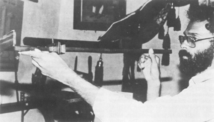
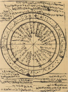 Sidereal azimmuthal compass. From a manuscript collection now in National Museum, New Delhi. It is dated A. D. 1780.
By the time the Portuguese rounded the Cape of Good Hope, they had evolved an array of methodological and technological devices as a result of which they were quickly and easily able to take full advantage of the Indian Ocean and South China Sea traditions of position finding on the high seas. From the beginning, the Portuguese were aware of the fact that a newly discovered land would cease to have any relevance unless this was accompanied by a simultaneous opening of systematic channels of communication. The problem thus addressed was articulated at a conceptual level rather than on a political plane. Efforts at the theoretical level were coordinated with practical efforts and pilots were instructed to comprehend and practice these new formulae. Hence the practice of Saber de experiências feito (empirically tested knowledge) was essential for the pilot to understand, in a general way, the functioning of what, in its totality, came to be called the máquina do mundo (J. Cortesão, 1976, 1381).
The interest in astronomy had been expressed in the Libros del Saber de Astronomia, a compendium of existing cosmographical and astronomical knowledge of the times, framed at Toledo in the thirteenth century at the instance of King Afonso X of Castille. A copy was in the possession of King Dinis of Portugal (1279-1325). In A. D. 1290 King Dinis founded the Estudo Geral, among the earliest European universities, at Lisbon. Nautical issues thus entered into university studies. This institution was shifted to Coimbra in 1307. With the activities of Prince Henry (1394-1460) the application of astronomy to navigational matters assumed greater importance. The School of Sagres came into being and here, nautical experts, native and foreign, tried to solve problems posed by new navigational attainments. Among them was the Catalan cartographer and instrument maker, Master Jacome of Majorca, who came between 1420-1427. D. João II (1481-1495) created the Junta of astronomers and mathematicians. Their work resulted in quadrennial solar tables; detailed instructions and rules for calculating latitude by the sun's meridional altitude by Ursa Minor and other stars; precise rules for plotting the ship's route including the Regiment of the Leagues. (A. Cortesão, 1974, 14, 160).
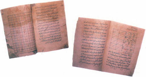
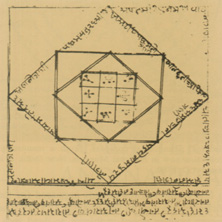 Astrological chart in a sailing manual. Dushyanta Pandya Collection, manuscript dated A. D. 1664, National Museum, New Delhi. This manuscript is a copy but bears the original colophon. This is a vogini chart, used for planning any journey. The first and ninth tithis (lunar days) were declared inauspicious.
The systematization went much further in the sixteenth century. The Regiment of the Altitude of the Pole at Noon provided tables for the determination of latitude by measurement of the sun at its maximum altitude. (Pereira da Silva, 1943, 419; de Albuquerque, 1988, 57-58.) In the northern hemisphere the fixing of latitude and time at night were accomplished through the Regiment of the North Star by observation of the Little Bear. (Pereira da Silva, 1943, 419; de Albuquerque, 1988, 29-57.) For the southern hemisphere the Southern Cross was used to mark time and calculate the latitude. The pilot, João de Lisboa, described the method of measurement of declination through the Southern Cross in his work, Tratado da agulha de marear, 1514. 10 Although, in effect, the Portuguese were also creating a sidereal compass, they were, at the same time creating other systems to make this usage more accurate. This element of continuous research activity is absent in Indian Ocean customary practices in which innovation has to be channelled within the parameters of existing tradition.
Despite these remarkable developments, Arab input into Portuguese nautical tradition should not be overlooked. The directional compass and the astrolabe which had been received through Arab mediation were adapted to serve specifically as nautical instruments by the Portuguese. Pedro Nunes (1502-1578) invented the 'Shadow Instrument'11, illustrated in his Tratado da Sphera published in Lisbon in 1537. It served to calculate magnetic variation with the approximation of half a degree and gave the azimuths of the sun when at equal altitudes before and after midday. This instrument admirably served the needs of dead reckoning. The thirty-two point azimuthal compass used by sailors was developed from Nunes'--'Shadow Instrument' of Nunes. The planispheric astrolabe introduced to Europe by the Arabs in around the tenth century A. D. was unsuitable for use at sea12 and, some time after A. D. 1480, the Portuguese adapted the existing model into the sea astrolabe. It remained in use until the mid-seventeenth century when it was replaced by the improved quadrant (National Maritime Museum, 1985, 42.)
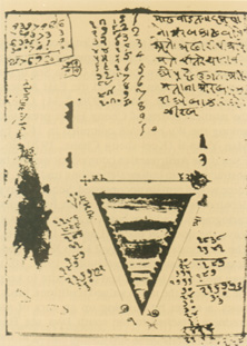 Diagram showing distance between Madhwad and Daman. Sailing manuscript dated A. D. 1779. Dushyanta Pandya Collection, at present in National Museum, New Delhi.
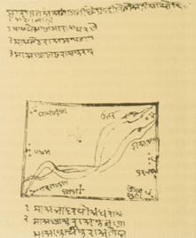 Depiction of Milky Way/Vatsa/Akash Ganga. Dushyanta, Pandya Collection, copy, colophon A. D. 1664, at present in Nacional Museum, New Delhi. This shows the position of the Milky way between May and October. The position of a ship at sea could be worked out on this basis.
What were the attainments of the mariners of the Indian Ocean to which the Portuguese were exposed after Vasco da Gama rounded the Cape of Good Hope and anchored at Melindi? This will be examined from the points of view of channels of communication by sea, instrumentation and map making. There will also be references to the living traditions of the Indian Union Territory of Lakshadweep and the Republic of the Maldives, as, in many ways existing usages in these regions mirror the range of expertise evolved in the past.
While it is difficult to date the beginnings of maritime activity in South Asia, its existence since remote times cannot be doubted. 13 P. Y. Manguin has written on the Southeast Asian component. The earliest archaeological evidence of Southeast Asian boat remains is dated A. D. 210-335. The Austronesian/Indonesian journeying by out-rigger boats to Madagascar between the third and sixth centuries A. D., 14 and references in Chinese and Arab texts to these migrants as Kouen Louen t'seng-k'i, and Zanj/Wak-wak15 respectively, show that the vagaries of the currents in the Mozambique Channel must have been known at that point in time. Since the network of pre-Portuguese commercial interests which had developed along the islamicized East African coast had no need to develop trade routes to South Asia from points as far south as the Cape of Good Hope, the evolution of navigational scales and tables in relation to Madagascar was redundant. (Moura Braz, 1962, 60-62.)
Moura Braz and Tibbetts deal at length with the routes described in Arab rutters or rahmani. The sustained Chinese interest in routes to the west are shown in several Chinese works. There was an overland route across the Mekong, Salween and down the Irrawaddy river to the Bay of Bengal dating to the Han period. The terminal points in India were Andhra Pradesh and Tamil Nadu. (Cody, 1976, 22; Julien, 1847, 99-102.) In the eighth century A. D., Kia Tan produced a detailed itinerary between China and Bengal (Pelliot, 1904, 142, 175-181) and in the period 1405-1433, Cheng Ho, at the behest of the Ming Emperor, directed seven expeditions visiting numerous countries stretching between the South China Sea in the east to the Persian Gulf and the East African Coast to the west. (Mills, 1970, 8-34). One of the nautical charts of Cheng Ho is preserved among the Wu-pei-chih compiled in 1621 by Mao Yuan-ti (Kuei-sheng Chang, 1970, 26.) Even if the Austronesian component were to be abstracted from Indonesian sailing tradition, its force would remain uncontested. Scholars have debated as to the existence of an Indonesian cartographic tradition but A. Lapian prefers to leave the question open. (Lapian, 1985, 1-6.) The Indonesian cult of Nyai Loro Kidul, goddess of the southern sea (Guillot, 1982, 102), may well have been linked to a desire to keep the source of the much valued traditions, birds' nests, a secret by building up an aura of sacredness attached to the south Java sea. This aura of mystery may have contributed to the confusion with regard to the configuration of the Indonesian archipelago which Tomé Pires, da Mota and Moura Braz have attributed to a faulty method of local charting (Suma, 336, da Mota, 1963, 71, 80-81; Moura Braz, 1962, 64.)
Unlike the uninterrupted expanse of water characteristic of the Atlantic crossing, the Indian Ocean was divided into segments, and each segment had built up its own area of expertise. Parallel to the Portuguese accomplishment at a later date, the Arabs synthesized much of the existing knowledge of the Indian Ocean, possibly ignoring Chinese input. To characterize Arab rahamani in terms of Arab ethnicity, even if taken in a broader sense, would, therefore, be a misnomer. 16 However, given the state of existing knowledge it is not possible to isolate individual inputs.
This corpus of knowledge continued to grow in the same manner as it had come into being. Sulaiman al Mahri provided the key to its constituents: empirical knowledge, intellectual investigations and oral testimony. In describing the qualities required of a navigator he says: Know that the basic qualities required by a navigator are intellect and much experience... Some things require the one and some the other. Thus knowing the routes (diyar) and following right seasons (mawasim) are matters for experience; but knowing the form of the stars in the heavens (taswir al-kawakib), the elements of calculation (gawa'id al-hisab), calculating longitude from the stars (ighzar wa irqaq) and similar things, are a matter for the intellect. Measuring latitude (giyasat) and distances (masafat) are matters of both intellect and experience. As for taking calculated bearings to reach fixed ports... the basis of these are latitude measurements and distances... The native is, therefore, the man to take out information from. But if the others are established in this science and the native obviously knows little, then the established man will be more accurate. (Tibbetts, 1971, 391.)
Arabic knowledge of the monsoons dates back to pre-Islamic times. (Aleem, 1967, 461.) Ibn Majid devoted separate chapters to the subject of the season for sailing to different ports and that of the monsoon. (Tibbetts, 1971, 225-238, 360-382.) The Southwest monsoon was called Ríh al-Kaws, and the prevailing winds, Ríh al-Dabúr; the terms for the Northeast monsoon and its prevailing winds were Ríh Azyab and Ríh al Saba. (Tibbetts, 1971, 364, 368.) Knowledge of the reversal of currents dates to the ninth century A. D. (Aleem, 1967, 459.)
Teixeira da Mota (1963, 51-52.) has summarized the factors which promoted the development of a particular system of navigation of the coasts of South Asia. Once perfected it could be easily applied to other neighbouring sectors within the same latitudes. This northwest corner of the Indian Ocean was situated in relatively low latitudes. In the tropical zone and more particularly at the equator, the north and south celestial poles17 merge with the north and south directions on the horizon. Directional points along the horizon can be assessed through a series of rising and setting stars as these celestial bodies describe arcs perpendicular to the horizon. Their azimuths are equal to their polar distances. (de Saussure, 1928, 94; Pereira da Silva, 1943, 419-423.) Such facts were known to Indian astronomers well before the advent of Islam. (Sen, 1971, 59-60, 63-68, 86-91.) Unlike European sailors who needed a constant point of reference such as the Pole Star for the northern hemisphere, against which other measurements of altitude were taken, Asian pilots could dispense with a single point of reference. (Moura Braz, 1962, 35.) However, when such a method was chosen, north of 6° N., the Pole Star was used; between 6° N and 6° S it was the Little Bear (in Arabic Farkadain) and south of 6° S the Great Bear (Na'ch) came into prominence. (da Mota, 1963, 56.) The Portuguese evolved a parallel strategy during their Atlantic voyaging but showed a greater awareness of the use which could be made of measuring the altitude of the sun at midday and of constituting the Southern Cross as a point of reference. (J. Cortesão, 1976, 1380-1381; Pereira da Silva, 1943, 425-429.) Ibn Majid referred to the science of stellar measurement as Qiyas. A number of stars were used. The measurements could be converted on the basis of Pole Star equivalents or they could remain as they were. (Tibbetts, 1969, 10-11.) Ibn Majid listed as many as seventy different ways for the measurement of qiyas. (Tibbetts, 1969, 325, 330-331.)
The importance of qiyas stemmed from the link between destinations having equal stellar altitudes and the kind of techniques and technologies evolved in Arab seafaring traditions. While the Portuguese took care to establish the linkage between latitude and stellar bearings when they "ran down the latitude", in Arab tradition, to conceptualize latitude in terms of port location was redundant. (de Albuquerque, Lopes Tavares, 1967, 16-18; Moura Braz, 1962, 59.) In the absence of any explicit usage of longitude, long distance east to west voyages, masafa, was prone to a number of difficulties. (Tibbetts, 1963, 354-359.)
Despite Arab contributions to the popularization of the magnetic compass in the Mediterranean and their refinement of the astrolabe, their most trusted aid in the navigation of the Indian Ocean was the sidereal azimuthal compass, admirably suited to local conditions. De Saussaure assigns it a pre-Islamic origin but states its point of origin is now known. (de Saussure, 1928,119.) India could well stake its claim but it could also be a composite regional creation. In this compass, directions were named after stars on constellations which, when rising, also coalesced with a particular area in which one wind system was prevalent. (J. Cortesão, 1976, 1371; Tibbetts, 1971, 121-156, 294-298.) Sixteen stars were chosen in a successive series in relation to Polar distances, which at their rising or setting positions defined the horizon in thirty-two rhumbs. This appears to have been in use after the tenth century A. D. (da Mota, 1965, 52.) In the case of Gujarat and Lakshadweep, similar compasses, modified to suit local needs and objectives, have been found. (Arunachalam, 1987, 195-201; R. N. Mehta, 1979, 209-211.) However, particularly in Lakshadweep, there is clearly an amalgam with earlier traditions of Hindu astronomy. In Lakshadweep the thirty-two points of compass directions are associated both with constellations bearing Arabic nomenclature as well as with yogataras, associated with Hindu astronomy. 18 Experienced navigators today use a maximum of two or three stars on any one night. In Lakshadweep as also on the Kerala coast these guiding stars are called nakshatratte lakshyamakki tuliyal. Winds are named after both rising and setting asterisms as well as important place names of points in the direction from which they blow. (Arunachalam, 1990, 55, 121; Arunachalam, 1990a, 13n. 12). Evidence from Gujarat and Lakshadweep suggest that this sidereal azimuthal compass was expressed only in chart form.
 Navigation manuals. Office of the Collectorate, Kavaratti, Lakshadweep.
In plotting navigational routes Arab rahmani refer to units of angular distance in terms of isba, and linear measurement as zam. The Portuguese referred to the isba as polegada19 Cubit measurements appeared to have been transferred as lance. 20
Since the entire population of Lakshadweep is Muslim, it might be expected that Arab nautical traditions would prevail. In fact, seafaring traditions carry both an Islamic imprint and a Hindu layer derived from Kerala, the ethnic composition of Lakshadweep being very closely linked to that of Kerala. As such, it is possible to disentwine the Hindu from the Islamic strands. The implications of such a process of 'deconstruction' could also be brought to bear on repositories of nautical information dated to an earlier period.
Apart from zam there is the Tamil term naligai, corresponding to the Sanskrit ghatika. The tables were: 1 naligai = 24 minutes; 60 naligai = 1 day, 1 zam =7.5 naligai. At the same time the isba can be equally taken as viral (finger) equal to 3/4". The dubban, equivalent to four isbas, is equal to the four knuckles of a closed fist, equal to four virals. In diagonal sailings between latitudes leading to the raising or lowering of the altitude of the Pole or any other guiding star, the fact that there were decreasing dimensions in circles of latitude, gave rise to calculations of tirfat. (See Tibbetts; 1971,301; de Saussure, 1928a, 171,173-175.) In Lakshadweep such tables are called anavetti kanakku, a corruption of the phrase anayaagala (to move closer or further). (Arunachalam, 1990, 49-50, 94, 116n. 3; de Saussure, 1928a, 173; Tibbetts, 1971, 301.)
Wind and weather conditions for sailing were codified in the form of Kol Nila Shastram, for currents and drifts as Neer Nila, and for long distance voyages they were computed in terms of distance/time. The relevant table was called Idai-Yama-Kanakku. The subject matter for Karavalasa was constituted by a synthesis of stellar bearings, time-distance, topographic details and a broad coastal orientation of western India which formed the destination for most island voyages. (Arunachalam, 1990, 117,120-121, 155n.19.)
 Goi-daruvan (Divehi spoken in Maldives), balishti - Arabic, balestilha -- Portuguese, cross staff. National Museum, Malé.
The two most important instruments used in Arab navigation were the kamal and the cross staff called balestilha21 by the Portuguese. The Portuguese provided an 'Indian' association with the first and a 'Moorish' one for the latter. (Pereira da Silva, 1946, 31-32; De Albuquerque, Lopes Tavares, 1967, 13.) The two instruments were inter-related. The advantage of the kamal was that it was easier to transport and could measure longer units in angular height, but against this, the readings taken on the balestilha were rated as more accurate. (Pereira da Silva, 1943, 32-34.) Readings taken by kamal in the Sea of Oman were incorporated as the "Regiment of the Arab Arbalestrille" in the Livro de Marinharia by André Pires, C. 1550. (da Mota, 1963,68-69.) The balestilha was introduced to Portugal by Vasco da Gama. Contradicting Maddison, de Albuquerque clarifies that the balestilha (cross staff) is not to be confused with the Jacob staff mentioned by the Catalan Jew, Levi Ben Gerson (1288-1344) in the work Sefer tekunan. Pedro Nunes unconsciously testified to Indian Ocean techniques when he stated that the best use to which the instrument could be put was that of measuring angular distance between two stars. Lateral measurements of this kind have played an important role in Indian Ocean navigation. The cross staff, adopted from the Orient, was progressively improved by the Europeans. By 1606 an additional cross stave was added and by 1712 the total number had reached four, corresponding to the four faces of the vertical rod. The lengths of the Cross staves had proportionate dimensions of 1:2:4:8. (de Albuquerque, 1988a, 11-12, 21-22, 24-26; Maddison, 1969, 47.)
With regard to the existence of charts/ maps in the European sense in the Indian Ocean, it should be remembered that identical information can be coded and decoded by a multiplicity of methods. The logic of the base system would be repeated in the support structure. The European custom of position-finding at sea was based on the map, the compass, the magnetic azimuthal compass, along with various other instruments. The Indian Ocean usage was that of the mnemonic table, the sidereal azimuthal compass chart and instruments, adapted to these ends the kamal and the balestilha. Da Mota has admirably exposed that the articulation of the 'Moorish' charts must have been based on units of isba, tirfa and zam. This was not the only method. Arunachalam and Desai have shown how the chart drawn by a Hindu pilot for Alexander Burnes showing the route from Kutch, Gujarat, to the Red Sea dated between 1835/36, and the late though undated Socotra Compass Chart can be transposed into maps taken in the European sense. (Arunachalam, 1989a, 1-16; Gole, 1989, 156-157; Gorakshar, Desai, 1989, 25, 27.) The triangular chart dated A. D. 1779 showing the distance between Madhwad and Daman in Gujarat is yet another articulation in visual terms of nautical information. (Gorakshar, Desai, 1989, 28.)
The fact that it was possible for Lusitanian and Indian Ocean traditions at macro and micro levels to intermingle and merge after the entry of the Portuguese into the Indian Ocean demonstrates that at the technical plane the two traditions cannot be taken as mutually exclusively categories.
BIBLIOGRAPHY
L. de Albuquerque, Lopes Tavares 1967
Algumas Observações sobre o planisfério "Cantino" (1502) Agrupamento de Estudos de Cartografia Antiga, XXI, Coimbra 5-30.
L. de Albuquerque 1988
Astronomical Navigation, National Board for the Celebration of the Portuguese Discoveries, Lisbon.
----1988a
Instruments of Navigation, National Board for the Celebration of the Portuguese Discoveries, Lisbon.
----1990
"The Art of Astronomical Navigation", in Guedes, Lombardi (eds.), 1990, 25-63.
A. A. Aleem 1967
"Concepts of currents, tides and winds among medieval Arab geographers in the Indian Ocean", Deep Sea Re-search, 14,459-463.
B. Arunachalam 1967
"The Haven-Finding Art in Indian Navigational Traditions and Cartography", in S. Chandra, 1987, 191-221.
---- (ed.) 1989
Inter-disciplinary Seminar, The Islands of the North Indian Ocean, The Maritime History Society, Department of Geography, University of Bombay, Bombay, unpublished.
----1989a
"Socotra in Indian Navigational Traditions", B. Arunachalam (ed.), 1989, 1-16.
----1990
"Indigenous Traditions of Indian Navigation", Lakshadweep and Minicoy, Navigational Practices and Boat Building, I, CSIR-NISTADS Project, Bombay, unpublished.
----1990a
Indigenous Indian Sea-Charts and Navigation, paper presented at seminar, Integral Study of the Silk Roads: Roads of Dialogue, Maritime Encounter of East and West during the 15th-19th Century A. D., Goa, 5-9 December.
G. Beaujouan 1966
"Science livresque et art nautique au XVe siècle", in M. Mollat, Paul Adam, 1966, 61-83.
C. A. Moura Braz 1962
"Das Marinharias Oriental e Ocidental: o encontro", Boletim da Sociedade de Geografia de Lisboa, série 8°, 1-6, 23-79.
S. Chandra 1987
The Indian Ocean, Explorations in History, Commerce and Politics, New Delhi.
Kuei-Sheng Chang 1970
"Africa and the Indian Ocean in Chinese maps of the fourteenth and fifteenth centuries", Imago Mundi, XXIV, 21-30.
H. N. Chittick 1977
"The East Coast, Madagascar and the Indian Ocean", R. Oliver (ed.), The Cambridge History of Africa, 3, Cambridge.
A. D. J. F. Cody 1976
Southeast Asia: Its Historical Development, New Delhi.
H. Congreve 1928
"A brief notice of some contrivances practiced by the native mariners of the Coromandel coast in navigating, sailing and repairing their vessels", in G. Gerrand, 1928, 25-30.
A. Cortesão 1966
"Note sur les origines de la navigation astronomique au Portugal", in M. Molatt, Paul Adam, 1966, 57-59.
----1971
History of Portuguese Cartography, II, VI, Lisbon, Coimbra.
----1974
Contribution of the Portuguese to Scientific Navigation and Cartography, Agrupamento de Estudos de Cartografia Antiga XCII, Coimbra, 5-30.
J. Cortesão 1975
Obras Completas, Os descobrimentos Portugueses, I, Lisbon.
----1976
Obras Completas, Os Descobrimentos Portugueses, V, Lisboa.
J. Devisse 1985
"Reflexion d'un Africaniste sur l'histoire du fer dans l'océan Indien", Bulletin de l' Academie Malgache, N. S. LXIII.
G. Ferrand 1928
Introduction à l' Astronomie Nautique Arabe, Paris.
S. Gole 1989
Indian Maps and Plans from the earliest times to the advent of European Surveys, New Delhi.
Gorakshkar, S. K. Desai 1989
The Maritime Heritage of India, Western Naval Command, Bombay.
M. J. Guedes, G. Lombardi (eds.) 1990
Portuguese Brazil, The Age of Atlantic Discoveries, Lisbon.
C. Guillot 1982
"Histoire de Dewi Lampet: Le Mythe de la Déesse de la Mer du Sud à Karang Bolong", Archipel, 24, 101-116.
J. B. Harley D. Woodward (eds.) 1987
The History of Cartography, I (Cartography in Prehistory, Ancient and Medieval Europe and the Mediterranean), Chicago, London.
S. Julien 1847
"Sur les pays et les peuples étrangers, tiré des géographies et des annales Chinoises: Thien Tchou, l'Inde", Journal Asiatique.
A. B. Lapian 1985
The Indian Ocean and Indonesian History, paper presented at Seminar on the Indian Ocean, New Delhi, 20-23 February, 1-11, unpublished.
F. Maddison 1969
Medieval Scientific Instruments and the Development of Navigational Instruments in the XVth and XVIth centuries, Agrupamento de Estudos de Cartografia Antiga, XXX, Coimbra, 2-60.
P. Y. Manguin 1985
"The Southeast Asian Ship: An Historical Approach", Journal of Southeast Asian Studies, XI, 2, 266-276.
R. N. Mehta 1979
"A Note on some Indian Navigational Terms", Indica 16, 2,209-211.
J. V. G. Mills 1970
Ma Huan, Ying-yai Sheng-lan, The Overall Survey of the Ocean's Shores (1433), Cambridge.
Michel Mollat (ed.) 1958
Le Navire et l'Economie Maritime du Moyen-Age au XVIIe siecle principalement en Mediterranée, Paris.
A. Teixeira da Mota 1958
"L'art de Naviguer en Mediterranée du XIIIe Siècle et la création de la navigation astronomique dans les Océans", in M. Mollat, 1958, 127-154.
----1963
"Méthodes de Navigation et Cartographie, Nautique, dans l'Océan Indien avant le XVIe Siècle," Studia, 11,49-91.
----1966
"Influence de la Cartographie Portuguese sur la cartographie Européene à l'époque des découvertes", in M. Mollat, Paul Adam, 1966, 223-249.
M. Mollat and Paul Adam 1966
Les Aspects Internationaux de la Découverte Océanique aux XVe et XVIe Siècles, Paris.
National Maritime Museum 1985
The Planispheric Astrolabe, The Department of Navigation and Astronomy, Greenwich.
N. K. Panikkar, T. M. Srinivasean 1971
"The Concept of Tides in Ancient India", Indian Journal of the History of Science, 6, 1, 36-50.
F. Pannekoek 1989
History of Astronomy, London.
P. Pelliot 1904
"Deux itineraires de Chine et Inde à la fin du VIIIe siècle," Bulletin de l'École Française d'Etrême Orient.
J. Poirier 1979
"Problèmes de la Mise en Place des Couches Ethniques et des Couches Culturelles à Madagascar", in Mouvements de population dans l'Ocean Indien, Actes de Quatrième Congrés de l'Association Historique Internationale de l'Océan Indien et du Quatorzième Colloque de la Commission Internationale d'Histoire Maritime, Paris.
J. Prinsep 1928
"Note on the nautical instruments of the Arabs", in G. Ferrand, 1928, 1-24.
L. de Saussure 1928
"L'origine de la Rose des Vents et l'invention de la boussole", in G. Ferrand, 1928, 31-127.
----1928a
"Commentaire des Instructions Nautiques des Ibn Majid et Sulayman al-Mahri", in G. Ferrand, 1928, 129-255.
S. N. Sen 1971
"Astronomy", in D. M. Bose, S. N. Sen, B. V. Subbarayapa, A Concise History of Science in India, New Delhi, 58-135.
S. N. Sen, K. S. Shukla 1985
History of Astronomy in India, New Delhi.
L. Pereira da Silva 1943
Obras completas de Luciano Pereira da Silva, I, Lisboa, "A astronomia dos Lusíadas," 199-521.
----1946
Obras completas de Luciano Pereira da Silva, III, Lisboa, Kamal, "Tábuas da Índia e tavoletas náuticas", 31-41.
----1945
Obras completas de Luciano Pereira da Silva, II, Lisboa, "O astrolábio náutico dos Portugueses," 49-62.
S. Strinivasan 1979
Mensuration in Ancient India, Delhi.
E. G. R. Taylor 1971
The Haven-Finding Art, A History of Navigation from Odysseus to Captain Cook, London.
G. R. Tibbetts 1969
The Navigational theory of the Arabs in the Fifteenth and Sixteenth Centuries, Agrupamento de Estudos de Cartografia Antiga, XXXVI, Coimbra, 3-23.
----1971
Arab Navigation in the Indian Ocean before the Coming of the Portuguese, London.
L. Varadarajan 1983
"Indian Seafaring: The Precept and Reality of Kalivarjya", The Great Circle, 5, 1, 1-12.
----1983a
"Indian Textiles and early Trade Routes of the Orient", B. Datta, ed., Aruna-Bharati, Professor A. N. Jain Felicitation Volume, Baroda, 343-356.
----1985
"San Thomé - Early European Activities and Aspirations", in L. de Albuquerque, I. Guerreiro (eds.), II Seminário Internacional de História Indo-Portuguesa, Actas, Lisboa, 431-441.
----1987
"Commodity Structure and Indian Participation in the Trade of the Southern Seas, Circa Ninth to Thirteenth Centuries", in S. Chandra, 1987, 90-108.
L. Vérin 1975
Les Échelles Anciennes du Commerce sur les Côtes Nord de Madagascar, I, Université de Lille III.
ABBREVIATIONS
Chine -- Chine Ciel et Terre, 5000 Ans d'Inventions et de Découvertes Exhibition Catalogue, Brussels, 1988.
Map of the World -- Map of the World on Mercator's Projection by Jodocus Hondius, Amsterdam, 1608, From the unique copy in the collection of the Royal Geographical Society, with a Memoir by Edward Heawood, Reproductions of Early Engraved Maps, Royal Geographical Society, London, 1927.
Oman -- Oman, A seafaring nation, Ministry of Information and Culture, Sultanate of Oman, 1979.
Report 1955 -- Report of the Calendar Reform Committee, Council of Scientific & Industrial Research, New Delhi.
Suma 1978 -- A. Cortesão, ed., A Suma Oriental de Tomé, Pires e o livro de Francisco Rodrigues, Coimbra.
NOTES
1 J. Cortesão, 1975, 238-239. J Cortesão makes some interesting comments as to the constituents which went into the evolution of romance language maritime vocabulary. From Latin Rome came nave/nau, vela (sail); ânchora (anchor); aguilo which became aguião (the north wind); africus becoming avrego (the south wind). Norman terms included bolina (to tack), rumo (direction). The term bossola, absorbed as Portuguese bússola, was a Sicilian term transmitted through the Normans and the Arabs. From the mountainous region of Liguria in Genoa came the term tramontana the star. (Ibid., 240-241.)
2 The Catalan map made by Abraham Cresques, circa A. D. 1375, contained graphic rules for the computation of tides. (A. Cortesão, 1974, 25.) This information was used for "establishment of the port", the high water point at a given place on the coast. (De Albuquerque, 1990, 26.) In South Asia, ships normally anchored at roads off the port area. Transshipment then took place into smaller boats which ferried back and forth between ship and shore. Accurate knowledge of the tides was less important in this system. It was only in specific port areas on the Gujarat coast that the question of tidal heights became important. Cf. Panikkar, Srinivasan, 1971, 44-46.
3 De Saussure refers to two Arabic manuscripts in which there are references to suggest that the type of compass used in Mediterranean waters by the Arabs differed from that found in the Indian Ocean. The authors were Baylak al Kibjaki and Makrizi, both of whom wrote in Cairo circa A. D. 1282 and 1410-1430 respectively. The first author claims to have witnessed use of the Mediterranean type of compass during a voyage from a Syrian port to Alexandria circa 1242-1243. In the Indian Ocean a magnetized iron fish floating on water was used with its mouth facing the South Pole. De Saussure, 1928, 80-84. In China, usage of a fish compass is mentioned for the first time in the encyclopaedia, Shi lin guang ji, by Chen Yuanjing in A. D. 1044. Chine, 74, fig 43a. The introduction of the compass in European waters must have taken place well before 1242. The first European written reference to the use of compass is that of Alexander Neckham, his text De Naturis rerum which was well known at the end of the twelfth century. The compass appears to have been used in navigation in Iceland by A. D. 1225. (Maddison, 1969, 15-16.) Tibbetts discusses Arab usage of the compass in detail. The earliest literary reference, that of Muhammad al Awfi in a Persian work, is dated to 1282. (Tibbetts, 1971, 290-295.) In Omani tradition, Ibn Majid (circa 1435-1500) is associated with the development of the water compass. (Oman, 104-105.) The meaning of the term water in the text is not clear.
4Da Mota, 1963, 61. There are fifteenth century references to the Arab use of a needle placed on a compass card, da'ira bait al-ibra. The whole was arranged in a box, hugga, which was then kept in a convenient place, nasb alhugga, within sight of the helmsman. (Tibbetts, 1971, 291-292.)
5A Cortesão, I, 1971, 215, 230, 232; ibid., VI, 25; Harley, Woodward, 1987, 380-384.
6According to Tony Campbell, the earliest reliably documented reference to a portolan chart is dated A. D. 1270. Circa A. D. 1300 the compass card, divided into sixteen points or multiples thereof, came into existence. Harley, Woodward, 1987, 380, 384.
7 Da Mota, 1963, 61. The maps could contain a multitude of other details, some ornamental, others utilitarian. See Harley, Woodward, 1987, 395-403 and fig. 19.7.
8 J. Cortesão, 1975, 294. Ptolemy made astronomical observations at Alexandria between A. D. 127-141. He grouped stars into constellations. For each, star, he indicated longitude and latitude in terms of the ecliptic rather than the equator. Position of stars would not change on account of precession. Latitude would be constant and longitude could be obtained by adding correction figures for precession. In the Almagest, Ptolemy provided instructions for constructing a celestial globe from ecliptic coordinates. The Geography was intended as a manual for map makers. Material collected from his predecessors was arranged within a systematic table of coordinates. This included the location of various urban centres. However, no maps of the time of Ptolemy are known to have survived. The earliest extant samples are dated to twelfth century Byzantine models. Ptolemy's instructions with regard to the relationship between tables of coordinates and map making are to be found in a Byzantine manuscript of Geography. Harley, Woodward, 1987, 161, 180-184; Pannekoek, 1961, 133-162.
9 A. Cortesão, 1966, 58-59; da Mota, 1966,230, 232. The next great advance was to be made by the German instrument maker, Gerand Mercator, A. D. 1512-1594. Mercator drew a careful distinction between measurements along the great circles and rhumb lines. He showed that the difference increases with the distance from the equator. Measurements along rhumb lines are admissible only for comparatively short distances, and even this decreases as distance from the equator increases. Maddison, 1969, 22; Map of the World, 9.
10 Pereira da Silva, 1943,420. For further details relating to the Southern Cross see ibid., 421-439,445n. 1, 447. The identification of five stars forming a constellation with the name Southern Cross is believed to have been a Portuguese achievement, and was known circa 1500. Ibid., 427,439 However, both Ibn Majid and Sulaimán al Mahri (the first work of Sulaimán al Mahri appeared in 1511. He died before 1553.), refer to the Cross which they call murabba'. Tibbetts, 1969, 15; Oman, 106. Tibbetts translates murabba' as quadrilateral. It could perhaps be identified with the Carro do sul, viewed by Cadamosto off the River Zambia in Africa in 1455. Tibbett, 1969, 15; Pereira da Silva, 1943, 446-447. According to Albuquerque, even though student pilots must have been taught the Regiment of the Southern Cross in Portugal, navigational literature from circa 1516 (Guia Náutico de Évora) to 1561 (Suma de Geografia by Pedro de Medina), made no mention of these tables. de Albuquerque assumes that this may have been because the authors were unsure about the accuracy of this work. de Albuquerque, 1988, 118,120.
11Maddison, 1969, 36; Taylor, 1971, 99; A. Cortesão, 1974, 21-23. In 1538 the Shadow Instrument in its nautical usage was described by Dom João de Castro in his Roteiro de Lisboa a Goa. It was noted that apart from magnetic declination, deviations could be caused by masses of metal on board as also by certain rocks. Ibid., 23,26.
12 Pereira da Silva 1945, 53-62; Pereira da Silva, 1943, 401-403,410-418; da Mota, 1958,150. In the mid-fifteenth century planisphere by Fra Mauro, a legend relating to the Indian Ocean refers to the presence of an astrologer with an astrolabe occupying the look out post of a ship and giving directions for navigation. da Mota, 1963, 62. This practice appears unlikely. Ibn Majid refers to measurement of latitude by astrolabe, but it is not clear if this is done on land or at sea. Tibbetts 1971, 93, 219.
13See Varadarajan, 1983, 1983a, 1985, 1987.
14 Chittick, 1977, 220; Divisse, 1985, 61, 67-69; Poirier, 1979, 55; Vérin, 1975, 46.
15 Varadarajan, 1987-98-99, note 38.
16 An indication of the kind of data based on which the Arabic rahmani were compiled is provided in later Portuguese experiences. When the Portuguese systematized the information they had gathered from local pilots in the Indian Ocean they tried to render in terms of Portuguese phonetic equivalencies toponymic information provided by Malay, South Asian, Persian and Arab pilots, who had, in their turn, already corrupted those terms which had a foreign origin. Moura Braz, 1962, 53, 63.
17 Celestial poles are the points at which the axis of the globe, theoretically extended, would cut the celestial sphere.
18 Arunachalam, 1990, 51-52, 54-55; Arunachalam, 1990a, n. 12, 13, 121. Ancient Indians were primarily interested in the study of the motions of the sun and moon to develop a workable calendar within which the performance of a complicated system of rituals and sacrifices could be accommodated. As such they were basically interested in stars and constellations which lay along or near the ecliptic. By a selection of suitable stars and constellations they were able to constitute a stellar frame of reference to follow the path of the sun and moon. Circa B. C. 1200-800 it was stated that the moon visited twenty-seven lunar mansions in the course of the lunar year. These mansions were called naksatra, derived from kanta-tra, guardian of the night, and were also used in relation to the sun. Each naksatra had a lead star called yoga-tara which was connected with the first point on the ecliptic of the division or was Iocated near to it either to the north or south. According to the Suryasiddhanta, first codified circa A. D. 305, each of the lunar mansions, naksatras, was assigned a value of 800. Sen, 1971, 58, 66, 68-69; Report, 1955 100 n. 6, 212-214; Sen, Shukla, 1985 252-252.
19Albuquerque, Lopes Tavares, 1967, 18-19; da Mota, 1963 67n. 23. By the time of Ibn Majid, the isba, meaning finger, had become standardized. It was considered to be the angle subtended by the finger held at arm's length against the horizon. There were 224 isbas in a circle with equivalencies of seven per compass rhumb and eight per lunar mansion. The zam was a linear measurement. The length o the route was expressed in zam, 8 zam equalling 24 hours of sailing. It was the equivalent of 97 marine miles, the speed being taken as four knots per hour. Prinsep gave the zam an angular equivalence of 12'. One isba was equal to 1° 36'. If the ship had to sail to the north or south, one isba of change in Pole or guide star altitude was taken as the equivalent of 8 zam, or 24 hours sailing time. Tibbetts, 1969, 10; de Saussure, 1928a, 171; Prinsep, 1928, 21.
20 The lance as a unit in altitude measurement is dated to the beginning of the thirteenth century. R. A. Laguardia Trias identified it with 5 units of the hasta. Srinivasan states that this unit, measured from the elbow to the tip of the middle finger, was equal to one cubit. In astronomy the cubit was given as equivalence of 1° 54'. G. Beaujouan, 1966, 67-68; Srinivasan 1979, 15 According to Laguardia Trias, in the early years of the sixteenth century there was a transition in the Orient from the cubit to the isba. de Albuquerque, Lopes Tavares, 1967, 19. Portuguese records also refer to the unit of a man. 1 man = 1/2 lance = 4° 46'. de Albuquerque, 1988, 11-12. Arunachalam refers to a cubit/ muzham/háth of 24 virals/ fingers, used in boat building in Lakshadweep, equal to 18". This is the same unit as the standard 24 angula hasta equal to 18" mentioned by Srinivasan. Arunachalam, 1990, 51; Srinivasan 1979, 13-14.
21 For kamal and balestilha see: de Albuquerque, Lopes Tavares, 1967,8-9,12-13,18-20; Pereira da Silva, 1946,31-41; Prinsep, 1928, 1-24; Congrave, 1928,25-28; Moura Braz, 1962, 46; Cortesão, 1976, 1215, 1372.
* Lotika Varadarajan is currently Associate Professor at the School of Arts and Aesthetics, Jawaharlal Nehru University, New Delhi. She is the author of several books and numerous articles in journals devoted to art history, maritime history and socio-economic history. Her English translation of the Memoirs of Francois Martin has been published under the title India in the Seventeenth Century.
start p. 192
end p.