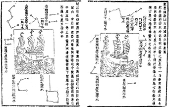
 Chinese star charts for navigation
As part of the Commemorations of the Portuguese Discoveries an International Congress on 'Bartolomeu Dias and His Era' was held in Oporto from 21st to 24th of September 1988.
The said meeting was intended to provide a more comprehensive study of King John II and his actions in the XVth century. In order to allow the five hundred international participants to be more closely involved in the works, the congress was divided into separate symposia and each one had its own subject such as navigation, maritime trade and its relations with the economy, spirituality and evangelization, as well as the society, culture and attitudes.
At the same time, a Bibliographic-Documental Exhibition on the 'Cape Route' was opened at the Infante's House (Casa do Infante). The presentation and launching of the Seminary Minutes entitled 'Nautical Sciences and Navigation Techniques in the XⅤth and XⅥth centuries' published jointly by the Macau Cultural Institute and the Macau Maritime Research Centre was a rather important event.
In his opening address, Professor Luís de Albuquerque stressed that this important event should be followed by other events which would allow people to know more about the Discoveries and the Portuguese presence all over the world.
Macau was represented at the Congress by the said two institutions and the following paper was presented.
The symbolic presence of Macau is intended to disclose the findings of a meeting on 'Nautical Sciences and Navigation Techniques in the XⅤth and XⅥth centuries' which was jointly organized by the Macau Cultural Institute and the Macau Maritime Department. In addition, it is also our purpose to release some of the proposals comprised in the said findings concerning future meetings between Portuguese and Chinese experts in the light of the cultural cooperation between Portugal and the People's Republic of China.
In November 1987, the Macau Cultural Institute and the Macau Maritime Department organized a seminar on 'Nautical Sciences and Navigation Techniques in the XⅤth and XⅥth centuries', with Portuguese and Chinese participants.
We believe this was a very important meeting because for the first time ever Portuguese and Chinese experts had the chance to meet and exchange their views on the subject. Likewise, future cooperation was discussed.
The Portuguese Discoveries have been studied and analysed from very different angles. Documentary sources which form a basis for those studies are quite easy to obtain at least for Western researchers.
However, the long Chinese voyages in the XⅤth century are not easy to study. Very few European historians have dedicated themselves to this subject either because of the language or access to the Chinese archives.
In view of the above, the speeches by the Shanghai University and Beijing University professors as well as the members of the Portuguese Marine Academy, were extremely important because language difficulties were solved and precious information of documentary sources in China was released.
Below we give a brief account of the subjects dealt with at the Seminar.
One of the topics addressed by the Chinese was the main documentary source concerning relations between China and Gaoli (name given to the Korean Peninsula in the XⅡth century). It is the 'Gaoli Map', drawn by Xu Jing who was a senior official in the Northern Song Dynasty. He gave a description of that country's customs as well as the maritime routes, nautical and geographical knowledge, astronomical navigation techniques used by the Chinese navigators. Also it was stated that the first reference ever made to the compass which was used only when it was impossible to measure the altitude of the Sun, can be found in this Map.
Chinese maritime traffic increased in the XⅡth century. Commercial voyages were made to Japan, Indonesia, Sumatra and other Asian regions. As the new destinations were far away from the shore, new navigation techniques had to be developed.
However, organized maritime expeditions took place only in the XⅤth century and these were intended to explore the regions west of China. Most of the speeches given by the Chinese were on the seven expeditions led by Admiral Zheng He. From the information collected, the chronological order of these major voyages made by the Chinese Armada is as follows: -
1405 - The first expedition took Chinese ships to Indochina, Java, Sumatra, Ceylon and Calicut.
1407 - Chinese ships reached Cochin after calling at Siam.
1409 - It seems that the third expedition used Malacca as the base for reaching the Southwest of India and again Ceylon.
The Chinese fleet was split in the following expedition: some ships headed towards the Maldive Islands, the Gulf of Bengal and Ormuz from Ceylon, while others reached the Western Indies.
1416 - Again Zheng He's armada was split with some ships sailing towards Java, Ryukyu and Borneo, and others to Aden, Mogadishu and the coast north of Mombaza.
The last two expeditions focused on previously known regions and Mecca.
The last major Chinese maritime expedition ended in 1433 due to internal political reasons. Since huge amounts of money were being spent on the expeditions without any return, the imperial power suspended the expeditions. This completed a twenty eight year cycle (1405-1433) in which China was able to show its power beyond its geographic boundaries.
It would be useful to give an account of the Portuguese maritime voyages in the same period, when the Portuguese started looking for a new world.
It can be said that in technological terms Western countries could have engaged themselves in the discovery voyages as early as the beginning of the XⅣth century, i. e. a hundred years before they actually did. In fact, the main nautical inventions were known to the Portuguese at the time and this is based on the amount of nautical equipment brought to the Iberian Peninsula by the Arabs and Genoese.
The conquest of Ceuta in 1415 was the beginning of the long process of exploration and expansion of Portuguese territory overseas.
The voyages undertaken by the Portuguese navigators when the Chinese armada was sailing the Eastern seas, i. e. from 1405 through 1433, were scarce. This could be explained by the careful preparation in terms of objectives and proper structures of those voyages even though they were fully supported by King John I.
Some of the voyages made between 1419 and 1433 are known, such as the one by Diogo de Silves to the Azores, Gonçalves Zarco, Tristão Vaz Teixeira and Bartolomeu Perestrelo to the Madeira Islands, as well as Gil Eanes' first voyage. Gil Eanes sailed past the Bojador Cape only on his second voyage in 1434.
With the conquest of that city in the North of Africa (Ceuta), the Portuguese voyages increased until 1421. This was most probably the date in which attempts were started to go past the Não Cape. However, these attempts were slowed down until 1434, notwithstanding the discoveries of Madeira and Azores in 1419 and 1427 respectively.
There is therefore a ten year gap between the beginning of the Chinese and Portuguese maritime expeditions. Between 1415 and 1433 the Chinese made the their fifth, sixth and seventh expeditions and the Portuguese made the same number of maritime expeditions. After going past the Bojador Cape, the South Atlantic was opened to the Portuguese navigators.
When Vasco da Gama reached India in 1498, Zheng He's big ships had already left the Indian Ocean and this made any contacts between the navigators of these two countries impossible.
However, the hardships that the Chinese navigators had to face when sailing on previously unknown routes were similar to those experienced by the Portuguese some years later.
Like in Portugal, those long voyages called for improvements in naval construction and nautical sciences namely in terms of cartography and astronomical navigation. The 'Zheng He Nautical Chart' played a very important role in the evolution of Chinese cartography due to the quality and detailed information produced. On the other hand, contemporary works refer to nautical instruments used by Zheng He's fleet, especially the compass and the 'board for carrying stars' which most probably formed the basis for the Indian tables used by the Portuguese in the XⅥth century.
Giving an account of the convergences and divergences between the Chinese expeditions and Portuguese voyages some years later would be very interesting. It has never been done but it is outside the scope of this work.
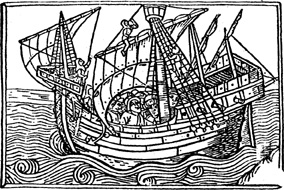
The members of the Marine Academy based their contributions on nautical matters in the Discoveries era. They presented a very detailed description of astronomical navigation by means of altitudes which was invented by the Portuguese, as well as the nautical instruments used aboard caravels and man-of-war.
Also, with a great deal of detail, the adaptations that the Portuguese had to make to the ships' sails in view of the different sailing conditions of the Atlantic Ocean, Indian Ocean and South China Sea (the latter producing the 'Lorcha') were presented. In addition, information was given about the design and preparatory stages concerning the construction of the replica of 'Bartolomeu Dias' caravel.
As regards cartography, they mentioned the 'de Cantino' planisphere as an example of Eastern influence on the Portuguese cartographers in the beginning of the XⅥth century.
The major points of this meeting were the exchange of information between those present at the seminar, the mutual knowledge of some sources of information about Portuguese and Chinese nautical matters, a first approach to mutual influences in cartography, nautical instruments and naval construction techniques. In conclusion, it was felt that more events like this should be held.

Routes taken by Zheng He's fleet on the first seven voyages
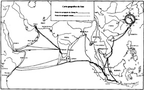
Comparison between the routes taken by Zheng He and those followed now.
In fact, one of the recommendations of this seminar was that similar events should be organized taking 'into account that Portugal is celebrating the five hundredth anniversary of the Discoveries.
Bearing in mind the great amount of temptation, planning and adventure involved, this endless and honourable page of Portuguese history is still the reason for debate over navigation techniques pioneered by the Portuguese.
The Chinese investigators declared they were interested in knowing more about Portuguese history in the XⅥth century. Likewise, Portuguese counterparts showed their intention to know more about Chinese navigation history. This will surely pave the way to a more comprehensive knowledge of Chinese history which is now just beginning to unfold.
The proposal included in the seminar conclusions for the translation of the most important documents to make room for better meetings, will certainly be taken into consideration by those institutions which normally sponsor research. These institutions will have to endeavor to collect, translate and release those documents.
We would take this opportunity to stress that there are some areas in the Discoveries which have yet to be fully investigated. According to Professor Luís de Albuquerque, one of the Portuguese participants in the seminar, many questions must be answered if a full knowledge of Portuguese Expansionist History is to be achieved.
One of those is the history of cartography since research has always focused more on the people who prepared the charts rather than the charts themselves. The logbooks written in the Discoveries era are also insufficiently explored because there is no Portuguese logbook collection concerning the XⅤth, XⅥth and XVIIth centuries.
Another important issue which is under investigated is how the new cultures met by the navigators influenced Portuguese society. An anthropological approach could be given to the existing documents on these voyages in order to find their meaning and therefore get a better understanding of the Portuguese maritime adventure.
Any study of the Portuguese Discoveries would be done on a cultural, political, scientific or technical viewpoint but this would be below the expectations. The economical side of these expeditions is very important and the study of the Portuguese Discoveries on an economic perspective is still very scarce. However, it must be said that some outstanding essays on the subject have already been produced.
The variety of subjects yet to be approached in the Portuguese Discoveries is really an attraction for researchers. Any undertaking intended to expand the understanding of both Chinese and Portuguese histories mainly in their similar and convergent interests, would be successful. This would be assured with support from Macau institutions which are interested in contributing to that success.
In view of the foregoing, the location of Macau is very important because the knowledge it has of both countries is the same and this makes it both a dissemination and agglomeration centre for those cultures.
Even though in terms of maritime contacts between Portuguese and Chinese there have been a lot of divergencies, we are sure that the Portuguese and Chinese voyages will be the basis of convergence between these two countries.
Translated from the Portuguese by José Vieira
*Historian, Macau Cultural Institute
**Historian, Macau Maritime Research Centre
start p. 107
end p.