§ 1. BACKGROUND
In the beginning the Macao peninsula comprised of four or five distinct islands:
1. The main island, which stretched from the Barra (Inner Harbour's Bar), by Nossa Senhora da Penha de França (Our Lady of Penha de França), São Lourenço (St. Lawrence's [Church]), Santo Agostinho (St. Augustin's [Church]) and the Sé (See [Cathedral]) to São Paulo (Saint Paul's [Church]) and the 'morro de Camões' (lit.: 'Camões' mound'), ended up in Patane. From the Monte (Mount [Fort]) it stretched to the old Hospital de São Rafael (Hospital of St. Raphael) and São Lázaro (St. Lazarus [Chapel]), the ancient 'monte de São Miguel' (lit.: 'St. Michael's mount'). Without going into detail, which can be dealt with in another work, one could say it was bordered by the Mage miao or Ma Kok Miu (Temple of Ama) to that of Patane in a line drawn from Praia do Manduco (Manduco Beach) to the Alfândega (Customs House) -- at the end Praça de Ponte e Horta (Ponte e Horta Square)-- with a slight bend in the direction of the Largo do Senado (Senate Square), Misericórdia (Misericordy), São Domingos (St. Dominic's [Church]), crossing the Rua de Nossa Senhora do Amparo (Street of Our Lady of Assistance), Rua Tercena (Tercena Street) and Rua dos Faitiões (Street of the Fah-tie) until the Tarrafeiro ([Street of the] Fishermen) almost alongside the actual lake of the Igreja de Santo António (St. Anthony's Church), continuing, always close to the the 'morro de Camões' (lit.: 'Camões' mound'), until the Patane 'Pagoda' [Soit Ut Kun Miu].
The northern and eastern sides were surrounded by the Rua do Patane (Patane Street), Rua Coelho do Amaral (Coelho do Amaral Street) and Rua de Adolfo Loureiro (Adolfo Loureiro Street) until reaching the Jardim do Lou Lim Iok (Lou Lim Iok Garden) area, following Avenida do Conselheiro Ferreira de Almeida (Counselor Ferreira de Almeida Avenue) and Rua do Campo (Campo Street) until Rua Formosa (Formosa Street). The southern part was bordered by Praia Grande (Praya Grande) until Bom Parto (Fortress of Our Lady of Safe Delivery), verging onto Chunambeiro (lit.: 'lime furnace'; Chunambeiro [Street]) and from there until Barra ([Fort of St. James at the] Bar), alongside Avenida da República, (Avenue of the Republic) and Rua de São Tiago (St. James Street).
Admittedly it comprised of two Islands, later joined together between Sé (See [Cathedral]) and the Monte (Mount [Fort]): Ilha da Guia (Guia Island) and the 'morro de São Jerónimo (lit.: 'St. Hieronymus' mound') and 'morro de São Francisco' (lit.: 'St. Francis' mound'), which extended from Praia de Cacilhas (Cacilhas Beach) until the rocks at the edge of Praia Grande (Praya Grande) in front of São Francisco (St. Francis' [Convent]).
It was surrounded by the sea at the land where the Zona de Aterros do Porto Exterior [ZAPE] (Area of the Outer Harbour Reclamation) is today and, on the other side, in the vicinity of Avenida de Sidónio Pais (Sidónio Pais Avenue) and Rua de Ferreira do Amaral (Ferreira do Amaral Street), Rua de Horta e Costa (Horta e Costa Street) today, and converged at the ancient Convento de Santa Clara (St. Clare's Convent) until São Francisco (St. Francis' [Convent]).
1. Ilha de Mong Há (Mong Ha Island), which began alongside the Lin Fong Miu (Temple of Lin Fong and reached the 'morro de Mong-Ha' (lit.: 'Mong Ha mound' [Fort]), at 'morro da Montanha Russa' (lit.: 'Russian Mountain's mound'), and the 'morro de Dona Maria' (lit.: 'Dona Maria II mound' [Fortress]) and stretched out until Macau-Seac with a rocky ledge which would later serve as the foundations for a wall to enclose a water reservoir beside Rua dos Pescadores (Fishermen's Street).
It was surrounded by the sea, notably around Avenida do Coronel Mesquita (Colonel Mesquita Avenue), the end of Rua do Almirante Lacerda (Admiral Sérgio Street), between the canal and the Lin Fong Miu Temple of Lin Fong), Estrada do Arco (Arch Street) and from there, always following the mountain and the Companhia de Electricidade de Macau [CEM] (Macau Electricity Company) installations and Temple of Tin Hau, continued by the rocks, which, on the other side, led to today's Praia de Cacilhas (Cacilhas Beach) and from there to Avenida do Coronel Mesquita (Colonel Mesquita Avenue).
2. Ilha Verde (Green Island).
§ 2. DEVELOPMENTS UNTIL THE SIXTEENTH CENTURY
The fact that Macao was situated in a delta with high sedimentary deposits, especially in the east, caused silting up between the Islands, which became interconnected:
The first two, between Monte (Mount) and Guia, perceptible between the end of Rua da Colina (Hill Street) and the old Hospital de São Rafael (St. Raphael's Hospital) were where the old royal canal (for sewerage) began.
-- The second and third, in the area designated for Praia de Cacilhas (Cacilhas Beach), also situated by Mong Ha, joined the mainland with a straight isthmus between Lin Fong Miu (Temple of Lin Fong) and Porta do Limite (Boundary Gate).
-- Ilha Verde (Green Island) is just over a hundred years old (1891-1991) and is connected to Mong Ha by an artificial isthmus, developed by the Counselor Miguel Borja. The continuation of the works on the ports was under the authority of the chief engineer, Adolfo Loureiro, who moved to Macao specifically to carry out this project.
The strengthening of Praia de Cacilhas (Cacilhas Beach) necessitated the separation of Porto Exterior (Outer Harbour) and Porto Interior (Inner Harbour), contributing to a rapid accumulation of sand which would end up becoming the low flatlands of Mong Ha, located in the bay between Avenida do Coronel Mesquita (Colonel Mesquita Avenue), Avenida da Flora (Flora' a Avenue) -- later known as Avenida de Sidónio Pais (Sidónio Pais Avenue)-to Rua do Campo (Campo Street) and from there, along the bottom of São Lázaro (St. Lazaru's) and Tap Seac, a sector including Rua de Adolfo Loureiro (Adolfo Loureiro Street), Rua de Coelho do Amaral (Coelho do Amaral Street) and Rua do Patane (Patane Street) until Rua do Pagode (Pagoda Street).
The Springs of Mong Ha -- together with the Kun Iam Tong (Temple of Kun Iam) and the Colina de Guia (Guia Hill -- a place with three springs, no longer there today, but close to the exit for the highway tunnel which crosses the Hill and the original area where Jardim Vasco da Gama (Vasco da Gama Garden) is -- helped with the land's desalination and its adaptation for agriculture, resulting in bringing settlers who established what would become the village of Mong Ha where they devoted themselves to planting rice, their basic food. By the river bank the flatlands were flooded depending on to the tides and floods.
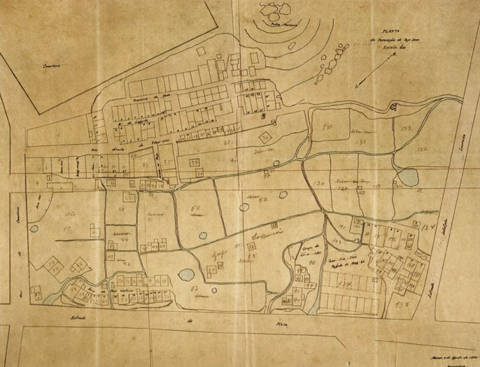 FACING PAGE:
PLAN of the village of Tap-Seac /Scale 1:400
It is particularly interesting to note:
• The housing layout of the "Tap Seac" village which follows the profile of the "Cemitério " de São Miguel ("St. Michael's" Cemetery).
• Part of the "Long-tin-chün" village, later demolished.
• The layout of the future Avenida do Conselheiro Ferreira de Almeida (Counselor Ferreira de Almeida Avenue) -- without name in the plan --,the "Estrada da Flora" ("Flora Road" -- future Avenida de Sidónio Pais [Sidónio Pais Avenue]) and the "Estrada [de] Adolpho Loureiro" ("Adolfo Loureiro Road").
• The parceled leas -- at a substantly lower level -- which occupied the present location of the sports field.
FACING PAGE:
PLAN of the village of Tap-Seac /Scale 1:400
It is particularly interesting to note:
• The housing layout of the "Tap Seac" village which follows the profile of the "Cemitério " de São Miguel ("St. Michael's" Cemetery).
• Part of the "Long-tin-chün" village, later demolished.
• The layout of the future Avenida do Conselheiro Ferreira de Almeida (Counselor Ferreira de Almeida Avenue) -- without name in the plan --,the "Estrada da Flora" ("Flora Road" -- future Avenida de Sidónio Pais [Sidónio Pais Avenue]) and the "Estrada [de] Adolpho Loureiro" ("Adolfo Loureiro Road").
• The parceled leas -- at a substantly lower level -- which occupied the present location of the sports field.
Water coming out of Mong Ha, and especially Guia, naturally channelled towards the small valleys, the main ones were not far from the actual streets of Rua de Pedro Coutinho (Pedro Coutinho Street) and Estrada de Adolfo Loureiro (Adolfo Loureiro Street) until near the place where Rua da Barca (Boat Street) began, at which point they joined to become a stream which flowed into the Porto Interior (Inner Harbour) -- the Ribeira do Patane (Patane Creek).
§ 3. MACAO AT THE TIME OF THE ARRIVAL OF THE PORTUGUESE
The Portuguese peacefully settled in Macao with the consent of the Chinese, and after several unsuccessful experiences on the Imperial coast, naturally began living in the area around Patane and its stream for the water supply. Ribeira do Patane (Patane Creek), as a place for fetching drinking water had a great advantage to the Porto Interior (Inner Harbour), because it was sheltered from the gale force winds which passed nearby, especially at the beginning of the hurricane season.
Penha mountain had some natural Springs --Lilau [or Nilau], Barra and Tanque do Mainato (Mainato's Reservoir) -- but were not significant and difficult to reach (except in Lilau).
The settlement grew quickly and became a town, thanks to trading with China and Japan. It was not necessary to begin the construction of walls or forts. There was just one wall, of which a small section still exists today, which was built by the Jesuits: from Praia Pequena (Praya Pequena) to 'morro de São Paulo' (lit.: 'St. Paul's mound'), enclosing the Igreja de Nossa Senhora do Amparo (Our Lady of Assistance Church), by the sea and above it, the Igreja de Nossa Senhora da Assumpção (Our Lady of Assumption Church), the Colégio de São Paulo (St. Paul's College), part of which was a fort, the garden and houses of the Society of Jesus.
§ 4. DEVELOPMENT SINCE 1622
Following the Dutch attack, the town was fortified and walled in at the most suitable places:
1. A section of wall between Fortaleza [de Nossa Senhora] do Bom Parto Fortress [of Our Lady] of Good Delivery) and Penha ([Fort of Our Lady of] Penha [de França]) (was built; another to prevent access to Praia de Cacilhas (Cacilhas Beach), connecting the Guia ([Fortress of Our Lady] of Guia) to Dona Maria II (Dona Maria II [Fortress]).
However the main wall connected São Francisco (St. Francis') and São Jerónimo (St. Hieronymus), where it curved and followed São João (St. John's Fort) up to the Fortaleza do Monte (Mount Fort). From there it followed the outskirts of Pátio do Espinho (Thorn Yard) with Rua de Tomás Vieira (Tomás Vieira Street) -- where a large section still exists-- until Santo António (St. Anthony's [Church]), wound around the Protestant Cemetery and, halfway up the hillside between Rua do Patane (Patane Street) and the 'morro de Camões' ('Comões mound'), it headed for the area near Patane's Pagoda, where it ended with the river. This last section along the actual Jardim de Camões (Camões Garden) was of stone and from this came the Chinese name for Rua do Patane (Patane Street) as 'Street of the Stone Wall' [Port.: 'Rua do Muro de Pedra '].
Beyond the wall were the Forte de São Tiago da Barra (Fort of St. James at the Bar), to defend access to the Porto Interior (Inner Harbour) and Fortaleza [de Nossa Senhora] da Guia (Fortress of Our Lady of Guia) to keep a lookout on all ways into Macao by the Porto Exterior (Outer Harbour), and even the Porta do Limite (Boundary Gate), which had no defences high up.
The main section of the wall had two gates from where one could go out into the open fields.
1.Portas do Campo (Campo Gates) or of São Lázaro (St. Lazarus) or of São João (St. John's) at the far end where Rua do Campo (Campo Street) branched into Avenida do Conselheiro Ferreira de Almeida (Counselor Ferreira de Almeida Avenue) and Rua de Ferreira do Amaral (Ferreira do Amaral Street), leading to Sao Lázaro (St. Lazarus') and along the bottom of Guia Hill to Mong Ha.
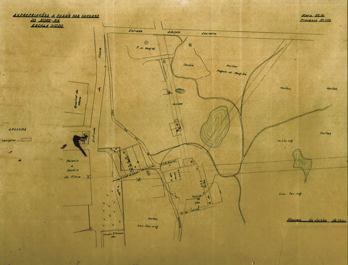 FACING PAGE:
EXPROPRIATIONS TO BE MADE IN THE LEAS OF MONG HA/SCALE 1:1000
Dated "Macau [ ] of June 1901"
It is particularly interesting to note:
•The layout of the future Avenida de Horta e Costa (Horta e Costa Avenue) -- without name in plan -- with a proposed roundabout which was never built.
FACING PAGE:
EXPROPRIATIONS TO BE MADE IN THE LEAS OF MONG HA/SCALE 1:1000
Dated "Macau [ ] of June 1901"
It is particularly interesting to note:
•The layout of the future Avenida de Horta e Costa (Horta e Costa Avenue) -- without name in plan -- with a proposed roundabout which was never built.
-- Porta de Santo António (St. Anthony's Gate) or of S. Paulo (Guangdongnese: Sam Pa Mun, or St. Paul's Gate) where today the Rua de Tomás Vieira (Tomás Vieira Street) and Rua de Coelho do Amaral (Coelho do Amaral Street) begin, and where a path which after winding around the ancient 'morro de São Miguel' (lit.: 'St. Michael's mound'), crossed the field and headed towards Lin Fong Miu (Temple of Lin Fong and Porta do Limite (Boundary Gate).
§ 5. THE EXPANSION OF MACAO
The extension of the town beyond the walls until the Porta do Limite (Boundary Gate), with Governor Ferreira do Amaral, brought the need to extend the existing roads, and to go on with opening others along with the sanitation and improvement of conditions already there.
In order to carry out these indispensable projects within and outside the wall, it was necessary to create a department specifically in charge of the work. Initially it was the Comandante do Batalhão (Battalion Commander [of the Line Formation Artillery]) who was in charge of civil and military projects. Though in September of 1867 a commission, which proposed the creation of a special body for public works, was named and in 1870, fulfilled a Decreto Régio (Royal Decree) of the 3rd of December 1869, a Serviço de Obras Públicas das Províncias Ultramarinas (Public Works Service for the Overseas Provinces) was set up ordering each province to have a director, an engineer (in the case of being military it could be from the general staff or the artillery). Therefore Tenente Coronel (Lieutenant) Domingos José de Almeida Barbosa became the director of services. On the 15th of July 1870, Francisco Jerónimo Luna was named Major do Estado Maior de Engenharia (Captain General of Engineering) and held the post until the 21st of August 1871.
The arrival of officials in Military Engineering,--whether as Governors José Rodrigues Coelho do Amaral [Joze Rodrigues Coelho do Amaral] [ 1863-1866], Firmino José [Firmino Joze da Costa] [1886-1889], ([José Maria de Sousa Horta de Costa [Joze Maria de Souza Horta e Costa] [1894-1897]), or Directors of Public Works (F. J. Luna, Horta e Costa, Constantino de Brito, Abreu Nunes and others) brought a great impetus to the projects carried out in Macao, and especially the sanitation of Chinese neighbourhoods, the flatlands, the improvement and regimentation of the streets. Special mention should be made of Governors Coelho do Amaral and Horta e Costa, Captain General of Engineering, Director of [The Provincial Department of] Public Works and Governor twice, who the Senado (Senate/Municipal Council) recognised as citizens of great merit.
§ 6. RIBEIRA DO PATANE (PATANE CREEK)
With the search for a better life, brought by trade and by immigration to America following the abolition of slavery, people arrived in Macao by boat, many of them Chinese. Several of these vessels went up Ribeira do Patane (Patane Creek) and it became their home, being a place built up with huts on top of wooden poles. In this way Sa Kong settlement was established. The river quickly silted up and hygiene conditions became such that every year the Relatório [...] (Written Report [...]) to the Director of the [Public] Health Service alerted him of the danger of an epidemic running rife.
Based on the Boletins Oficiais (Official Bulletins), below are some references -- the most important ones -- which give an overall view of the flatlands' situation and especially the area closest to the river villages of Sa Kong, San Kiu and Patane:
A Relatório [...] (Written Report [...]) of the Serviços de Saúde (Public Health Service) was presented in the "Boletim Oficial" ("Official Bulletin") 1865-1867, p.193:
"A branch of the river crosses the village of Patane, and stretching along the field, floods a huge plot of land which presented the worst sanitary conditions. Two walls hold back the water in its riverbed, canal the water from its source, forming a sort of canal which serves as a refuge for some boats and the land, conveniently filled up with rubbish, is cultivated in some areas and taken up with a few houses in others."
"Boletim Oficial" ("Official Bulletin"), 5 Dezembro [December] 1882 -- Portaria 99 (Government Regulation 99):
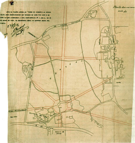 Plan of the leas/Scale 1:2000
This plan was drawn well before the date of "27/8/1926" shown in the document.
It is particularly interesting to note:
•The spatial relationship between the Povoação de "Long-tin chin" [Long-tin-chün] and "Mong Ha" [Mong-ha].
•The red layout of the proposed new streets, some of which were never built. The roundabout was also not implemented.
•The definition of the San Kiu Canal.
Plan of the leas/Scale 1:2000
This plan was drawn well before the date of "27/8/1926" shown in the document.
It is particularly interesting to note:
•The spatial relationship between the Povoação de "Long-tin chin" [Long-tin-chün] and "Mong Ha" [Mong-ha].
•The red layout of the proposed new streets, some of which were never built. The roundabout was also not implemented.
•The definition of the San Kiu Canal.
"Considering that the Canal which flows out of the river to the flatlands it obstructed by more houses above the focal area of infection, damaging public health and preventing the waters from flowing freely into the small irrigation canals, resulting in making dams in the live waters, which remain very swampy [...]" and they appointed a commission to study the situation.
"Boletim Oficial" ("Official Bulletin") no 883, 1882, p. 45:
"[The second semester of the year saw...] draining of the swamp which was beside the Estrada de Coelho do Amaral (Coelho do Amaral Road) and near San Kui canal."
"Boletim Oficial" ("Official Bulletin"), 12 Fevereiro [February] 1883, p.63:
"In San Kui Canal it is advisable that, after removing the dwellings, the river bed and its margins should be repaired and organised, so that the canal can serve the double function for which it was built, to continuously irrigate the flatlands and allow access for small vessels sheltering in the rainy season. The Sa Kong inlet needs urgent preventive measures".
"Boletim Oficial" ("Official Bulletin"), 28 Agosto [August] 1883:
The Governor Tomás de Sousa Rosa [Thomaz de Souza Roza] appointed a commission -- Director das Obras Públicas (Director of [the Provincial Department of] Public Works), Constantino de Brito; the Chefe do Serviço de Saúde (Head of the [Public] Health Service), Lúcio Augusto da Silva; Vereador (Council Member), Miguel Ayres da Silva; Administrador do Conselho (Council Administrator), Leôncio Alfredo Ferreira; and the agronomy expert, Tancredo Caldeira do Casal Ribeiro [Tancredo Caldeira do Cazal Ribeiro] to formulate a general plan for improving the city.
A Relatório [...] (Written Report [...]) by the commission was presented in the "Boletim Oficial" ("Official Bulletin"), (1) 20 Novembro [November] 1884:
It emphasised:
1. A proposal for the Avenue which connected Praia Grande (Pray a Grande) to the Porto Interior (Inner Harbour), bordering the Senado (Senate / Municipal Council) (only finally opened more than thirty years later).
2. A proposal for an Avenue to link the Fortaleza de Nossa Senhora do Bom Parto (Fortress of Our Lady of Good Delivery) by the Forte de São Tiago da Barra (Fort of St. James at the Bar), only finished in 1910 and named Avenida da República (Avenue of the Republic).
3. Sewerage.
4. Drinking water supply (three Springs in Flora (Flora's [Garden]), the Lilau little Spring and the Barra Spring).
5. The classification of unhealthy for the suburbs of Sa Kong and San Kiu:
"Patane, Sa Kong and San Kiu were real Chinese settlements and because of this one can be excused for describing the filthy state they are in."
Proposal: "Transform the irregularity of the alignment, avoid the accumulation of organic waste in the streets and lastly to establish adequate drains.
Sa Kong has, among other things, unsanitary conditions of another kind which urgently need combating. We are referring to the docks for boat building, which are full of mud and organic waste in decomposition, infecting the atmosphere. Blocking up these docks, along with granting the flood lands, which are covered with the tides, would be the way to remove that cause of unsanitary conditions.
Another improvement in the San Kiu area appears to be important. The Canal know by the same name, today overflows onto the flatlands around the dwellings built on stilts, which are reminiscent of the old lake dwellers shelters. The inhabitants' rubbish mixes with the mud, always in the open, and gives off a fetid smell which well warns of the danger of that focal area of infection".
It was considered necessary to block up the canal, leaving a covered ditch in the middle for drainage from the flatlands' waters, forming a large tree-lined avenue along the length of the actual Canal which stretched to the sea, the Estrada de Coelho do Amaral (Coelho do Amaral Road).
"Boletim Oficial" ("Official Bulletin"), Setembro [September] 1884 -- Portaria (Government Regulation):
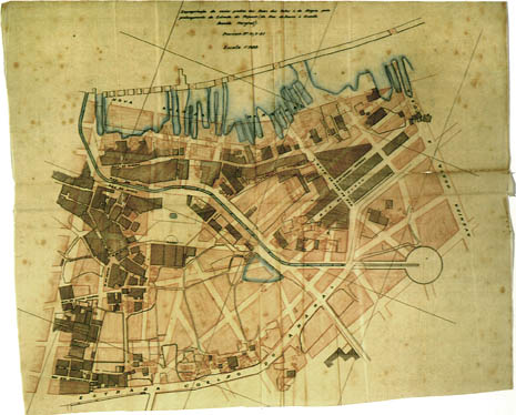
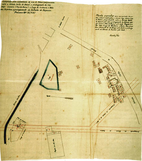 Expropriation for improvements of the Patane area between the "Estrada [de] Coelho do Amaral" ["Coelho do Amaral Road"], the continuation of the "E." [strada] [de] "Adolpho Loureiro" ["Adolfo Loureiro R. [oad]"] ("Rua da Barca" ["Boat Street"]), the "Largo da Cordoaria" ["Square of the Rope Factory"], the "Pateo das Perpetuas" ["Yard of the Everlastings"], and the continuation of the "Estrada do Repouso" ["Rest Road"]./Processo N°12/5-A1 (Procedure no 12/5-A1).
It is particularly interesting to note:
•The indication of the "Emissor San-Kiu" ("San Kiu Canal").
•The revised layout of the "Estrada do Repouso" ("Rest Road").
Expropriation for improvements of the Patane area between the "Estrada [de] Coelho do Amaral" ["Coelho do Amaral Road"], the continuation of the "E." [strada] [de] "Adolpho Loureiro" ["Adolfo Loureiro R. [oad]"] ("Rua da Barca" ["Boat Street"]), the "Largo da Cordoaria" ["Square of the Rope Factory"], the "Pateo das Perpetuas" ["Yard of the Everlastings"], and the continuation of the "Estrada do Repouso" ["Rest Road"]./Processo N°12/5-A1 (Procedure no 12/5-A1).
It is particularly interesting to note:
•The indication of the "Emissor San-Kiu" ("San Kiu Canal").
•The revised layout of the "Estrada do Repouso" ("Rest Road").
The Governor Tomás de Sousa Rosa gave the Chinese Ho-A-On, director of Tu Ti Mio 'Pagoda'; Cheong A Vá, Head of the firm Lam Mau; Vom A Hin; Fom A Su, and Ho lu Foc Tong; permission (PP81) for the building of a Dockyard in the Patane area, in front of Rua das Pontes (Bridges Street). The Dockyard was apppointed to store and preserve the timber for the construction, it being a project carried out in accordance with a general plan of works at the port and the contract from the Finance Ministry. This was to be the Doca de Lam Mau (Lam Mau Dockyard).
More, the owners were obliged to build the wall inside and out of the dock and adjoining supports within a period of fifteen months, including the wooden bridges. The filling in of earth for the roads which surrounded the dock was to be carried out at the Government's expense.
"Boletim Oficial" ("Official Bulletin"), 11 Julho [July] 1885 -- Portaria 62 (Government Regulation 62):
The Governor Tomás de Sousa Rosa stated that "[...] being extremely inappropriate for a civilised country with regard to the repugnant appearance of the Sa Kong, San Kio villages and others along the Macao coast, where one finds serving as dwellings, a large number of old boats on stilts stuck in the mud; considering these dwellings, because of the special conditions, turn the areas into real places for a focal area of infections which must be gotten rid of as they are highly damaging for public health; considering that the majority of these boats serve more readily as a shelter for vagrants and petty thieves, rather than the homes of honest working people; considering that its unusual layout and means of communication to the boats completely negates the possibility of police vigilance in the above mentioned areas, and therefore they offer a safe refuge for the criminals which seriously harms public safety".
And from that day on it was forbidden to attach boats to stilts as dwellings along the Macao coastline and an order was given allowing three months for the unconditional removal of those already there.
The Relatório [...] (Written Report [...]) of the Chefe do Serviço de Saúde (Head of the Public Health):
"The most far reaching projects for public hygiene carried out in 1885 were undoubtedly the removal of the poor boats on stilts along the Sa Kong and San Kio Canals, which served as a haven for pestilence and the filthy and miserable society which, according to public opinion, was where the great majority only led a criminal and immoral life. It was a danger to public health and safety and there were perhaps more than two thousand. A time lapse of three months was given for vacating the area. It is certain that not one of the Chinese would have decided to leave their filthy homes so it was the government's business to order them to be demolished, as previously decreed to maintain order according to the police's preventative measures".
A Relatório [...] (Written Report) of the Director of [the Provincial Department of] Public Works, José Maria de Sousa Horta e Costa was presented in the "Boletim Oficial" ("Official Bulletin"), 30 Junho [June] Setembro 1887:
"Another project of this kind -- waste pipe from the Calçado do Gaio (Gaio Pathway) to Praia Grande (Praya Grande)-- is the blocking of the San Kiu Canal leaving only a pipe for waste water from the flatlands. The task is quite costly. However, it is of such importance and would improve the city's hygiene to such an extent that I believe this project should be begun soon".
Also in a list of works:
1. Project and budget for the works needed for sanitising the San Kiu Canal;
2. Prior project for extending the Estrada de Adolfo Loureiro (Adolfo Loureiro Road) up until the Dockyards.
During the year between June 1886 and 1887:
1. The large Doca de Patane (Patane Dockyard), planned for storing wood but being used to shelter small vessels Doca de Lam Mau (Lam Mau Dockyard) was built;
2. Important embankments to block up the Doca de Patane (Patane Dockyard) which extend along the main dock where it finishes up were built;
Expropriation of several buildings from "Rua das Pontes" ["Street of the Bridges"] e da [Rua da] "Alegria" to allow the extension of the "Estrada do Repouso" ["Rest Road"] (from "Rua da Barca" ["Boat Street"] to the Grande "[Nova] Avenida Marginal" [Main "[New] Waterfront Avenue"]) /Processo -N°15/5-A1 (Procedure no 15/5-A1). ">Street of "Happiness"] to allow the extension of the "Estrada do Repouso" ["Rest Road"] (from "Rua da Barca" ["Boat Street"] to the Grande "[Nova] Avenida Marginal" [Main "[New] Waterfront Avenue"]) /Processo -N°15/5-A1 (Procedure no 15/5-A1).
This plan was drawn in 1913-1914.
It is particularly interesting to note:
•The final layout of the "Canal de San-Kin" ("San Kiu Canal") clearly shown between the rotunda (future Rotunda de Carlos da Maia (Carlos da Maia Roundabout)) and the Lam Mau Dockyard in the Porto Interior (Inner Harbour).
•The grid of the proposed new urban development which was to be slowly implemented after the demolition of the original dwellings.
3. The project of an outer wall was initiated to control the currents from the inner port, following the instructions given by the Engineer Adolfo Loureiro [Adolpho Loureiro], on top of a wooden stockade, joined by a railing covering in masonry and pebbles on top of which the wall would sit.
"Boletim Oficial" ("Official Bulletin"), 11 Julho [July] 1888 -- Portaria 100 (Government Regulation 100):
The Governor and Official Engineer Firmino José da Costa calculated that if they began the sanitation project of the San Kiu Canal and the extension of Estrada de Adolfo Loureiro (Adolfo Loureiro Road), it would take two years.
The first one hundred and fifty metres were awarded according to the notice of tender on the 17th of June 1889. The project was to begin in the first days of October 1889. In the meantime earth moving along the banks of the canal began on the 2nd of May 1889.
A Relatório [...] (Written Report [...]), referring to the time between May 1888 and 1889, from the Direcção das Obras Públicas de Macau e Timor (Administration of Public Works in Macao and Timor) was presented in the "Boletim Oficial" ("Official Bulletin"), 3 Dezembro [December] 1885, Addendum 4:
The Administration of Public Works in Macao and Timor, directed by Amâncio d'Alpoim de Cerqueira Borges Cabral, from the 24th of May 1889, and based on the information given by Alcino A. Sauvage, in charge of the project, verified that half of the funds given that year had been spent in three projects: dredging, building the retaining wall of the Porto Interior (Inner Harbour) and the building of the artificial Canal in San Kiu. The construction of the embankment around the Porto Interior (Inner Harbour) made way for more than one new road. Regarding the canalisation:
[...] fortunately the percentage of all the solid substances, aside from the designation of rubbish and fecal material produced in the city which travels through the sewage system, is very small because these residuals are, thanks to our government, sold to outside bidders who use it in farming, making profits to add to the budget's funds."
Works continued on the laying of pipes along the San Kiu Canal and the embankments around the Canal.
A Relatório [...] (Written Report [...]) of the Serviço de Saúde ([Public] Health Service) was presented in the "Boletim Oficial" ("Official Bulletin"), 24 Outubro [October] 1892:
"One of rare areas of infection today which is still present in Macao city and perhaps the most dangerous of all, is the Sa Kong neighbourhood, the main cause being the unsanitary conditions of the San Kiu Canal [...] much has been done in the past few years to improve the sanitary conditions of this settlement [...] and [...] it was not that long before the [Public] Health Service protested in vain about the sanitation of the urban suburbs of Horta da Mitra (Mitra's Vegetable-garden) and Horta do Volong (Volong's Vegetable-garden)."
"Boletim Oficial" ("Official Bulletin"), 27 Outubro [October] 1892 -- Portaria 133 (Government Regulation 133):
The Governor Custodian Miguel de Borja ordered the conclusion of the project for the sanitation of the San Kiu Canal after the report presented to him by the Health Department, as he saw the actual situation, strongly agreeing that the truly unsanitary and damaging state of the areas of San Kiu and Sa Kong which the canal referred to crossed.
The Edital (Proclamation) from the Senado (Senate/Municipality) of the 27th of February 1893:
Prohibition the dumping of rubbish along the San Kiu Canal, making it only possible to empty earth wastes and debris.
The project to regulate the borders of the San Kiu Canal began on the 2nd of March 1893 until the end of June, costing 3,921,073 Patacas.
"Boletim Oficial" ("Official Bulletin"), (18) 1 Maio [May] 1894- Portaria 109 (Government Regulation 109):
The Governor José Maria de Sousa Horta e Costa ordered the immediate start of the "[...] continuation of the sanitation project of San Kiu Canal which, due to overriding circumstances, was in a truly filthy state around the areas of San Kiu and Sa Kong, with a budget of 2,000 Patacas."
According to an Edital of the 18th of October 1894, the Chinese inhabitants were informed:
"The Governor has. decided to build new suburbs in Sa Kong set aside for family housing for the poor and with hygienic conditions, taking advantage of the uncultivated land there, though not being able to carry this out for the moment as the land is covered with Chinese graves, and for this reason we advise all those interested in these graves to exhume the corpses within the period of two months from this date; and if they do not do it, the exhuming will be carried out by the Government".
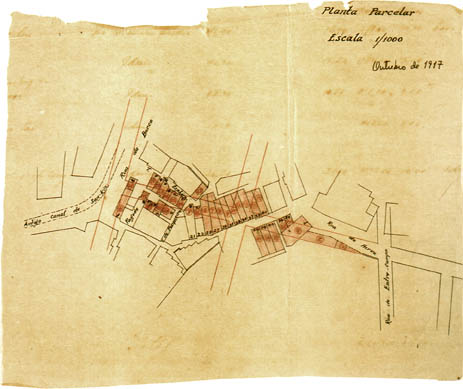
Fraction Plan / Scale 1:1000
Dated: "October 1917"
It is particularly interesting to note:
•The disappearance of the old Rua das Pontes (Street of the Bridges) and in this joint updated survey and revised urban development.
On the 12th of January 1895, land in Sa Kong was leased to a Chinese businessman, Lu Cau, with the aim of building cheap housing and starting a working class area which would progressively stretch from San Kiu to Mong Ha.
On the 9th of August 1895, instructions were given for "[..] the construction of drainage, laying pavements and tree planting in the new area of Sa Kong already built [...]" and the necessary work to be carried out for the sewerage system to empty into the inner port through the San Kiu Canal.
"Boletim Oficial" ("Official Bulletin"), 28 Novembro [November] 1896- Portaria 168 (Government Regulation 168):
Governor José Maria de Sousa Horta e Costa approved the costs and estimate for the project of levelling out the land, laying pavements and installing drains required in the Sa Kong area, and expropriating fourteen dwellings. (the expropriation for public use referred to previously in PP 13 from the 8th of February 1896).
The Edital (Proclamation) from the Senado (Senate/Municipality) of the 14 Dezembro [December] 1899:
Stated that"[...] it is acceptable to have an area designated for dumping rubbish, waste material and refuse from building work [...]," and for this use the two lakes in San Kiu, near the Travessa do Lago (Lake Alleyway), were chosen.
The Edital (Proclamation) from the Senado (Senate/Municipality) of the 27 Dezembro [December] 1899:
Stated that apart from those two previous areas, the area alongside the river and the Estrada de Coelho do Amaral (Coelho do Amaral Road) between the ruined dock bridge and Mong Ha suburb could be used for the same purpose.
"Boletim Oficial" ("Official Bulletin"), 27 Junho [June] 1913 -- Portarias 176, 177 & 178 (Government Regulations 176, 177 & 178):
The following budgets and decisions on the carrying out of projects were:
1. The construction of the San Kiu drainage Canal Estrada de Coelho do Amaral (Coelho do Amaral Road) along the length of the Estrada do Repouso (Rest Road) (232.5 metres), and
2. Draining the San Kiu Rotunda.
"Boletim Oficial" ("Official Bulletin"), 1913-- Portaria 184 (Government Regulation 184):
Expropriations made for the sanitation of the Patane area between Estrada de Coelho do Amaral (Coelho do Amaral Road), the lengthening of Estrada de Adolfo Loureiro (Adolfo Loureiro Road) [Rua da Barca (Boat Street)], and the Largo da Cordoaria (Square of the Rope Factory) and Pátio das Perpétuas (Amaranths' Yard).
"Boletim Oficial" ("Official Bulletin"), 1914 -- Portaria 87 (Government Regulation 87):
Made official the lengthening of Estrada do Repouso (Rest Road), between Rua da Barca (Boat Street) and the Avenida do Almirante Lacerda (Almirante Lacerda Avenue).
In 1913 there was also the launching of a public auction for several projects, among which were the completion of the drainage Canal in San Kiu and the reclamation of the old canal.
"Boletim Oficial" ("Official Bulletin"), 6 Junho [June] 1914 -- Portaria 109 (Government Regulation 109):
Decreed the estimate and provision for the project of paving the street above the San Kiu drainage Canal, and for the lengthening of Estrada de Adolfo Loureiro (Adolfo Loureiro Road) from Rua da Barca (Boat Street) to Avenida de Horta e Costa (Horta e Costa Avenue).
In 1921 it was decided to extend the San Kiu drainage system to the outer limits of the future Dockyards near Avenida do Almirante Lacerda (Almirante Lacerda Avenue), having the project been approved in November of 1922 and the beginning of March 1923 when a competition was set up for additional works.
§ 7. THE PRESENT SITUATION
Little remains of the area where the Ribeira do Patane (Patane Creek) had previously developed. The flatlands, lakes, river and Canal up to the Sa Kong neighbourhood have disappeared.
There is still a vestige of the canal which comes to life even today at the height of the great rains when Rua da Barca (Boat Street) turns into a real canal gathering all the rain water from Macao' s large basin. This was caused by not having made a higher embankment and by the water exit going further and further away each time.
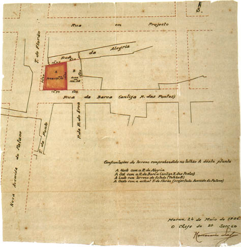
Frontages of the parcel included in lot A of this plan
North: "R. [ua] da Alegria ["Street of Happiness"]
South: "R. [ua] da Barca" ["Boat St. [reet]"] (old "R. [ua] das Pontes" [St. [reet] of the Bridges"])
East: with a parcel belonging to the Government (lot B)
West: with the present "T. [ravessa] do Florão" ["Florão A. [lleyway]"] (proposed "Avenida do Patane" ["Patane Avenue"])
Dated: "Macau, the 24th of May 1926"
It is particularly interesting to note:
• The total lack of references to the San Kiu Canal, already mentioned as the "Antigo canal de San-kin" ("Old San Kiu Canal") in the "October 1917" survey.
An abundant historical study, for some forgotten reason, but which remains connected to the old river and of which there are still examples.
Rua da Ribeira do Patane (Patane Shore Street) (1868)
Built as a marginal road.
It ended and ends precisely south of the place where the San Kiu Canal flows into the Porto Interior (Inner Harbour). A grand waterfront avenue was built later to the north, and was given the name of Avenida do Almirante Lacerda (Almirante Lacerda Avenue), which allows us to pin point it today as the place where Ribeira do Patane (Patane Creek) ends.
Estrada da Ribeira do Patane (Patane Shore Road) (1896)
Presumably the same as the previous one.
Largo da Ribeira (Creek Square) (1896)
Travessa da Ribeira (Creek Alleyway) (1868) (1878)
What exists today is just a crossing of Rua da Ribeira do Patane (Patane Shore Street) not physically connected to the old riverlet.
Rua da Barca (Boat Street) (1868) (1878) (1896)
Referring to the boats that came up the river and the vessels which anchored along the shorelines. Originally they anchored in San Kiu Canal on the southern side. When San Kiu Canal was filled in, the streets which ran alongside Rua da Barca (Boat Street) and Rua das Pontes (Street of the Bridges) were realigned, disappearing except for Rua da Barca (Boat Street) which mainly stayed above the old San Kiu canal.
Rua da Ponte (Bridge Street) or
Rua das Pontes (Street of the Bridges) (1868-1878)
It ran alongside the old San Kiu Canal to the north.
"Boletim Oficial" ("Official Bulletin"), 12 Março [March] 1874 -- Portaria 22 (Government Regulation 22):
Authorised a public auction and reconstruction of the main wooden bridge over Sa Kong Canal.
A short time later two supports were displaced as a result of the damage caused by the typhoon of the 22nd and 23rd of September 1874. There were three secondary wooden bridges which were all damaged in the typhoon.
"Boletim Oficial" ("Official Bulletin"), 18 Novembro [November] 1875 -- Portaria 114 (Government Regulation 114):
In 1875 the building of two bridges was instigated: in San Kiu and Sa Kong.
They were finished on 24th of January 1876, at the cost of 728,000 réis (Reals).
"Boletim Oficial" ("Official Bulletin"), 18 Setembro [September] 1914 -- Portaria 81 (Government Regulation 81):
Was named Rua das Pontes (Street of the Bridges)
It disappeared when the San Kiu Canal was filled in.
Travessa da Ponte (Bridge Alleyway) (1868) (1878) (1896)
This road still exists, perpendicular to Rua da Barca (Boat Street) and its ending at San Kiu.
Travessa da Ponte Nova (New Bridge Alleyway) (1896)
It was referred to in 1896 but has since disappeared, but perceptible around Rua de João Araújo (João Araújo Street).
Travessa do Lago (Alleyway of the Lake) (1898) (1878) (1896)
It still exists today and joins Rua da Barca (Boat Street) to the old lake at the end of Avenida de Horta e Costa (Horta e Costa Avenue) and ended up being filled in.
Rua dos Arrozaes (Street of the Rice Fields) (1878) (1896)
It was a crossroad in 1868 and has since disappeared.
Rua de San Ti (San Ti Street) (1878) (1896)
San Ti was a village, just at the bottom of Avenida de Horta e Costa (Horta e Costa Avenue), which developed around the river's edge up until the building of the periphery Avenida do Almirante Lacerda (Admiral Lacerda Avenue). No sign of its name remains (behind the Lido).
Povoação de Sakong (Sa Kong Village) (1896)
Located along the actual Rua da Barca (Boat Street), from the roundabout Praça Carlos da Maia (Carlos da Maia Square), ending in San Kiu. Its name has disappeared.
Bairro Novo de Sa Kong (Sa Kong New Quarters)
Originally the river had a bridge, just in the middle, but with the development of the new settlement it became necessary to build a new bridge in the place where the river had the most pronounced curve. From this the bridge got its new name (San Kiu) which ended up being used as the name for the area between Sa Kong and the Patane, at the end of Rua da Barca (Boat Street), which still remains.
Travessa de Coelho do Amaral (Coelho do Amaral Alleyway)
Rua de Coelho do Amaral (Coelho do Amaral Street)
Estrada de Coelho do Amaral (Coelho do Amaral Road)
In the beginning it was between the Porta de Santo António (St. Anthony's Gate) and Areia Preta (Black Sands' [Quarter]), and until the Estrada do Repouso (Rest Road) there were houses and it was still a road. From the Estrada do Repouso (Rest Road) to the north there were flatlands and it be-came a highway. When Governor Horta e Costa inaugurated the Avenue which had his name, the Estrada de Coelho do Amaral (Coelho do Amaral Road) was realigned, passing perpendicularly and ending at Avenida do Coronel Mesquita (Lieutenant Mesquita Avenue).
Estrada de Adolfo Loureiro (Adolfo Loureiro Road)
Built in 1882-1883 (754.373) and 1883-1884 (2.640.850)
The lengthening of the future Rua da Barca (Boat Street) (PP 100 of 1888)
The name is attributed to the official who was in Macao at the time in 1883 as the Capitão de Engenharia (Captain of Engineering) and Major do Estado Maior (Major General). He formulated a grand earth moving project around the Porto Interior (Inner Port). Later the project changed on several occasions.
Avenida de Horta e Costa (Horta e Costa Avenue)
José Maria de Sousa Horta e Costa, Captain of Engineering, Director of Public Works from November 1885 to 1888, Governor of Macao from March 1894 to 1896 and once again Governor of Macao between August 1900 and December 1902, was one of the main people responsible for the sanitation and rebuilding and reconstruction of the poor, filthy areas which proliferated in Macao [Volong, São Paulo (St. Paul' s), Mitra (Mitre) -- and there is a street bearing his name, and São Lázaro (St. Lazaro's), Sa Kong, Long Tin Chun, etc.], having began the opening of the avenue which carries his name today.
When he was made a distinguished citizen of Macao, at a session of the Town Council and Senate on 8th of June 1896, they hung up his portrait in the Senado (Senate/Municipal Council), which has now unfortunately disappeared, and it refers to this fact.
Travessa de Lam Mau (Lam Mau Alleyway)
It was near the place where the old Dockyard was built and was later filled in.
Translated from the Portuguese by: Linda Pearce
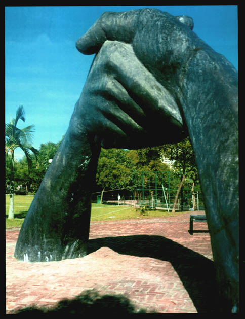
PREVIOUS PAGE:
The statue of "Friendship" in the Parque Dr. Sun Yat Sen (Dr. Sun Zhongshan Park), Macao.
Photograph taken in 1998 by Amilcar Carvalho.
* Lieutenant Engineer. From 1963 to 1970 studied at the Academia Militar (Military Academy), Lisbon. Posted in Mozambique and Guinea Bissau. Presently, Counselor to the Under-Secretary for Transportation and Public Works of the Macao government. Co-author of Um Museu em Espaço Histórico -- A Fortaleza de São Paulo do Monte (A Museum in an Historic Location -- St. Paul's Mount Fort), 1988. Author of Unidades Militares de Macau (Military Corps of Macao).
start p. 199
end p.