 The prosperity of Macao and its dominion by the Portuguese did not please the Chinese who, in 1573, constructed the gates called Border Gate (Guang.: Kuan-Chap), a veritable frontier at which the mandarins collected taxes on goods transiting between Macao and Hongshan.
At first, the gate operated only once a week but later opened every morning and closed every night. Macao was supplied by a fair which was initially held every five days. Later it was held every fifteen days and the trading areas corresponded to the accesses of Border Gate, that is the Istmo de Ferreira do Amaral (Ferreira do Amaral Isthmus) and Rua do Hipódromo (Hippodrome Street) [W. B. - 37. Racing Ground. ]. After the construction of Border Gate Portuguese sovereignty was limited and defined. The [local] mandarin imposed certain rules controlling the population, trade, construction and buildings, and the number of ships anchored in the port, and levied custom duties.
It was however, the Portuguese community which orientated trade. It was a trade they had learned to control - profitable but improvised. And, contrary to Goa, Cochin, Colombo and Malacca that were enriched by the Portuguese, Macao was a Portuguese creation which flourished from nothing, becoming a rich emporium between Malacca and Japan.
In addition to being an important centre of merchants and navigators its most important role was played by the missionaries. The Catholic Church gave Macao an appearance which is today still reflected in the organisation of the area. Various religious Orders were established which left the mark on the settlement with the construction of their churches and convents. It was around these that the population congregated, the Jesuits attracting the greater number of people. The Portuguese lived in luxurious houses and were related to best families of India. They accumulated large fortunes thanks to the commerce with Japan and Manila, benefiting from the fact that the Spanish had ceased direct trade.
The prosperity attracted the interest of other nations who attacked the city in 1604, 1607, 1622 and 1627. Successive attacks made the organisation of an efficient defence system imperative.
The Chinese authorities who had always resisted the installation of large scale fortifications finally ceded and in 1622 made the Portuguese responsible for the defence of the area.
To improve the rudimentary sixteenth century equipment, the old forts were renovated at the beginning of the seventeenth century, after the first Dutch attack.
In spite of prosperous trade the city developed uncertainty as it swelled or emptied according to the obstacles imposed by the Portuguese or by the mandarins. Considered a fortress in 1619, it had a population two years later of about seven-hundred to eight hundred Portuguese and half-castes and ten-thousand Chinese. The latter were established on the outskirts, expanding the already existing villages and forming new Chinese settlements.
Outside the walls there were seven Chinese villages on the extremities of the peninsula (Barra and Macao Seac), and five located between the walls and Mong-há (Patane, Sam Kiu, Mong-há, São Lázaro (St. Lazarus) [W. B. - 13 Village of S. Lazarus.] and Lon-Tin-Ching. They maintained the traditional structure, the regularity of lines of modest rectangular houses, a roof and two slopes, a uniformity broken only by the adaptation of the physical characteristics of the site and the relation of the houses to the surrounding scenery (water/ fishermen, cultivated land/farmers) or an important building.
The prosperity of Macao and its dominion by the Portuguese did not please the Chinese who, in 1573, constructed the gates called Border Gate (Guang.: Kuan-Chap), a veritable frontier at which the mandarins collected taxes on goods transiting between Macao and Hongshan.
At first, the gate operated only once a week but later opened every morning and closed every night. Macao was supplied by a fair which was initially held every five days. Later it was held every fifteen days and the trading areas corresponded to the accesses of Border Gate, that is the Istmo de Ferreira do Amaral (Ferreira do Amaral Isthmus) and Rua do Hipódromo (Hippodrome Street) [W. B. - 37. Racing Ground. ]. After the construction of Border Gate Portuguese sovereignty was limited and defined. The [local] mandarin imposed certain rules controlling the population, trade, construction and buildings, and the number of ships anchored in the port, and levied custom duties.
It was however, the Portuguese community which orientated trade. It was a trade they had learned to control - profitable but improvised. And, contrary to Goa, Cochin, Colombo and Malacca that were enriched by the Portuguese, Macao was a Portuguese creation which flourished from nothing, becoming a rich emporium between Malacca and Japan.
In addition to being an important centre of merchants and navigators its most important role was played by the missionaries. The Catholic Church gave Macao an appearance which is today still reflected in the organisation of the area. Various religious Orders were established which left the mark on the settlement with the construction of their churches and convents. It was around these that the population congregated, the Jesuits attracting the greater number of people. The Portuguese lived in luxurious houses and were related to best families of India. They accumulated large fortunes thanks to the commerce with Japan and Manila, benefiting from the fact that the Spanish had ceased direct trade.
The prosperity attracted the interest of other nations who attacked the city in 1604, 1607, 1622 and 1627. Successive attacks made the organisation of an efficient defence system imperative.
The Chinese authorities who had always resisted the installation of large scale fortifications finally ceded and in 1622 made the Portuguese responsible for the defence of the area.
To improve the rudimentary sixteenth century equipment, the old forts were renovated at the beginning of the seventeenth century, after the first Dutch attack.
In spite of prosperous trade the city developed uncertainty as it swelled or emptied according to the obstacles imposed by the Portuguese or by the mandarins. Considered a fortress in 1619, it had a population two years later of about seven-hundred to eight hundred Portuguese and half-castes and ten-thousand Chinese. The latter were established on the outskirts, expanding the already existing villages and forming new Chinese settlements.
Outside the walls there were seven Chinese villages on the extremities of the peninsula (Barra and Macao Seac), and five located between the walls and Mong-há (Patane, Sam Kiu, Mong-há, São Lázaro (St. Lazarus) [W. B. - 13 Village of S. Lazarus.] and Lon-Tin-Ching. They maintained the traditional structure, the regularity of lines of modest rectangular houses, a roof and two slopes, a uniformity broken only by the adaptation of the physical characteristics of the site and the relation of the houses to the surrounding scenery (water/ fishermen, cultivated land/farmers) or an important building.
 which in Chinese means ) chunambo (oyster lime). The bronze foundry directed by Manuel Tavares Bocarro was also situated there, and the quality of the production made Macao a centre of exports to Siam and China.
chunambo (oyster lime). The bronze foundry directed by Manuel Tavares Bocarro was also situated there, and the quality of the production made Macao a centre of exports to Siam and China.
Within the walls of clay mortar or chunambo the seventeenth century Portuguese city expanded, the buildings agglomerating in the main centres already existing in the sixteenth century: the zones of the Harbour, Santo António (St. Anthony)-Patane, Monte (Mount Fort)-Sé(See) [W. B. - 14 N. E. wall. ] and a more open and extensive axis along Central Street towards Penha Hill. Portuguese illustrations of the period, certainly the most exact, are few and sometimes incorrect and destitute of any reference scale. The drawing of the city reproduce in Volume II of Ásia Portuguesa (Portuguese Asia) by Faria e Sousa is very simplified and particularly emphasises the wall and defence posts. The plan of Macao drawn by Pedro Barreto de Resende to illustrate the manuscript by António Bocarro [°1594] entitled Livro das Plantas de Todas as Fortalezas, Cidades e Povoações do Estado da Índia Oriental (Book of the Plans of All the Fortresses, Cities and Towns of the State of East India) is more correct. It locates the principal religious buildings and marks the surrounding areas and zones if greater occupation, thus giving a picture of the whole complex and the areas forming part of it. In this work the city is described as a small settlement of traders, with a limited number of buildings in stone, brick and wood, situated to the Northwest of the peninsula near St. Paul's Church. There was another area with houses and commerce near St. Lawrence's Church which extended almost up to Praia do Manduco (Manduco Beach) [W. B. - 40 Praya Manduco. ]. The Chinese residential areas were near the temples and Praya Grande) had a large number of wooden houses. The area to the Northwest, adjacent to the Inner Port was probably the oldest area of occupation and was served by the Rua de Santo António (St. Anthony's Street), Rua de São Domingo (St. Dominic's Street) and Rua do Hospital (Hospital Street), built in the econd half of the sixteenth century. The occupation of the space to the Northwest probably dates from after 1590 and eveloped along Central Street, Rua de São Lourenço (St. Lawrence's Street) and Rua do Padre António (Father Anthony's Street). The zone of Barra also expanded in this period thanks to the settlement of a prosperous Chinese community which erected its buildings there. The streets were winding and the organisation of the plots indicated lack of previous planning. The city did not yet have a consolidated structure and the most important buildings were the churches and the Chinese warehouses. António Bocarro also refers to difficulties to obtain food supplies when the Chinese limited imports. According to the chronicler, the population consisted of eight hundred and fifty Portuguese and five thousand one hundred slaves, in addition to pilots and navigators. There were also Chinese Catholics whose numbers are not mentioned.
 The popular Mercado Vermelho (Red Market)
at the junction of the Avenida de Horta e Costa (Horta e Costa Avenue) and the Avenida do Almirante Lacerda (Admiral Lacerda Avenue).
Institute Cultural de Macau (Cultural Institute of Macau) Photographic Collection, Macao.
The popular Mercado Vermelho (Red Market)
at the junction of the Avenida de Horta e Costa (Horta e Costa Avenue) and the Avenida do Almirante Lacerda (Admiral Lacerda Avenue).
Institute Cultural de Macau (Cultural Institute of Macau) Photographic Collection, Macao.
Illustrations in the works of foreign travelers such as the Atlas of Johannes Vingboons and the Diary of Peter Mundy, and Dutch and English engravings included in the route-rooks and collections of the period, are most very generalised and are often simply fanciful references where we can identify some constructions and the approximate form of the city. These constitute illustrations rather than accurate iconographic sources.
However, the description of Peter Mundy (1637) confirms that the city was organised around the churches. The houses with gardens, courtyards and terraces were similar to those of Goa and the two-sided sloping roofs were reinforced against typhoons. Peter Mundy refers to the development of Praya Grande, the fortifications and the occupation of Ilha Verde (Green Island). In 1638 Macao possessed six convents - Jesuit, Capucin, Dominican, Augustinian, Franciscan and Clare. There were two parishes, São Lourenço (St. Lawrence) and Santo António (St. Anthony), and the Ermida de São Lázaro (St. Lazarus Chapel) built outside the [city] walls for the lepers. In addition to the industries located in Chunambeiro there were also small silk factories annexed to the Chinese warehouses to the Northwest and Southwest of the settlement. Between St. Paul's Church and the sea, a rich population of Western merchants lived in fine houses.
The expulsion of the Portuguese from Japan in 1639 and the consequent loss of trade was a financial disaster for Macao which was partly compensated by the opening of other markets in Timor, Solor, Macassar (Makasar) and China.
In the middle of the eighteenth century the city was organised round Central Street, Rua Direita (Straight Lane), and the Largo do Leal Senado (Senate Square) into which two main streets and seven secondary streets emerged. Construction was unrestricted especially in the Portuguese zone where no regulations applied. The predominant characteristics of the urban structure were the open spaces round the churches and public buildings. The streets were irregular and the domestic architecture was limited to a style similar to that of Goa, with details altered by the Chinese artisans. The Portuguese population expanded towards the settlement of Barra. The houses occupied valleys and hills and generally had two floors connected by a wooden staircase. The predominant colour was white, enhanced by frameworks around doors and windows in yellow, pink and blue. The Chinese community occupied the Western sector and gradually expanded along the Porto Interior (Inner Harbour). They resided in areas of high density occupation in compact constructions forming combinations of shop/residence along very narrow streets. The houses were all made of brick, roofed with tiles, and their verandahs formed a complex of great diversity. Up to the nineteenth century this area was known as the Grande Bazar (Grand Bazaar) [W. B. - 15 Bazaar.].
At that period another community still existed in Macao - Persians, who were located in Barra.
When in 1685 the 'doors' of China were opened to foreign trade the mandarins thought of transforming Macao into a Chinese port. There followed a period of great uncertainty which terminated with the opening of a Chinese Customs post in 1688. Known as Hopu [Port. transliteration; Hebo], the oldest located at Praya Pequena, near Tercena Street and the most recent, the least important, at Praya Grande on the spot were the Treasury building stands today. These tributes were levied on ships ailing for Guangzhou and this had a negative impact on the economic life of Macao. To aggravate the financial situation the ground-rent was also increased and a residence tax imposed.
 A Portuguese padrão facing the new headquarters' building of the Luso International Bank,
at Avenida do Doutor Mário Soares (Dr. Mário Soares Avenue).
Photograph taken in 1999 by Joaquim Castro.
A Portuguese padrão facing the new headquarters' building of the Luso International Bank,
at Avenida do Doutor Mário Soares (Dr. Mário Soares Avenue).
Photograph taken in 1999 by Joaquim Castro.
Originated and developed by the pragmatism of commercial momentum, to which it was always elated, the origin of the trading post and, later, the city of Macao cannot be traced to any erudite or traditional model of European or even Chinese roots. With the immediate implantation of the religious structures it was the buildings - churches and convents - which congregated and unified the population. Simultaneously, these small architectural complexes and the surrounding areas of a civic and religious character (the squares and churchyards) were reference points in the structure and image of the city. The erection of the walls contributed to the regulation and clarification of the structure, introducing a sense of unification in an irregular and apparently disorganised area.
§4. THE ARCHITECTURE -EUROPEAN AND CHINESE MODELS
Archeological remains of this period of the city's history are scant except for the iconographic documents already mentioned. Engravings in the works of Portuguese authors show the general physiognomy of the complex and the internal organisation of the settlement, but do give a correct idea of the details of the buildings.
The first graphical registers of the city contained in atlases and route-books of voyages of the seventeenth century, are generally fanciful and show little detail.
The first Portuguese constructions were rudimentary and precarious, similar to those generally constructed in the trading posts of Asia. The churches were of wood with a single nave, a simple chapel and a plain façade. They were gradually replaced by lath-and-plaster constructions at the beginning of the eighteenth century and only later became larger, ornamented stone buildings, embodying simplistically the spatial tradition and characteristics of the mannerists façades of Portuguese architecture.
If the recent arrivals brought with them architectural models and building methods from their country of origin, they found a large part of their work force and construction materials in the territory. It is not difficult to imagine that the first houses of the Jesuits and the merchants were Chinese constructions or that typically Chinese building methods were used in the first wooden churches. The commercial area, directly connected with maritime activities and a meeting point of the two communities, was probably, in architectural terms, predominantly Chinese. Outside the city, the temples and houses of the Chinese villages perpetuated the traditional architectural models of the region, characterised by a great simplicity of form and space.
 The Hotel Riviera (Riviera Hotel), built in 1828, demolished in 1971.
Its dancing teas and 'American' dinners were important meeting points of the 'fashionable' local society.
Instituto Cultural de Macau (Cultural Institute of Macau) Photographic Collection, Macao.
The Hotel Riviera (Riviera Hotel), built in 1828, demolished in 1971.
Its dancing teas and 'American' dinners were important meeting points of the 'fashionable' local society.
Instituto Cultural de Macau (Cultural Institute of Macau) Photographic Collection, Macao.
In the sixteenth century European architecture began to spread concurrently with the development of Chinese traditions of space and construction. From these mutual influences resulted the original proposals which reflect the synthesis of local culture. Within the context of European architecture the religious buildings were influenced by two sources, Portugal and Spain. Four of the five convents built in that period were founded by religious Orders of the Spanish province- São Francisco (St. Francis) [W. B. -3 S. Francis.], São Domingos (St. Dominic) [W. B. -26 Church of S. Domingos.], Santa Clara (St. Clare)[W. B. - Church of Sta. Clara.] and Nossa Senhora da Graça (Our Lady of Mercy). The spatial model of the churches is the mannerist plan of the Jesuit type.
The church of the Convento de Sao Paulo (St. Paul's Convent), founded by the Jesuits at the end of the sixteenth century has affinities with other buildings of the same Order, such as the Igreja de São Paulo (St. Paul's Church) in Dio, The [Portuguese] State of India, and the Igreja de Jesus (Church of Lord Jesus) in Luanda, Angola. The primitive wooden construction was replaced by a larger, more carefully projected building which was inaugurated at Christmas in the year 1603 but was only completed in 1640. Of this vast monumental complex, most of which was destroyed by fire in 1835, there remains the long interior flooring and the imposing façade which rises above the steps. This façade of the Jesuitic type has no towers and is composed of three sections separated by three columns, the higher section having four floors and the lateral sections two floors. Local artisans worked on it. Portuguese, Chinese and also Japanese Catholics recently settled in the city, who all left signs of their work. The decoration includes Baroque elements of the Western type and images of Oriental origin - an exotic and original complex and a confluence of erudite international themes with Portuguese, Chinese and Japanese interpretations. The convent was a vast building of two floors disposed irregularly around a large courtyard.
The old wooden church of the Convento de São Domingos (St. Dominic's Convent), founded in the sixteenth century by Dominicans from Acapulco, was replaced by the present church in the eighteenth century. The principal façade is a typical composition of the period, the central section having three floors topped by a triangular pediment connected to the lateral, lower sections by means of a simplified wing. The Igreja de Nossa Senhora da Graça (Church of Our Lady of Mercy) of the Augustinian convent has a simpler, more classical façade.
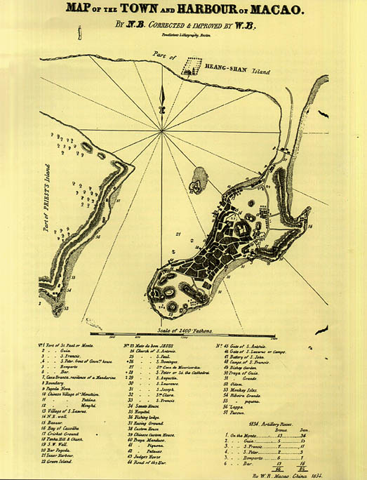
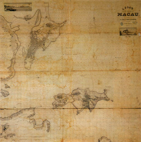
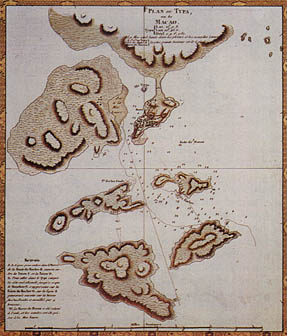 PLAN OF TYPA/OR/MACAO /Lat. 22°. 9" N. / Lon. 113.43" E./ Surveyed [...] 1780.
The plan clearly indicates Lappa Island (or of the Priests) - immediately to left of Macao -, abandoned by the Portuguese in 1780, and the Islands of Taipa and Coloane - facing Macao, at the bottom right -, occupied by the Portuguese during the time of Governor Ferreira do Amaral (1846-1849). Reprinted by the Direcção dos Serviços de Turismo (Department of Tourism- Government of Macau), 1986.
PLAN OF TYPA/OR/MACAO /Lat. 22°. 9" N. / Lon. 113.43" E./ Surveyed [...] 1780.
The plan clearly indicates Lappa Island (or of the Priests) - immediately to left of Macao -, abandoned by the Portuguese in 1780, and the Islands of Taipa and Coloane - facing Macao, at the bottom right -, occupied by the Portuguese during the time of Governor Ferreira do Amaral (1846-1849). Reprinted by the Direcção dos Serviços de Turismo (Department of Tourism- Government of Macau), 1986.
The sixteenth and seventeenth century parish churches, in spite of successive alterations and restoration works, still retain the spatial and formal characteristics of the period. Less elaborate than the convent churches, they have a single nave with side chapels and simple façades with towers _ one tower in the case of the Igreja de Santo António (St. Anthony's Church) and two in the case of St. Lawrence's Church and the Sé (See), the later being the largest of the three buildings. There were also small chapels adjacent to the military installations or at specific points of the city such as Nossa Senhora da Penha de França (Our Lady of Penha de França) [W. B. - 18 Penha Hill Church.], a simple building with a two-sided sloping roof (Our Lady of Guia), located within the fort of the same name, with a classical façade and solid buttresses, and the Igreja de São Lázaro (St. Lazarus' Church) which was later replaced by the present church.
The civil architecture also reproduced Western models but they were culturally less erudite and closer to Portuguese tradition, particularly experiences of The State of India and Malacca [Melaka]. Of the public buildings the Misericórdia (Misericordy) [W. B. -27 Church of Sta. Caza de Mizericordia.] the Senate and the centres of assistance represented by the hospital and the leprosarium were the most important. They were designed around a cloister-courtyard and had one, two or three floors in thick walls of brick and stone and two-sided sloping roofs. The main façade was characterised by large apertures. The houses were reminiscent of seventeenth century Lisbon palaces, large and heavy with a main floor over the storerooms and servants' quarters, balcony windows and simple iron grilles and a pediment above the central body. Access to the interior was through a courtyard from which the great staircase rose to the main floor. This plan remained in the traditions of Macao and can still be seen in houses of the period such as those at the corner of Rua de São José (St. Joseph's Street) and Rua da Prata (Silver Street). The interior decoration was inspired by Oriental taste and habits.
A complex of fortresses, small forts, bastions and a wall based on a modern fortified system was built in the seventeenth century, delimiting and defending the city. Although they had always prevented the construction of a solid defensive system, the Chinese authorities charged the Portuguese with the defense of the city and the territory which was constantly attacked by the Dutch.
From 1616 new constructions were planned to protect the coastline and, in 1622, the government levied a special tax on the ships of the 'Japan voyage' - the caldeirão (lit.: cauldron) - to subsidise the construction of the equipment required to transform the city into a modern citadel. The wall then erected was solidly constructed of clay mortar and included fortresses, forts and small forts. Starting from the Porto Interior (Innner Port) it linked up with the Fortaleza da Palanchica (Palanchica Fortress) and Fortaleza do Monte (Mount Fort), following to the Fortaleza de São Jerónimo (St. Hieronymus' Fortress), also called Fortaleza de São Januário (St. January's Fortress) and to the coast in the precints of the Convento de São Francisco (St. Francis' Convent) where the fort of the same name rose at the entrance of Praya Grande. Protecting the bay, it continued along the coast to the Fortim de São Pedro (St. Peter's Bulwark) [W. B. - 4 Fort of S. Peter. front of Govnrs. house.] and the Fortaleza de Nossa Senhora do Bom Parto (Fortress of Our Lady of Good Delivery; opularly known as Bomparto Fort) [W. ∫. - 5. Fort of Bomparto], rising thereafter to the zone of Penha where another fort, was erected. The wall then descended to the harbour, the whole extension of which was also protected by a curtain wall in which dock gates were opened.
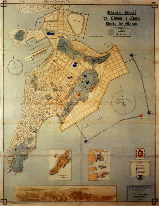 General Plan of the City and the New Harbour of Macao 1927
JOÃO CARLOS ALVES - JOÃO BARBOSA PIRES
The expansion of the city and its new reclamation areas were decided by of the Comissão dos Portos de Macau (Commission of the Macau Harbours) created in 1918 with the specific purpose to implement the urban development of the city in associatioon with new harbour zones.
General Plan of the City and the New Harbour of Macao 1927
JOÃO CARLOS ALVES - JOÃO BARBOSA PIRES
The expansion of the city and its new reclamation areas were decided by of the Comissão dos Portos de Macau (Commission of the Macau Harbours) created in 1918 with the specific purpose to implement the urban development of the city in associatioon with new harbour zones.
Transit between the Portuguese city and the Chinese villages was through the traditional Porta de Santo António (St. Anthony's Gate) e da Porta do Campo (Campo Gate) [W. B. - 46 Gate of S. Lazarus or Campo.] in the section of the wall between the Fortaleza do Monte (Mount Fort) and the Fortaleza de São Januário (St. January's Fortress), and also through small gates and doors along the coast. Outside the walls of Guia Fort, built on the highest point in the territory and the Fortaleza de Santiago da Barra (Fortress of St. James of Barra; popularly known as Barra Fort) [W. B. - 6 Fort of Bar.], built on the extremity of the peninsula near the Chinese temple [of Ama], acted as advanced defence posts which controlled access to the port.
Some zones of the East coast of the peninsula, habitually frequented by the Chinese communities but easily accessible from the sea, such as Cacilhas Beach, were also protected by a wall. The regional defence was completed with a complex of batteries and a fort on Lappa Island.
Almost all these constructions were adjusted to modern defensive tactics and adapted the fortified system to the topography and extension of the different localities. The Fortaleza do Monte (Mount Fort), a simple, regular, polygonal construction is closer to erudite models without, however, having recourse to elaborate solutions such as the construction of trenches, simple esplanades or revelins. In some of them such as Guia Fort and the Fort of Our Lady of Penha de França, in addition to the small chapels or hermitages for use of the garrisons stationed in the soldiers' quarters, a cistern was generally constructed in the parade ground. During the seventeenth century, the majority of the curtain walls bordering Chinese territory were destroyed but some forts survived.
At the same time, traditional Chinese architecture persisted and developed, mainly in the form of new houses for the numerous Chinese population, which had increased considerably in the city, a new temple of Kun Yam Tong, [W. B. -9 Pagoda Nova.] near the old Kung Yam Ku Miu in the village of Mong-há and the renovation of Ma-Kok-Miu in Barra [W. B. -20 Bar Pagoda.]. The new Kung Yam Tong, which was to become one of the most important Chinese temples in Macao, is typical of the region of Guangdong, constructed in large rectangular units with a two-side sloping roof.
CHAPTER III
MACAO BETWEEN EAST AND WEST
§1. THE EIGHTEENTH CENTURY
POLITICAL AND ECONOMIC
CONJUNCTURE AND THE
NEW RELATIONSHIP BETWEEN
EUROPE AND CHINA
THROUGH MACAO
The most significant events of the eighteenth century were the opening of the port of Guangzhou and the establishment of foreign trading Companies in Macao. With the publication of the [Chinese] Imperial Decree that in 1685 determined the opening of that port to foreigners, once a year during the fair, Macao ceased to be the only emporium for China's export trade and the Portuguese the sole intermediaries. This circumstance completely altered the economic development in the region. In a first phase the consequences were negative for the city's economy and only in 1718, when the Chinese were forbidden to trade (with the exception of the Macanese. Only when the number of Portuguese and Chinese ships registered in the city rose from four to twenty-three, did the opening of the fair and port of Guangzhou become important [to the economic prosperity of Macao]. The foreign trading Companies built warehouses on Shamian Island where their officials remained during the period of the fair as they were not permitted to enter Guangzhou itself. They negociated directly with the Mandarin Company, created in 1720, which held the monopoly of the local trade. The various European Companies and the one American, therefore established their headquarters in Macao which became an obligatory intermediate stage for access to Guangzhou.
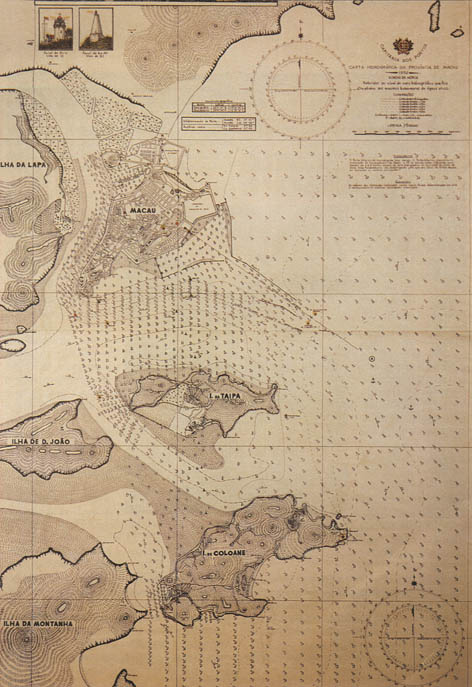 HARBOUR AUTHORITIES/HYDROGRAPHIC CHART OF THE PROVINCE OF MACAO / 1954
Note the recent reclamation area sharply destroying the western end of the previously preserved shoreline of the Baía da Praia Grande (Praya Grande Bay).
HARBOUR AUTHORITIES/HYDROGRAPHIC CHART OF THE PROVINCE OF MACAO / 1954
Note the recent reclamation area sharply destroying the western end of the previously preserved shoreline of the Baía da Praia Grande (Praya Grande Bay).
The Chinese mandarins forbade the passage of large ships, installed a Customs House in the city -The Grande Hopu (Great Hebo) of Praya Pequena - and created the post of Customs Mandarin of Macao who resided in the territory. In this manner they efficiently controlled access to estuary of the Pearl River and collected customs duties.
The economy and urban life changed with the presence of foreigners. A large part of the city's revenues was derived from taxes on and residence permits for foreigners. As a consequence of the new economic structure the city's revenues fell as the official structures were replaced by private Companies. At times of crisis the Senate was obliged to raise loans from the Church, Chinese traders and even the King of Siam.
Macao's resources in the eighteenth century also originated from customs and port anchorage duties. Commerce was in the hands of private Portuguese, Chinese and European entities. The traditional Chinese products, to which tea was added, transited through Macao. Here they were transferred from the small ships arriving from Guangzhou to large ocean-going vessels. The Portuguese merchants introduced snuff into China which was most appreciated. At the same time the clandestine commerce in opium and laudanum began to increase. This was carried out in French and British ships on the high seas but also brought financial benefits to the intermediaries of Macao.
The division of powers between the various Portuguese organisations was altered. The civil power became increasingly independent of the religious structures which were going through a period of crisis. With the expulsion of the Augustinian Friars from the city in 1712 as a result of the controversial Question of the Rites (which debated the concept of the Divine God and Emperor, as well as hierarchies of power), and of the Jesuits, in 1759, the field of action of the religious Orders was restricted. Their possessions were transferred to the Episcopal administration whose diocese was then restricted to the Chinese provinces of Guangdong and Guangxi.
The Governor took control of the Mount Fort where he traditionally resided but which was considered the property of the Jesuits. After 1767, measures were taken to acquire a suitable palace in the area of Praya Grande which was finally purchased in 1771, when government headquarters were definitely transferred to that area.
 The building of the Quartel dos Bombeiros de Macau (Macao Fire Brigade),
at the junction of Estrada do Repouso (Rest Road) with Photograph taken around 1930.
João Loureiro Collection, Macao.
The building of the Quartel dos Bombeiros de Macau (Macao Fire Brigade),
at the junction of Estrada do Repouso (Rest Road) with Photograph taken around 1930.
João Loureiro Collection, Macao.
The powers of the Senate were clarified and defined by a Royal Warrant of 1712 which referred to the spheres of political government, which included all cases related to the well being of the city and the preservation of peace and tranquillity, and economic government which consisted in the collection of taxes and tributes and the spending of the revenues resulting therefrom. The procurator conferred with the mandarin and although a Royal Order issued from Lisbon in 1712 forbade obedience to local Chinese authorities, in practise proceedings were concerted by the intervention of the Senate.
The number of Chinese Catholic converts hand increased considerably and the Church appointed a representative called 'the Father of the Christians' to superintend problems arising between this group, the Portuguese and other Chinese. Controversy generally involved situations of dependence and servitude. The Senate finally intervened in 1703, forbidding Europeans to buy Chinese slaves for export, and in 1774, forbidding Chinese Catholics to use Western dress.
 CHINA/EASTERN COAST/MACAO/WITH ITS ADJACENTS ISLANDS AND SHORES/Made by/ Mr. C. E., W. A. READ/1865-6-- detail.
In: CALADO, Maria-MENDES, Maria Clara-TOUSSAINT, Michel, Macau, Memorial City of the Estuary of the River of Pearls, Macao, 1985, p.84.
CHINA/EASTERN COAST/MACAO/WITH ITS ADJACENTS ISLANDS AND SHORES/Made by/ Mr. C. E., W. A. READ/1865-6-- detail.
In: CALADO, Maria-MENDES, Maria Clara-TOUSSAINT, Michel, Macau, Memorial City of the Estuary of the River of Pearls, Macao, 1985, p.84.
In this context the physiognomy of Macao changed from the economic, urban, populational and ethnic points of view, in a complex structure of co-existence powers. The Chinese gradually gained the ascendancy, to such an extent the Chinese Penal Code of 1779 contained rules for the administration of Macao and the Senate began to have Chinese chapas (Laws) translated and published and used specialised interpreters. The abandonment by the population of Lappa Island after 1722, [W. B. - 54 Ribeira Grande.; 55 Ribeira pequena.; 57 Pacsun] where the Portuguese legal structure was established by the religious Orders, brought the territory into the area of the city of Macao and Ilha Verde (Green Island), the remaining islands being used merely for anchorage and supply purposes.
At the end of the eighteenth century government structures were changed resulting in a division between the Senate and the government, while simultaneously the authority of the Church was re-established. The application of a new fiscal policy with the creation of a Portuguese Custom-House was also an important event. The progressive decline in revenue from the trading activities of the Portuguese in Macao resulted in the presentation of various reports and petitions by the local authorities to the governments of The State of India and Lisbon. The archaic empirical structures of the territory proved increasingly inoperable and ill-adapted to the international political and economic circumstances of the period: the doctrines of liberalism proclaimed free enterprise and competition to which the monopolistic traditions of a decadent Portuguese commerce could not respond.
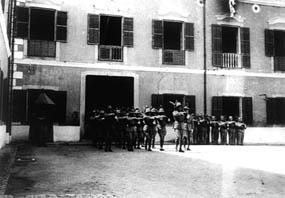 Military parade on the yard facing the Quartel de São Francisco (St. Francis' Barracks).
The former Convent of St. Francis housed the first contingent of the Overseas Regiment in the early 1930s.
Photograph taken in the 1930s.
João Loureiro Collection, Macao.
Military parade on the yard facing the Quartel de São Francisco (St. Francis' Barracks).
The former Convent of St. Francis housed the first contingent of the Overseas Regiment in the early 1930s.
Photograph taken in the 1930s.
João Loureiro Collection, Macao.
Macao was not affected by the Pombaline reforms and specific measures on the local government and economy were only published in the reign of Queen Dona Maria I [°1734-r.1777-†1816]. These measures, decreed in 1783 and implemented in the territory the following year, were denominated Providências Régias (Royal Enactments). This document issued by the Lisbon government was based on an analysis of the structures of Macao, particularly as regards the economy, the government and the interrelation of organs of power. The solution indicated to solve the crisis were: - reorganisation of the government system with revised coordination and division of powers; reorganisation of commerce based on the fiscal system; the installation of a regiment of local militia; the re-establishment of the seminary and the reorganisation of the missions in Macao and China, with the participation of priests, missionaries and particularly Jesuits, with a view to developing diplomatic activities in the Court of Beijing. These changes tended to affirm Portuguese sovereignty in the area. The post of Governor began to be exercised by the same person for a minimum period of three consecutive years, renewable when considered advantageous and useful. Qualities of forcefulness were indicated as fundamental and it was recommended that preference be given to the appointment of military candidates. Although the Senate had local powers and representation in relations with the Chinese authorities its activities were regulated by means of obligatory consultations with the government. To reinforce the authority of the representative of the central power, a military force was formed of one-hundred sepoy and fifty gunners, recruited in Goa every six years. The Seminário de São José (St. Joseph's Seminary) [W. B. - 31 Church of S. Joseph] was established and handed over to the Lazarists in 1784, and the activities of the Church regained their former influence with the consequent reinforcement of religious authority. But the former prestige of the religious Orders was not restored and power was principally concentrated in the Bishop and the diocese. The Church purchased land and properties in the territory to increase its revenues and arrange space for the installation of missions, and in 1828 the St. Joseph's Seminary acquired Green Island. As a result of the restructuring of the religious authority the principal churches, of lath-and-plaster construction, were rebuilt in durable materials: St. Lawrence, in 1801; St. Augustine, in 1814 and St. Clare, in 1824.
The government, supreme representative of the Portuguese authority, was now supported by a military force that was more efficient in defence against pirates and reprisals by French and British ships than in actions against the Chinese. The administration of the territory also became more efficient and the governmental structure had greater stability which enabled it to initiate programmes of development and improvements in the city with some prospects of continuity, including the construction of roads and connecting thoroughfares between the Portuguese city and the Chinese settlements. In this context the construction of the Mong-há road and the earthworks and cuttings in the Penha Hill, with layout of roads, were particularly important.
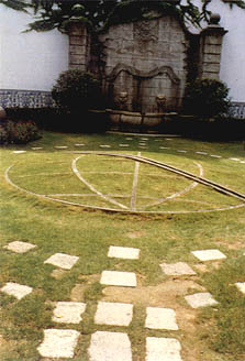 An armilary sphere - one of the symbols of the Portuguese maritime discoveries - rendered in stone in the lawn of the inner garden of the Leal Senado (Macao Municipality).
The Senate powers and authority were apparently diminished, theoretically withdrawn by the government. In practice it continued to be the most representative organ as regards the Chinese regional authorities while the government dealt with the supreme representative of Empire diplomacy. In 1788 the Portuguese authorities recognised that the Senate represented the government in relations with the mandarins and practice became rule with legal support. The actuation of the Senate in local politics was so efficient and valuable that in 1818 the members of that body were given the right to be addressed as 'Senhoria' ('Lordship'). The statute was maintained during the first years of the Portuguese constitutional regime and lasted until 1834 when the functions of the Senate were limited to those of a Municipal Council.
The Portuguese Customs [W. B. - 38 Custom House.], created in 1784, had its own building near the harbour between Praya Pequena and Manduco Beach, in a extension of the Portuguese city. It had a body of officials who applied the respective statute, collecting anchorage dues from ships which entered the harbour and levying customs duties on imported merchandise.
The immediate effect of this fiscal policy was an increase in revenues. Ultimately the Customs authorities were subject to the Governor who controlled and administered the revenues, part of which reverted to the central government. Some of the money was spent on renovations to the city, particularly the harbour zone which was provided with a new quay and warehouses.
An important part of the revenue produced by customs duties was destined for the central government. and was paid annually accompanied by a financial report. Within the context of the new colonial policy which began to take shape at the beginning of the nineteenth century, the territories or colonies had to become profitable and contribute to the general expenses of the kingdom. For this reason measures for the reorganisation of official trade in Macao had positive results, principally within the general context of the Portuguese economy.
In addition to local control, which covered the harbour movements, the Customs also superintended the direct trade between Macao and Brazil. This trading line was only authorised in 1810, after the general opening of the Brazilian ports, and benefited from certain privileges and tax exemptions. The Oriental products carried to Rio de Janeiro were intended for the Portuguese Court which had recently left Lisbon and settled in that colony wowing to the instability resulting from the French invasions in Europe and particularly the Iberian peninsula.
An armilary sphere - one of the symbols of the Portuguese maritime discoveries - rendered in stone in the lawn of the inner garden of the Leal Senado (Macao Municipality).
The Senate powers and authority were apparently diminished, theoretically withdrawn by the government. In practice it continued to be the most representative organ as regards the Chinese regional authorities while the government dealt with the supreme representative of Empire diplomacy. In 1788 the Portuguese authorities recognised that the Senate represented the government in relations with the mandarins and practice became rule with legal support. The actuation of the Senate in local politics was so efficient and valuable that in 1818 the members of that body were given the right to be addressed as 'Senhoria' ('Lordship'). The statute was maintained during the first years of the Portuguese constitutional regime and lasted until 1834 when the functions of the Senate were limited to those of a Municipal Council.
The Portuguese Customs [W. B. - 38 Custom House.], created in 1784, had its own building near the harbour between Praya Pequena and Manduco Beach, in a extension of the Portuguese city. It had a body of officials who applied the respective statute, collecting anchorage dues from ships which entered the harbour and levying customs duties on imported merchandise.
The immediate effect of this fiscal policy was an increase in revenues. Ultimately the Customs authorities were subject to the Governor who controlled and administered the revenues, part of which reverted to the central government. Some of the money was spent on renovations to the city, particularly the harbour zone which was provided with a new quay and warehouses.
An important part of the revenue produced by customs duties was destined for the central government. and was paid annually accompanied by a financial report. Within the context of the new colonial policy which began to take shape at the beginning of the nineteenth century, the territories or colonies had to become profitable and contribute to the general expenses of the kingdom. For this reason measures for the reorganisation of official trade in Macao had positive results, principally within the general context of the Portuguese economy.
In addition to local control, which covered the harbour movements, the Customs also superintended the direct trade between Macao and Brazil. This trading line was only authorised in 1810, after the general opening of the Brazilian ports, and benefited from certain privileges and tax exemptions. The Oriental products carried to Rio de Janeiro were intended for the Portuguese Court which had recently left Lisbon and settled in that colony wowing to the instability resulting from the French invasions in Europe and particularly the Iberian peninsula.
 in the <i>Praia Grande </i>(Praya Grande). </b>
</JZ>
<figcaption>This front wing was added to the old building in 1872-74 and demolished in 1946.
The <i>Novo Palácio das Repartições </i>(New Government Palace) as it still stands was inaugurated on the 30th of June 1954. </figcaption></figure>
<p>
In addition to official Portuguese, foreign and Chinese trade, the latter under mandarin control, there was, on a reduced scale, the Macao trade practiced by the inhabitants of the territory. Although the Royal Enactments had centralised the most profitable trade, leaving less scope for private initiative, the creation of the <I>Casa de Seguros </i>(lit.: Insurance House) or <i>Casa Forte </i>(lit.: Strong House) in 1817 improved prospects, permitting small traders and companies to enroll and cover their risks. These merchants traded principally with the Chinese in the villages of the region but also frequented the ports of Manila, Timor and Siam. The paid taxes for use of the harbour and on the products in circulation but a large part of their trading activities and movements remained beyond the reach of the fiscal authorities. The largescale opium trade in the hands of the French and British was frequently supported by local merchants who facilitated transactions. Expressly forbidden by the Chinese authorities, in 1828, it continued clandestinely in a circuit dominated by the foreign Companies who brought the product from India and the coasts of Asia and introduced it into China through the merchants of Macao. The transactions were effected on distant stretches of the coast outside the control of the Portuguese and Chinese authorities. Initiated about the year 1720 it was at first tolerated by the mandarins in exchange for the payment of fifty Patacas a box, but it was officially forbidden by the Imperial Laws. By the second half of the eighteenth century it had become common, gradually intensifying thereafter until in the first quarter of the nineteenth century it produced the greater part of trade revenues, which were beyond official control and did not revert directly to the entities and organisations responsible for the administration of the city. The other products in circulation were traditional ones: tea, pearls, silk, porcelain, rice and sandalwood, the monopoly of the latter having terminated in 1785.
</p>
<p>
It is thus evident that it became an increasingly regular and accepted situation for economic structures to co-exist with the exercise of illegal trade carried on by small local merchants, whose profits were calculated to be considerable but were impossible for the fiscal authorities to control and account for. As result there was a certain prosperity among the small number of Macao families and a progressive accumulation of wealth, mentioned by sources of the period but only expressed publicly in the new constructions of the second half of the nineteenth century.
</p>
<figure><img src=) The Peninsula of Macao.
The so-called 'MASTER OF THE FIRE' (Chinese School).
Ca1815. Oil on board. 11.0 x 15.0 cm
The Peninsula of Macao.
The so-called 'MASTER OF THE FIRE' (Chinese School).
Ca1815. Oil on board. 11.0 x 15.0 cm
§ 2. THE DYNAMICS AND STRUCTURE OF
THE URBAN SPACE DURING THE
EIGHTEENTH CENTURY
In the eighteenth century Macao maintained a spatial structure identical to that of the former period. The Portuguese area developed between the St. Anthony's Church, Patane, Mount Fort, the St. Paul's Church and the sea. The wealthier section of the population was concentrated here, essentially comprised of merchants and some officials of the government which was still installed in St. Paul's).
Portuguese and other foreigners also settled in the St. Augustin's Convent, the Convento de São José (St. Joseph's Convent) and the Convento de São Lourenço (St. Lawrence's Convent). The Central Street was long and linked the See to the chapel Our Lady of Penha de França. It was later extended to Barra but in first half of the eighteenth century occupation extended to St. Lawrence's. Here there were the characteristics of an urban periphery with large gardens and small kitchen-gardens attached to the houses. Between St. Lawrence's and the coast there was a commercial area, the Bazarinho (Little Bazaar) which supplied the residential area mentioned above. This area circulated via the Rua da Casa Forte (Strong House's Street) and Rua da Praia do Manduco (Manduco Beach Street) which was very frequented and formed part of the area of prostitution, an activity still recalled by the name of the Travessa da Maria Lucinda (Maria Lucinda's Alley), proprietress of one of the most famous 'houses' of the period. At the end of the century, around 1797, Manduco Beach began to be used as a wharf.
 The old Hospital de São Januário (St. January's Hospital).
Built in 1920 by the Baron of Cercal and the Captain Dias Coelho in a hybrid neogothic-cum-neoclassical style. It was one of the best example of the grand eclectic architecture which blossomed in Macao during the last two decades of the nineteenth century.
Photograph taken in the 1920's.
João Loureiro Collection, Macao.
The old Hospital de São Januário (St. January's Hospital).
Built in 1920 by the Baron of Cercal and the Captain Dias Coelho in a hybrid neogothic-cum-neoclassical style. It was one of the best example of the grand eclectic architecture which blossomed in Macao during the last two decades of the nineteenth century.
Photograph taken in the 1920's.
João Loureiro Collection, Macao.
As in the previous century the Portuguese city continued to be organized around the churches and convents surrounded by ample, open, public spaces, in contrast to the Chinese zone situated to the North between St. Augustine, St. Paul's and the sea. Here elongated blocks, crossed by narrow streets and alleys were filled with two-storey houses, the lower floors occupied by the family business and small artisan industries. The alleys generally served for the circulation of the pedestrians but some were cul-de-sacs and acquired a certain degree of privacy. North of this complex was the Praya Pequena Street where the most important Chinese Custom House was situated. Here too were concentrated the Chinese who worked on the 'teang fai', small, swift ships that crossed the China seas. The whole of this area constituted the Grand Bazaar, the fulcrum of which St. Dominic's, the Street of the Merchants, the Eastern ends of Street of the Herbalists and Rua das Estalagens (Street of the Inns), and the Rua da Palha (Straw Street), the name of which derived from the concentration there of establishments selling that product. Further to the North there was another urban area between the St. Anthony's Church and the sea, which extended to the Rua do Tarrafeiro (Street of the Fishermen) and Rua do Botelho (Botelho Street). Near the later proliferated the tancas [Guang.] (house-boats) the population which caught shrimps with tarrafas [Port.] (nets), an implement which originated the present name of the street. Chinese artisans resided in the area between the house-boats and the church and their activities are recalled in the names of the Rua dos Adufos (Street of the Adobes) and Rua dos Carpinteiros (Street of the Carpenters). Southwest of St. Anthony's the Western structure was maintained. There were large squares with religious buildings - St. Paul's, St. Francis, St. Clare and the See - with ample space around them. The streets were irregular but there were two main thoroughfares: one passing the Senate which linked Central Street to St. Paul's Street, the other which linked this fortress with St. Francis. The Dutch East India Company in the present Largo da Companhia (Square of the Company) in the Northern area of St. Paul's. Known by the Chinese as the 'Dutch Garden' it was an area related to the countryside. References to Portuguese houses with kitchen-gardens, dating from 1764, confirm the peripheral function of this complex.
Within the Western-type structure mention should be made of the consolidation of the urban complex of Praya Grande, between the forts of St. Peter's and Bom Parto. It had a wide avenue parallel to the sea, perpendicularly cut by side streets connecting with Central Street. The wall was partially destroyed, there remaining only the Eastern stretch between St. Francis and St. Paul's.
 The Praya Grande.
Unknown Chinese artist.
Ca1835. Guache on paper. 0.54 x 1.20 m.
The Praya Grande.
Unknown Chinese artist.
Ca1835. Guache on paper. 0.54 x 1.20 m.
The growth of the population of European origin was not sufficient to require expansion of the city beyond the limits already defined in the seventeenth century. On the other hand, the Chinese population increased by four-thousand, mostly in the villages of the Inner Harbour. St. Lazarus continued to be the centre for settlement of Chinese Catholics. Long-T'in-Ching and Mong-há remained agricultural villages, between them stretching an extensive cultivated plain which was the principal agricultural centre for the supply of Macao. The population of the village of Barra on the Inner Harbour, a fishing village built around the Temple of Ama, was increased by the settlement of a community of Persian traders from Guangzhou. To the North of the Largo de Santo António (St. Anthony's Square) were the riverside settlements of Patane, Sa Kong and San Kiu which were linked to maritime activities. Important for their shipyards and timber deposits they had a numerous population living in wooden huts and houses, with thatched roofs, supported on stakes, reminiscent of lake dwellings. They were built in rows but formed a disorganised complex. These villages were very unhealthy areas with malarial infections, conditions which existed along the Sankiu Channel which crossed Patane to the Sá-Kong plains.
§ 3. NEW COMPONENTS OF THE ARCHITECTURE
During the eighteenth century new architectural models of European origin were introduced, principally in civil architecture. The most significant aspect was the construction of buildings along the Bay of Pray a Grande forming a wide street or coastal promenade. These were Company installations, houses of the aristocracy and the Palácio do Governo (Government Palace). The façades opened on to the exterior by a sequence of balconies on the first floor, the buildings having a certain degree of monumentality and some decorative details. In addition to Portuguese traditions there were British influences displayed in signs of late classicism.
As a result of the increase in the Chinese population at this time, many new traditional-type houses were constructed in the area of the Inner Harbour, especially in Little Bazaar and in the areas adjacent to the upper city occupied by the Portuguese.
Some eighteenth century religious constructions and Baroque tendencies such as the Church of St. Joseph's Seminary, constructed at the top of a wide stairway. The undulated facade with two towers and a pediment, also undulated, is horizontal and irregular, revealing the centralised plan of Baroque style. A monumental cupola covers the transept. In this period a new chapel was built and dedicated to Bom Jesus (Holy Jesus) [W. B. - 23 Mato de bom JESUS] on a site near that of Our Lady of Penha de França. New temples were built in the Chinese area such as those of Ling Fong, Lin K'ai, Soi Ut Kum and Kuan Tai Ku.
During the first half of the nineteenth century the structure of the city gradually altered, the architecture being characterised by a curious synthesis of traditions and innovations. New areas were created by earth-fills in the areas of Praya Pequena and Manduco Beach, establishing a continuity of the coastline and permitting new construction. About ten blocks were constructed in regular lines between Avenida 5 de Outubro (Fifth of October Avenue) and Rua do Guimarães (Guimarães Street). These buildings, which still exist today, were the first to be designed on regular geometric lines.
Another important aspect of the organisation of the city was the installation of the cemeteries -the Catholic in 1837 in the ruins of St. Paul's, the Protestant, in 1821, and that of the Parsees in 1829. At the same time, outside the traditional limits of the city, in Penha, Barra and Guia, chácaras [Port.] (vast properties with a Summer residence) began to appear.
A part of these new tendencies was the creation of the Jardim Botânico (Botanical Gardens), presently the Luís de Camões Garden which was the forerunner of a widespread implantation of gardens and green areas in the city during the second half of the nineteenth century.
The ultimate phase of the period of foreign Companies in Macao corresponded to the spread of Neoclassical models, an erudite tendency which left its mark on the architecture. José Tomás de Aquino was one of the most prominent architects. He designed various houses, theatres and churches, reconstructed Joseph Jardim's residence in Rua do Bom Parto (Bom Parto Street) in 1834 and built a new Ermida de Nossa Senhora da Penha de França (Hermitage of Our Lady of Penha de França) in 1837, the Teatro Luso-Britânico (Luso-British Theatre) in 1839, his own house on the Santa Sancha estate (now the Governor's residence) in 1846, and the Palacete da Flora (lit.: Flora Stately House) in 1848.
§ 4. ASPECTS OF LOCAL HISTORY AND URBAN LIFE
References to daily life in Macao at the end of the eighteenth century and first half of the nineteenth century are abundant and diverse and appear in official government and Senate documents, in descriptions by foreigners visiting the city or living there and in scientific and learned works. The most important of these works are: Voyage de l'Aambassade des Indes Orientales Hollandaises vers l'Empereur de la Chine dans les années 1794 et 1795 (The Travels of the Dutch East India to the Emperor of China in the Years 1794 and 1795), Philadelphia, 1798, Voyage en Chine ou Journal de la Dernière Ambassade Anglaise à la Cour de Pékin (Travels in China or The Journal of the Latest English Ambassy to the Court of Beijing), Paris, 1819, and principally, The Diary of Harriet Low, written in the 1820's and 1830's and published in 1900 by Catherine under the title My Mother's Journal. The visual documentation of this period, represented by watercolours, engravings, drawings and paintings is also numerous and registers important details of scenes from daily life and certain environments of the city. The watercolours by Robert Elliot and Marciano Baptista, the drawings and lithographs by Auguste Borget, George Chinnery, W. Heine, I. Clarck and various works included in museum collections portray aspects of urban life and landscape with accuracy and expression. Topographical surveys resulted in the plans of 1808, 1820 and 1838 which form an accurate basis for an understanding of the urban expansion and reorganisation of the traditional areas.
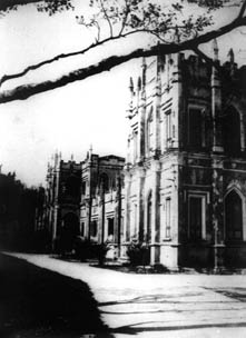
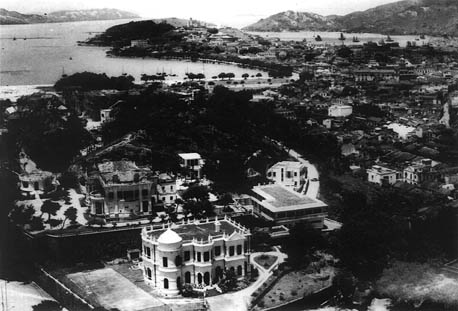 South-southeastern panoramic of the peninsula of Macao taken from the heights of Colina da Guia (Guia Hill).
In the foreground is the so-called 'Casa Branca' ('White House')- presently the Convent of the Precious Blood [of Jesus Christ] - a private house drawn in 1916-1917 by the British architect John Lemn. Behind it and slightly to the left, is another private residence, the so-called 'Vila Alegre' ('Jolly Villa') - presently, the Ling Nam School - drawn in 1917-1918 by the Portuguese architect José Tomás Silva. These town mansions were among the best examples of many built in the Portuguese colony during the first decades of the twentieth century.
Photograph taken in the late 1940s.
RC Photographic Collection.
South-southeastern panoramic of the peninsula of Macao taken from the heights of Colina da Guia (Guia Hill).
In the foreground is the so-called 'Casa Branca' ('White House')- presently the Convent of the Precious Blood [of Jesus Christ] - a private house drawn in 1916-1917 by the British architect John Lemn. Behind it and slightly to the left, is another private residence, the so-called 'Vila Alegre' ('Jolly Villa') - presently, the Ling Nam School - drawn in 1917-1918 by the Portuguese architect José Tomás Silva. These town mansions were among the best examples of many built in the Portuguese colony during the first decades of the twentieth century.
Photograph taken in the late 1940s.
RC Photographic Collection.
In his description of Macao, José Guimarães de Freitas refers to the aspect of the city: "[...] the streets are narrow but paved and the drains under them rapidly draw off the rain water. The city is walled to the North and the South. Here there are two gates which communicate with the countryside. Between the gates to the North raises the Fortaleza de São Paulo do Monte (popularly known as Mount Fort) [W. B. - 1 Fort of St. Paul or Monte.]; to the South there are two forts one of which is the Forte de Nossa Senhora da Penha de França [Fort of Our Lady of Penha de França]; three fortresses defend the bay at the entrance to which is Barra Fort; on a hilltop is Guia Fort. A long quay called Praya Grande has a charming wall; the Western part overlooks the harbour and an island formerly donated to the Jesuits [...]" (FREITAS, José de Aquino Guimarães, Memoria sobre Macau, Coimbra, Imprensa da Universidade, 1828, pp.11-13 [sic]).
The Catholic population was distributed between the See, St. Lawrence's and St. Anthony's which had two-thousand one-hundred and thirty, one-thousand seven-hundred and twenty, and four-hundred and fifty six inhabitants, respectively. The Chinese totaled eight-thousand but outside the walls there were twenty two-thousand pagan Chinese.
The Portuguese city was also inhabited by foreigners who introduced new habits. The Portuguese - military, merchants and administrative personnel - were Catholics and the churches continued to be centres of collective life. The foreigners - merchants and their families - were mostly Protestants and constructed their own places of worship and cemeteries.
The Macanese which lived in the Portuguese city had assimilated many Western habits, especially as regards behaviour, dress and style of life. In the opinion of foreigners this city was elegant with big houses and gardens.
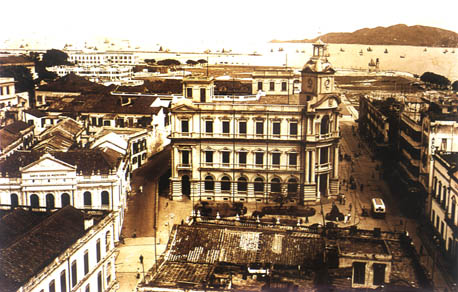 Bird's eye view of the Largo do Leal Senado (Leal Senado Square).
In the foreground, the rooftops of the Edifício Ritz (Ritz Building); in the middle ground the imposing headquarters of the Correios, Telégrafos e Telefones [CTT] (Post Office, Wireless and Telephones), built in 1931; to the left, the new revivalist façade of the Misericórdia (Misericordy); and in the right the Avenida Almeida Ribeira (Almeida Ribeiro Avenue) continuing towards the new reclamation areas at the western end of the Praya Grande Bay.
RC Photographic Collection.
Bird's eye view of the Largo do Leal Senado (Leal Senado Square).
In the foreground, the rooftops of the Edifício Ritz (Ritz Building); in the middle ground the imposing headquarters of the Correios, Telégrafos e Telefones [CTT] (Post Office, Wireless and Telephones), built in 1931; to the left, the new revivalist façade of the Misericórdia (Misericordy); and in the right the Avenida Almeida Ribeira (Almeida Ribeiro Avenue) continuing towards the new reclamation areas at the western end of the Praya Grande Bay.
RC Photographic Collection.
Some idea of the living conditions of the inhabitants can be obtained from the transcription of an extract from a letter written in the 15th of May 1829 by the procurador (Attorney) of the city of Macao to the mandarin of the Casa Branca (White House) [W. B. -7 Caza Branca, residence of a Mandarine. ] who asked about life and trade in Macao: "The city has less population and less houses. The Emperor having permitted the Portuguese to live there, between the Border Gate and Barra, they only occupy a small area, leaving the beaches free for unloading and concentration of their ships and using some fallow ground for their market-gardens. But during the last twenty years the Chinese population, which was eight hundred souls, has grown to forty-thousand; market-gardens and fields rented from the Chinese were cultivated. The Chinese took the fallow ground for their shops and rented many Portuguese houses which they kept without paying the rent (for example those of St. Augustine, St. Paul's Street, Gregório Abreu and Praya Pequena). These the Chinese took, building many huts even in places that were streets. Thus they continue to Barra and Patane where formerly there were houses of the Portuguese who are now restricted to Praya Grande and the houses in the centre of the city, rebuilding them when they are old; they do not take lands or their churches. The Bazaar which was formerly outside the city is now within it, as also a multitude of Chinese houses, it being impossible to distinguish those of good and those of bad men [...]."
In monsoon seasons the city suffered catastrophes which destroyed the quay and main buildings. In 1824 a fire destroyed a large part of the Convento de Santa Clara (Convent of St. Clare) and, in 1825, another ruined that of St. Paul's and its church. This nucleus, belonging to the Jesuits, had already been partly dismantled in 1788 when the library and workshops were demolished. In 1835 another fire swept through the church which was reduced to the façade and walls. It was later demolished as being irrecoverable, except for the principal façade of the church and the stairway. The interior of the church was used as a Catholic cemetery from 1838 until the construction of the new Cemitério de São Miguel (St. Michael's Cemitery). In 1831 a typhoon hit the area causing damage in the zone of Praya Grande. The promenade was widened, the protective walls strengthened and some buildings were reconstructed in the Neoclassical style.
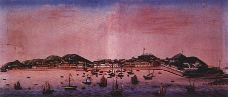
View of the Praya Grande taken from the Penha Hill.
WILLIAM HEINE.
1853. Coloured litograph.
In: HUNTER, W. C., An American in Canton (1825-44), Hong Kong, Derwent Communications Ltd., 1994, chap. III, [p. n. n.].
The Chinese urban area expanded and included new blocks of buildings erected in the area between the present Street of the Merchants and Rua Camilo Pessanha (Camilo Pessanha Street) and the Travessa da Cordoaria (Alley of the Rope Factory), Travessa do Pagode (Pagoda Alley) and Travessa do Armazém Velho (Alley of the Old Warehouse). To the West of this complex was bordered by the present Fifth of October Avenue, to the South by the present Avenida Almeida Ribeiro (Almeida Ribeiro Avenue) and to the North-Northeast by Praya Pequena Street, now known as Tercena Street. The house of the mandarin and the Hebo (Chinese Customs) of Praya Pequena were situated here. In front of this complex was the fish market.
The long blocks of buildings crossed by alleys in the area between the Street of the Inns, Camilo Pessanha Street, Street of the Merchants and Almeida Ribeiro Avenue, were occupied by Chinese houses, bordered to the Southeast by the Grand Bazaar (an area presently occupied by the Mercado de São Domingos (St. Dominic's Market) and by carpenters shops mainly connected with maritime activities. These activities also resulted in the establishment of a considerable number of ship owners in the Manduco Beach, near which the Portuguese Custom House was installed in 1783, in the street of the same name.
The Chinese villages continued to maintain an independent life and the surrounding fields supplied the Portuguese city. Green vegetables and fruit were abundant but meat, a basic element in European diet, was scarce. The temples were the principal buildings in these settlements. The Chinese cemeteries were built in the fields or on slopes and were a symbolic, religious space of great importance to this community. In addition to the tombs of wealthy families that were buildings with several rooms, these places were occupied by innumerable simple graves that were equally sacred and vital to the population and these areas were considered of public utility.
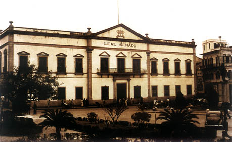
Front elevation of the Leal Senado (Senate Municipal Council).
The building façade- which has been kept to the present - is the result of a restauration proposed by Engineer Valente Carvalho and executed in 1939. This design incorporates little adjustments to the alterations made in 1876 to the previous façade of 1872 - when the building was considerably rebuilt after the devastating effects of that year's typhoon.
RC Photographic Collection.
In the first quarter of the nineteenth century a significant event was the appearance of a local periodical. This was the newspaper "A Abelha da China" ("The China Bee") which first appeared in the 12th of September 1822 under the orientation of a Dominican Friar. In 1824 it became the "Gazeta de Macau" ("The Macao Gazeteer") and in 1834 the "Crónica de Macau" ("The Macao Chronicle"), gradually becoming more regional in character, in the 9th of July 1836 the "Macaísta Imperial" ("Imperial Macanese") appeared and was published for two years. In 1838 publication was initiated of the "Boletim Oficial do Governo de Macau" ("Official Bulletin of the Government of Macao") which carried official information and government programmes.
With its own peculiar way of life, exotic and attractive to most Europeans, the city of Macao lived out the last phase of the colonial period of the sixteenth century origin and began to seek new directions that would lead to the expansion of the urban area and the fusion of the two original centres, with consequent transformations in the culture and urban landscape.
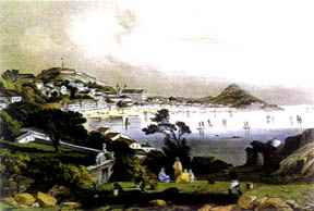
VIEW OF MACAO FROM THE MONTE FORT NEAR ST. PAUL'S CHURCH
[?] MEDELEY
1840. Coloured litograph.
Museu de Arte de Macau (Macau Museum of Art) Collection
CHAPTER IV
MACAO FACES THE FOUNDATION OF HONG KONG AND THE POLITICAL AND ECONOMIC TRANSFORMATIONS IN THE REGION AND IN THE WORLD
§ 1. THE END OF MACAO AS THE POLE OF COMMERCIAL EXCHANGES BETWEEN CHINA AND THE WEST
The opening of the ports of China to the West and the establishment of the British in Hong Kong had decisive repercussions on the evolution of Macao from the nineteenth century onwards.
The Convention of Chuenpi which terminated the Opium War between Britain and China was ratified by the Treaty of Nanjing in 1842. The 'opium question' had existed since the seventeenth century and the revenue from the commercialisation of this product was of considerable importance to the economies of European countries, particularly Britain, and the economy of Macao. Official Chinese legislation had always forbidden the import and consumption of opium and in 1838 a Chinese Imperial Decree expelled all British subjects from the country and the port of Guangzhou was closed to British Companies. By 1842 the conflict had been solved in favour of the Britain who demanded the payment of reparations from China, obtained the immediate opening of the ports of Guangzhou, Amoy, Fuzhou, Shanghai and Ningbo to European trade and also obtained the cessation of land for the installation of a commercial establishment. In 1843 the territory of Hong Kong was ceded and the British founded the city of Victoria.
For Macao the end of the long period of three centuries in which the territory was the only commercial emporium between China and the West was on sight. Replaced by Hong Kong, Macao suffered the consequences of the international conjuncture, accentuated by the rapid growth of the British nucleus. The foreign Companies established in the Portuguese city were attracted by the dynamism of the new emporium which had a large harbour. In 1845 the British consulate in Macao was closed and the European and American commercial and diplomatic representations followed suit. Some stayed on for a few years, using Macao more as a diplomatic than a commercial centre, and in 1844, the Sino-American Treaty was signed in the city, in the Kun Ian Temple.
The Estrada de Cacilhas (Cacilhas Road) near the Centro Hospitalar Conde de São Januário (St. January's Government Hospital).
In the distance, the Capela de Nossa Senhora da Guia (Chapel of Our Lady of Guia) and its adjacent lighthouse - the first in the China coast -crown the Colina da Guia (Guia Hill).
RC Photographic Collection.
The foreign Companies took with them many of their Macanese officials and the latter were fundamental in the formation of the commercial and cultural structures of Hong Kong. These officials served as interpreters in contacts with the Chinese. Many merchants from Macao, who traditionally operated in the region and were acquainted with the dynamics of the complex process of relationships, also moved to the British city with their families. Others joined the banks and insurance companies established in that port and some supported the incipient cultural structures. In the nineteenth century there were large numbers of Macanese in the city of Victoria.
The British emporium supplanted Macao not only in the business of importing Chinese products and manufactured goods but also in the placing of Western products in the region. The Portuguese city thus passed from a privileged situation to one of dependence. A shipping line (first sail, then steam) was organised between Hong Kong and Macao for the transport of passengers and goods. Communications were perfected in new fields supported by modern technologies and in 1920 the telegraph was inaugurated between the two cities. For Macao the connection with Hong Kong signified an approximation to European standards and life styles.
The regulations of the city and the port of Macao, approved in 1842, reorganised the old methods of operation, adjusting them to the conditions arising from the opening of other ports on the Chinese coast, in addition to Guangzhou, and did not anticipate the consequences of the establishment of Hong Kong. Macao was only designated a free port in 1845, a late measure for by that time the British port was already equipped and operating, attracting foreign capital and the ships of the great European and American lines.
Although the immediate consequences of the foundation of Hong Kong were catastrophic the economy of Macao sought to adjust to the new equilibrium in the region where to the present, the new centre has reigned supreme. Trade in coolies and opium were the basis of the territory's economy in the nineteenth century which were later joined by the first modern industrial structures.
The Hotel da Bela Vista (Bela Vista Hotel) shortly after its innauguration in July 1890.
Underneath the imposing structure of the former private residence are the simple structures of the Fortaleza de Nossa Senhora do Bom Parto (Fortress of Our Lady of Safe Delivery) garrison and the remnants of the original protecting ramparts.
§ 2. RELATIONS BETWEEN THE CHINESE AND PORTUGUESE SOVEREIGN POWERS IN MACAO
The implantation of liberal constitutionalism in Portugal after 1834 originated structural transformations of the political, administrative, juridical and commercial regime which affected the colonial territories.
The most important measures in this area were:
--the revision of the colonial administration leading to the centralisation of power and the effective affirmation of Portuguese sovereignty,
--the organisation of the provinces and the extension of the municipal regime to all territories, and
--the abolition of the religious Orders with the consequent secularisation of their possessions which were transferred to the state and institutions or sold to private entities.
In 1844 Macao was separated from Goa and became a province which included Timor and Solor. The territory remained in this administrative situation until 1850 when two independent provinces were formed. After 1870 the Province of Macao and the Province of Timor were permitted to elect two deputados (Deputies) to the Cortes (National Assembly). The history of these two territories is interrelated in the nineteenth century for administrative and economic reasons. On some occasions they made a joint contribution to the revenues of the general budget of the kingdom.
Portuguese colonial policy was based on the European models of the period and the affirmation of sovereignty by military occupation became a priority. The Governors of the Províncias Ultramarinas (Overseas Provinces) or Colónias (Colonies) were systematically military personnel and to make them more effective as occupying forces they were provided with additional land and sea forces. João Maria Ferreira do Amaral was the first Governor to implement the new policy in Macao. He governed from 1846 to 1849 and prepared a series of measures designed to extend Portuguese sovereignty over the whole of the territory, from the Portuguese city to the Chinese fields and villages. He expelled the Chinese Customs from the city, abolished the payment of ground-rent for harbour anchorage duties, occupied the Ilha da Taipa (Taipa Island) and the Ilha de Coloane (Coloane Island), fortifying the former with a defensive system and established a plan for improvements in the city and fields between the old limits of the Portuguese wall and Border Gate.
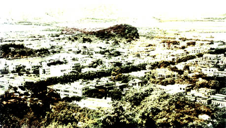
North-northwestern panoramic of the peninsula of Macao taken from the heights of Colina da Guia (Guia Hill).
The mountains in the background are the mainland of China.
In the left, the Fai Chi Kei district before its radical transformation shaped by the major alterations of the Inner Harbour; in the right, the Iao Hon district, before its vast urban development.
RC Photographic Collection.
While the Governor power increased considerably, supported by military structures and juridical force, the influence and functions of the Senate were reduced to the statute of a Municipal Council with no diplomatic representation at local level. The reactions of the Chinese authorities and of the Senate to Ferreira do Amaral's forthright measures were immediate. As a result of local tensions the Governor was assassinated and Portuguese troops advanced beyond the Border Gate to Pak-Sha-Leng in a demonstration of force to Chinese authorities and troops, an episode which became known as the Victory of Passaleão in the Portuguese version of the events. These actions resulted in the extension of Portuguese dominion up to the Border Gate where, in 1871, a monumental arch was built to replace the old Customs Post. The inner Chinese settlements and those on the outskirts of the Portuguese City such as the Bazar Novo (New Bazaar), Patane, Chunambeiro, Barra and Manduco Beach, and the Macanese suburb of St. Lazarus became extensions of the urban area. Other Governors implemented effective measures for the extension and development of the territory according to the standards and models of the time, such as Coelho do Amaral (1863-1866), Viscount of São Januário (1872-1874), Horta e Costa (1884-1897 and 1900-1904), Carlos da Maia (1914-1916) and Tamagnini Barbosa (1918-1919, 1926-1931 and 1937-1940).
The Church which had been up to then an important share in the division of powers had its sphere of activities reduced with the extinction of the religious Orders in 1834. The Friars and Nuns were expelled and became secular individuals, their properties being confiscated and the churches and monasteries expropriated and occupied. A large part of the Convent of St. Francis was demolished and turned into barracks in 1851 and the gardens and vegetable gardens became public grounds. The Convent of St. Clare, nearby, was also destroyed and used for other purposes while in 1867 the police force was installed in St. Dominic' s Convent within the city. The remaining religious structures were maintained and in 1856 the old Colégio de São José (St. Joseph's College) of became a diocesan seminary. The Diocese, represented by the Bishop, became the sole representative religious entity, the See being completely renovated in 1850.
The grave of Camilo Pessanha in the Cemitério de São Miguel (St. Michael's Cemitery).
The paired Chinese (chiselled in red, in the vertical slab) and the Portuguese (chiselled in black, in the horizontal slab) epitaphs are a humble hommage not only to the great poet but to the mixed community which he so much loved and wrote about.
The Portuguese inscription reads:
To the Dear Memory of / the Poet/Dr. Camillo Dalmeida Pesssanha [Camilo de Almeida Pessanha] / João Manoel d' Almeida Pessanha [The poet's son] /Born on the 21st of November 1867/Dead on the 30th of July 1926/An Hommage from his Son.
Nineteenth century colonial models have formed the basis of government structures up to the present day and the territorial limits and the ambient of the Portuguese sovereignty were established at that time. The council organisation covered the islands which later became independent conselhos (councils) with their own characteristics and administration. The remaining institutions and organisations such as judicial, commercial and Customs Tribunals, Revenue Offices and the Port Authorities were also reorganised to adapt to centralised government.
The changes brought about by the establishment of Hong Kong and the measures leading to the affirmation of Portuguese sovereignty modified Chinese activity in Macao. The Chinese Empire had been defeated in the Opium War and was military and diplomatically weak. In addition, Macao had ceased to be economically important as economic activities were progressively transferred to the British territory. The history of China in the nineteenth century is characterised by successive periods of internal instability which led to the downfall of the Empire and the installation of the Republic in 1911. There were also external crisis in the form of conflicts leading to the Sino-Japanese War in 1894 and the Boxer's Rebellion in 1900.
The affirmation of Portuguese military supremacy and the extension of sovereignty to the whole territory and islands in 1849 gave rise to tension between the two countries and provoked local disagreements as each party claimed rights over those areas. The mandarin administration wished to continue its intervention in the Chinese fields and villages and the Portuguese city, while the Portuguese government occupied the whole of the territory up to the Border Gate.
In 1862 Portuguese diplomacy established a first accord regarding the co-existence of the Chinese community under Portuguese sovereignty and obtained authorisation to open an official Portuguese consulate in Fuzhou. Negociations culminated in the Treaty signed between the two parts in 1887 which established the statute of Macao.
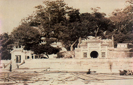
The retaining wall of the Mage miao (Ama Temple) with the main access gate to the temple precint, on the extreme left.
In the foreground Chinese fishermen repair a sampan sail in the recently reclaimed area from the Porto Interior (Inner Harbour).
Photograph taken in 1903-1904 by F. E. de Paiva.
In: PAIVA, F. E. de, Um Marinheiro em Macau - 1903 (Álbum de Viagem), Macau, Museu Marítimo de Macau, 1997, p.101.
Macao was then defined as a Portuguese possession as any other colonial territory, but with one particularity which anticipated and recommended consultations with China in relation to all and any situation of territorial alienation or other modifications that affected the region directly or indirectly. Some questions such as sovereignty over the Island of Lappa, the Island of Dom João and the Mountain Island, that been occupied by the Portuguese and abandoned in the eighteenth century, were never clarified. In practice, Macao retained the Island of Taipa and the Island of Coloane and China the remainder, a de facto situation that was only recognised juridically and diplomatically in later agreements in the twentieth century. On the peninsula of the monumental arch at Border Gate, inaugurated in 1871, became the physical and Customs boundary of the territory.
Macao did not intervene in China's internal or external policies and always maintained a strict neutrality during conflicts. In 1904 neutrality was expressed and publicly declared in the Japan War that only terminated with the peace Treaty signed by the two countries involved, in 1928. In the first years of the Portuguese Republic, founded in 1910, and the newly born Chinese Republic, tensions were gradually relaxed and in 1928 the road from Macao to Seak-ki was inaugurated, linking the Portuguese territory with the villages on the estuary of the Pearl River.
The problem of Chinese emigration through Macao originated some tension but was finally resolved under pressure from the Chinese authorities. Although the abolition of slavery in Portugal dated from the eighteenth century, it remained for nineteenth century liberal and the new Código Penal (Penal Code) to extend this legislation to the colonies where slavery still existed in diverse forms. This process was rapidly replaced by the contracting of labour against payment of wages which, in practice, was a kind of purchase. Through Macao labour was supplied for contract periods at low prices and in deplorable conditions for the Portuguese colonies of Africa and Brazil, as well as for South America and the Antilles. In 1856 Chinese emigration from the territory was regulated. The Chinese Proclamation of 1859 on emigration led to a revision of the problem and resulted in the creation of a Casa da Superintendência dos Cules (House of Superintendence of Coolies), in 1868, which operated until the prohibition of emigration by local inhabitants, specifically coolies, and the total abolition of the emigration of foreigners through Macao, decreed in 1784. The contracting of Macanese for the Portuguese colonies of the African coast, however, continued for several years.
The local communities were essentially composed of Portuguese and Chinese and a considerable number of Macanese resulting from the miscegenation over the centuries. The Chinese ethnic group was the most numerous and maintained its own cultural systems expressed in its language, religion and houses. In 1863, a Chinese language weekly paper "Ta-Ssi-Yang-Kuo" ("Archives and Annals of the Portuguese Far East") commenced publication. The Portuguese population consisted of administrative and defence personnel and their families.
A broken stone slab with the coat of arms of Portugal
-an escutheon with nine castles surrounding a central coat of arms with five shields and a lying on the of the Casa Garden, Macao.
Photograph taken in 1989 by José Simões Morais.
Language was a barrier in contracts between the two communities and in 1868 the Portuguese government created a group of Chinese language interpreters to support the administrative authorities. There were, however, no measures which would lead to the enforced cultural indoctrination of either of the parts. Side by side with the coexistence of different ethnic and racial groups there were slow, profound, cultural exchanges which produced cultural and behavioural manifestations and forms of expression and influenced the architecture and organisation of the city.
§ 3. NEW ECONOMIC DEVELOPMENT AND THE EXPANSION OF THE CITY
3.1. FACTORS OF ECONOMIC DEVELOPMENT
After the foundation of Hong Kong this port began to compete with Macao which, located in the lower regions of the Pearl River, experienced difficulties in receiving large ships. Buth althought it lost as a port, the territory experienced a period of prosperity linked to commerce in coolies and contraband opium the greater part of which was processed in the Hebo of Praya Grande.
In fact Macao became an important centre for Chinese leaving for America. The first wave of emigrants dated from 1848 and was destined for New California where gold had been discovered.
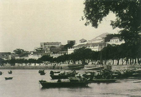
A view of the Praia Grande (Praya Grande) waterfront promenade.
On the foreground, Chinese tanka boats; on the middle ground, remnants of the St. Peter's Bulwark (Baluarte de São Pedro); and in the background to the left, the rooftop of the Igreja de São Lourenço (St. Lawrence's Church).
Photograph taken in 1903-1904 by F. E. de Paiva.
In: PAIVA, F. E. de, Um Marinheiro em Macau -1903 (Álbum de Viagem), Macau, Museu Marítimo de Macau, 1997, p.25.
As destinations, Cuba and Peru followed in importance.
In 1855, and as a result of the proportions assumed by this hiring of labour and pressures from abroad and from the Jesuits against this form of slavery, the government prepared a series of regulations for the contracting of coolies, the latter being strictly limited in number in 1873, an attitude which benefited the British of Hong Kong where this type of commerce was originated. Although the government of Macao controlled the coolie warehouses the trade was dominated by foreigners. Montalto de Jesus (Historic Macao ??, 1902, p.382) referring to the nationality of the ships calling at Macao to load this Chinese labour noted, in 1857, fifteen British, six French, 5 Italians, 3 Peruans, two Americans, one German, one Salvadorean and thirteen belonging to Macanese ship owners.
Cuba was the largest centre for the settlement of coolies followed by Peru (Lima) and Demerara. Colies trade, which enriched the local population, was processed in Macao in establishments located in the Street of the Fishermen, Rua do Gamboa (Gamboa Street), St. Lawrence's Street, Rua da Praia Grande (Praya Grande Boulevard), Travessa da Palanchica (Palanchica Alley), St. Anthony's Square and Hospital Street.
In addition to traffic in coolies and contraband opium, tea was important as an export product for Kong, Guangzhou, Batavia, Goa and Portugal.
The monopoly of gambling (1886) also produced revenues but when tea import markets closed and the export of coolies was forbidden Macao entered a period of economic decadence. It only managed to survive thanks to the opium trade which was carried out on a large scale througout the East, notwithstanding the existence of a regulation which forbade the culture and commerce of this product.
3.2. POPULATION: GROWTH AND STRUCTURE
In 1841 Macao had about twenty-five-thousand inhabitants, twenty-thousand of whom were Chinese. The census of June 1867 indicated a total of sixty-six-thousand two-hundred and fifty-two inhabitants which signified the duplication of the resident population. The areas of great concentration were the Catholic city (twenty-thousand one-hundred and seventy-seven) and the Bazaar (fifteen-thousand five-hundred and seventy-three). Patane (eight-thousand four-hundred and eighty-one) and Mong-há (eight-thousand one-hundred and eighty-two) followed, whereas, in the quarters of St. Lazarus (two thousand five-hundred and ninety), Tanque-Mainato (five-hundred and thirty-three) and Barra (one-thousand seven-hundred and sixteen), only Chinese resided. The increase in this population was due more to emigration than to natural growth and about 96% originated from the province of Guangdong, 3% from Fujian and 0, 12% from Guangxi and the remainder from Hong Kong and Shanghai.
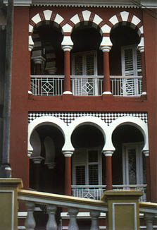
Calçada do Gaio (Gaio Alleyway), no 6 - overlooking the Jardim Vasco da Gama (Vasco da Gama Garden).
The astonishing neo-Moorish townhouse was one of the several incredible Islamic revival projects built in the Portuguese Colony during the Twenties and Thirties.
It presently houses the Instituto de Estudos Europeus (Institute of European Studies).
The results of the 1878 Census, which was more accurate, are not comprarable with the earlier one as the variables and the areas to which they refer are different. However, it is possible to verify that in eleven years the total population increased by 6.2%. In area the positive variations of more importance were registered in the parishes of St. Lawrence's (two-thousand one-hundred and eighty-nine) and St. Lazarus (eight-hundred and sixty-six), while the greatest losses occured in Bazaar (minus five-thousand five-hundred and thirty-four), Mong-há (minus three-thousand two-hundred and forty-eight) and See (minus (two-thousand seven-hundred and sixty-seven). As regards the distribution of the population inside the city, the greater number of European resided in the See (two-thousand two-hundred and seventy) and in St. Lawrence's (one-thousand three-hundred and forty-three). The latter parish, Bazaar and Patane had large numbers of Chinese who represented 72.7% of the total population of this group living in house-boats (ten thousand and sixty), that is, almost a fifth of the total.
Represented in the three principal parishes - See, St. Lazarus and St. Lawrence's - the Portuguese had occupations in the area of services while the Chinese traded and worked in small artisan industries.
Although the number of undeclared professions forms a significant part of the total, preventing a greater degree of accuracy in the interpretation of results, it is possible to verify that administrative and military personnel were present in the parish of See. They were also well represented in St. Lawrence's where property owners and their servants predominated, denoting the residential character of this area. The Portuguese residing in St. Anthony's and St. Lazarus had a wide variety of professions while among the Chinese population, although the tertiary sector was predominant, the secondary sector was also represented.
Connected with the latter were 17.2% of active Chinese resident in St. Anthony's and 8.9% in St. Lawrence's, contrasting with 2.4% and 6.0% respectively, in See and St. Lazarus.
At the beginning of the nineteenth century (1910) the total population of Macao was sixty-five-thousand seven-hundred and thirty-three, the Portuguese having decreased by nine-hundred and five inhabitants and the Chinese increased from fifty-five-thousand five-hundred and forty in 1878 to sixty-one thousand seven-hundred and thirty-two. St. Anthony was the parish with the largest population increase (two-thousand seven-hundred and forty-eight) and, as in Mong-há, the increase occurred among both Portuguese and Chinese. The populations of St. Lazarus and See decreased between 1878 and 1910 by one-thousand six-hundred and fifty-eight and one-thousand four-hundred and fifty-nine respectively. The number of inhabitants per house also diminished in these parishes from 5.0 and 6.0 to 4.04 and 4.35 respectively. In Patane and Mong-há and the house-boats of the Inner Harbour, however, this variable rose due to the increase in the Chinese population.
As regards the professions of the Portuguese population, the parish of See showed an increase in individuals active in commerce while administrative officials and military personnel were more numerous in St. Lazarus.
Although it was considerably diversified, the professional structure of the parishes of St. Lazarus and St. Anthony's was dominated by the tertiary sector which was also well represented among the Chinese population. The latter parish was also less important than in the previous period as regards the percentage of people active in industry (3.1%), and was surpassed by Patane which, considered individually in this census, had 4.8% of its population active in the secondary sector.
Details of two buildings in the Avenida Almeida Ribeiro (Almeida Ribeiro Avenue).
The revivalist concrete columns of the entrance portico of the headquarters of the Correios, Telégrafos e Telefones [CTT] (Post Office, Wireless and Telephones), built in 1931, in sharp contrast with the minimalist geometric elevations of the Bank of China, built in the late Eighties.
Photograph taken in 1999 by José Simões Morais.
Maintaining an identical spacial and economical structure, the total population increased by 13% between 1910 anmd 1920 in the areas of See, St. Lawrence's and St. Anthony's registering the greatest increases. The variation in density of the urban population, which in that period increased from 138.6 inhabitants per hectare to 155.5, was probably due to the latter area.
3.3. DEVELOPMENT AND OCCUPATION OF THE CITY
The expansion ar recession of the urban population corresponded to the political and economic fluctuations of the period.
During the government of Ferreira do Amaral a modern road network was laid out, linking the city to the villages and the Chinese territory between the isthmus.
Some of these roads followed old thoroughfares. Connections were thus established between St. Anthony's Gate and Border Gate, and between the latter and Mong-há, extending to the [Velho] Pagode ([Old] Pagoda; or Kung Yam Ku Miu (Chin.)) the Border Gate. The construction of roads provoked reactions from the Chinese population which traditionally occupied large areas with cemeteries which were sacred, untouchable places. The works proceeded and in 1849 a site was established for a Chinese cemetery between the wood of Mong-há and the Novo Pagode (New Pagoda; or Kum Yam Tong (Chin.)). To make the occupation of the Chinese fields and villages effective, new fortifications were built, some for land defence, others for the sea. The most important defense structures were the Forte de Mong-há (Fort of Mong-há), the Fortaleza de Dona Maria II (Fortress of Dona Maria II) and the Bateria Primeiro de Dezembro (First of December Battery). At the ame time the old fortifications were renovated and modernised.
To contain the progressive intermingling of the Portuguese urban area with the Chinese centres and define boundaries, a control gate was built in Patane adjacent to the harbour. Within the city some civil and religious buildings were renovated and buildings and houses were numbered. To legally support and expedite the transfer of properties from the Chinese community to the Portuguese, legislation was published exempting from tributes and taxes the private land and buildings purchased from the Chinese.
In 1850 the area between the Rua do Seminário (Seminary Street) and the Manduco Beach was earth filled. Until then the sea front, which corresponded to the present Manduco Beach Street, as occupied by dispersed buildings inhabited by Chinese artisans and traders connected with maritime activities. After the earth-works in this area, which became part of the city, the parallel streets, perpendicular to the sea, housed a Chinese population engaged in commercial and artisan activities.
The activities of the Chinese were concentrated in the area of the Bazaar and the Inner Harbour, the latter having a large number of haos. Of a total of forty establishments, thirty-four had their headquarters in Macao and branches in China, Cochin-China, Siam, Singapore and Pirany. The remainder were brances of the haos established in some of the above mentioned locations. And they constituted the most important units of Chinese commerce. The latter was generally represented in the Bazaar by associations which in their various forms were the fulcrum pof city life. After the reinforcement of Portuguese sovereignty Macao enjoyed complete stability during the government of Coelho do Amaral and urban improvements were carried out. A road was built linking Macao to the Border Gate, the boundary walls were prolonging the latter being demolished; rules of municipal government were drawn up; street paving was improved; the Chinese quarters were provided with infrastructures and the surrounding areas were adapted to urban expansion. An important improvement during this period were the earth-works between Praya Grande and the Bom Parto Fortress. The work in the territory continued under Coelho do Amaral's successor, the Viscount of São Januário, who ordered the execution of the first phase of the earth-works along the shoreline of the Inner Harbour and the regulation of the river flow from the Fortress of St. James of Barra to the Mong-Tchoi dock; provided the streets adjacent to the Bazaar with water and draining systems, and ordered earth-works to be carried along the coast from the Bom Parto Fortress to the chácara of Maximiano António Remédios on the Barra side. These works retained the curtain wall which still exists today.
Also prominent in this period was the activity of engineer Adolfo Ferreira Loureiro whose study of the Inner Harbour resulted in the regulation of currents, earth-works, the construction of new docks and land reclamation between Green Island and the Macao peninsula. As was the custom in European harbour areas, Adolfo Loureiro's plan included housing in the isthmus area for the port workers but this plan was not executed. This housing project included blocks forty metres in depth separated by streets twenty metre wide, and an avenue with trees to the North. Works in the Inner Harbour were concluded in 1921 but at the end of the century improvements in Macao were not restricted to the ports.
After 1848, when Governor Ferreira do Amaral reasserted Portuguese sovereignty over the areas extending from the Catholic city to the Border Gate, the problem of sanitation in this area had to be considered. Public opinion clamoured for sanitation in Mitra (Mitre) and Volong (Volong), the San Kiu Ha channel and the plains of Mong Ha. The first which had a population of sixty-thousand inhabitants and was located next to the civilian hospital, was replaced by the Tomás Rosa housing project, designed to a ectangular plan, where rules of expropriation and sanitation were imposed. The lands of Volong, with an area of approximately two-hundred hectares, were expropriated for public use in 1894 and handed over to the Senate which had roads built and water and drainage systems installed by the Departamento das Obras Públicas (Public Works Department). The St. Lazarus quarter was given the same treatment, the sanitation works dating from 1900.
The governments of Horta e Costa (1894-1897, 1900-1904) undertook the sanitation works of Tap-Siac, Sá-Kong and Mong-há. In July 1901 the buildings and huts of Mong-há were declared of public utility and were expropriated and the Public Works Department prepared a project for the cleared area. This included the construction of the future Avenida Horta e Costa (Horta e Costa Avenue), which started near Rua da Flora (Flora Street) and connected with a roundabout, the Praça Carlos da Maia (Carlos da Maia Square), from which opened other avenues crossing the Mong-há plains. During the governorship of Horta e Costa the Avenida Vasco da Gama (Vasco da Gama Avenue) and Avenida da República (Avenue of the Republic) were constructed and part of the Rua do Visconde de Paço d'Arcos (Viscount of Paço d'Arcos Street) was earth-filled.
Decorative panel in the Lou Lim loc Gardens, Macao.
The first years of the twentieth century, still favoured by a certain degree of financial prosperity, saw the elaboration of a plan for the general sanitation of the city, decreed in January 1905. For the implementation of this project, houses and huts were expropriated in 1913 in Patane, Rua Coelho do Amaral (Coelho do Amaral Street), and the extensions to Rua Adolfo Loureiro (Adolfo Loureiro Street) and Estrada do Repouso (Rest Road). In 1915 work was started on the construction of Almeida Ribeiro Avenue and earth-works in the São Miguel (St. Michael), Mong-há and Long-t'in-Tchin areas. In 1918, after expropriation of the various houses of Senate Square and Travessa do Roquete (Roquete Alley), the Almeida Ribeiro Avenue was linked to the Praya Grande Boulevard. A year later the Rua de Entre Campos (Entre Campos Street)and the Street of the Fishermen and the shore Estrada da Barra (Barra Road) were widened. In 1924 the Estrada do Porto Interior (Inner Harbour Road) between Praça do Pagode (Pagoda Square) and the Praça da Barra (Barra Square) was widened. The area of the city almost doubled and this expansion was accompanied by the publication of the first Regulamento dos serviços das obras particulares e de salubridade das edificações urbanas da cidade de Macau (Regulations of the Services of Private Works and the Salubrity of Urban Buildings in the City of Macao).
Simultaneously various social structures were installed which improved life of the Macanese, for example, the inauguration in 1894 of the Liceu Nacional de Macau (National Liceum of Macao, or Secondary School of Macao) which was installed in the St. Augustin's Convent; the inauguration of an airline, Macao Aerial Transport Company Ltd., in 1920; the commencement of the operations in 1924 of the Central Rádio de Macau (Radio Centre of Macao), property of the Radio Communication Company, provisionally installed in the Fortress of Dona Maria II.
Between 1925 and 1928 the Hippodrome was opened to the public and Patane dry-dock and the roads from Macao to Seak-Si were inaugurated.
The Building of Caixa Escolar (School Trust) was inaugurated in the street of the same name, as were the fair and trade exhibition to promote the new Outer Harbour, and the Hotel Presidente (President Hotel), now Hotel Central (Central Hotel), at that time the highest building in Macao. In the new areas scattered dwellings began to appear and at the end of the nineteenth and beginning of the twentieth century the area of Cacilhas Beach and that between the Avenida Marginal do Patane (Patane Waterfront Avenue) and the hermitage of Our Lady of Penha de França began to be occupied, the former summer houses including that of the government, the latter by chácaras belonging to a middle class enriched by trade and gambling.
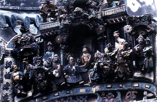
Glazed terracota figures in an ornamental panel in the Kun Iam Temple.
Arquivo Histórico de Macau (Historical Archive of Macao) Photographic Collection.
As regards the functioning of the city, study of the Anuário de Macau de 1924 (1924 Macao Year Book) revealed the existence of four centres of commerce and services. One predominantly commercial and belonging to the Chinese, extended from Praça de Ponte e Horta (Ponte e Horta Square) to Calçada do Botelho (Botelho Alley) and from Rua das Lorchas (Lorchas Street)and the Viscount of Paço d'Arcos Street to the Senate Square and Straw Street. The boundaries to the North were Rua dos Fatiões (Fatiões Street) and Tercena Street and to the south Rua do Gamboa (Gamboa Street) e Calçada do Gamboa (Gamboa Alley). This generally corresponded to area of the Chinese Bazaar. Here there was a predominance of foods shops (numbering seventy five), clothing and knitwear (numbering thirty eight) and restaurants and eating houses (numbering twenty nine). The former were more concentrated between the Fifth of October Avenue and Viscount of Paço d' Arcos Street, while clothing and fabrics were more frequent in the Street of the Inns, the Street of the Merchants, Camilo Pessanha Street and Straw Street. Although well represented throughout the area, there was a larger number of restaurants in Aterro Novo (New Reclamation Zone), the Rua da Felicidade (Street of Happiness) and Rua do Pagode (Pagoda Street) and the Southern ends of the Fifth of October Avenue and Guimarães Street. On the periphery between the Street of the Fishermen and Rua do Teatro (Theatre Street) were junk shops with a sprinkling of hardware shops and small industries. This type of establishment also extended to Rua do Patane (Patane Street. The South-Eastern end of Almeida Ribeiro Avenue, between the Pray a Grande Boulevard and Senate Square had a considerable concentration of services and could be called the economic centre of the period. Here was to be found the largest number of Exchange Bureaux (thirty six), large hãos (Port. transliteration) (four) and a branch of the Banco National Ultramarino (National Overseas Bank). This complex was connected to Central Street forming another area of commerce and services. Formerly known as Straight Lane, it had commercial establishments which extended up to Praça de São Lourenço (St. Lawrence's Square). These served the European population (tailors, china [wares], fabrics, foodstuffs, barbers, jewelers and watchmakers). This type of establishment extended Rua do Campo (Campo Street) along Rua Nava da Guia (New Guia Street).
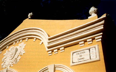
Public Works Building adjacent to the Igreja do Carmelo (Church of the Carmel), Taipa Island.
Photograph taken in 1998 by Joaquim de Castro.
The limited number of establishments (twenty five) constituted a small nucleus separated from Central Street by large blocks of buildings bounded by Rua de Pedro Nolasco da Silva (Pedro Nolasco da Silva Street), Travessa dos Anjos (Angels Alley) and Formosa. From concentration of establishments in the first of these streets it was clear that in future it was to become an extension of the Chinese Bazaar.
The third centre of commerce and services extended from the Manduco Beach Street to Rua do Almirante Sérgio (Admiral Sérgio Street). With a predominance of food shops, ironmongers, fabric shops and eating houses, the interest of this area lay in the existence of industrial establishments which although artisan in character were important within the city complex. This functional area was easily identified in the urban structure by a network of narrow parallel streets built on new earth-fill, perpendicular to the sea and bounded to the West by the old Manduco Beach. Finally between Coelho do Amaral Street, Rua da Pedra (Stone Street) and the Street of Happiness there was a further concentration of activities with a significant number of china and hardware shops. But of greater importance was the concentration of industrial establishments which corresponded to 44.4% of the total units installed in the city.
3.4. PORT WORKS AND IMPROVEMENT PROJECTS
The transformation of the old colonial structures in the Portuguese city became of prior importance in the process of nineteenth century progress. The policy of regeneration defined in the 1850's also extended to the large Colonies. Communications, road networks, basic sanitation and large public works were the principal fields of action. The organisation of Public Works Department in the Colonies in 1869, with the establishment of local delegations, favoured this type of intervention and provided efficient technical support. The first action undertaken by the government of Ferreira do Amaral [1846-1849] was the transformation of rural roads into modern streets. The question of the old harbour structures was also considered and the opening of new ports along the coastline of the peninsula and islands. In 1864 studies were initiated for harbour improvements, the responsibility for which was given to the Serviço de Obras Públicas no Ultramar (Overseas Public Works Department) within the ambit of the Ministério da Marinha (Ministry of the Marine) with technical personnel provided by the latter. In 1865 a lighthouse was installed in the Guia Fort to aid shipping. Regularisation of the shores of the Inner Harbours was concluded in 1881, thus finalising the progressive occupation of the Baía da Praia do Manduco (Manduco Beach Bay) and Baía da Praia Pequena (Praya Pequena Bay). This project included a waterfront road that encompassed the whole of the peninsula and later joined up the Praya Grande Boulevard after the occupation of the Baía do Chunambeiro (Chunambeiro Bay) and Baía do Bispo (Bishop's Bay).
The first project of harbour works, large scale and with far-reaching consequences from the urbanistic point of view, was by Adolfo Ferreira Loureiro, an engineer of the Public Works Department, native of Lourenço Marques [presently Maputo], who had worked on the port there. Interested in the question of sedimentary deposits he prepared a preliminary project based on a hydrographic map of the mouth of Pearl River delta and the Inner Harbour. According to this, the Northern channel of the delta's mouth would constitute the main access to the Inner Harbour, the Southern channel becoming redundant. As the Western arm of the Pearl River carried the greater quantity of sediment, the preliminary project included a dike which diverted its waters and was connected with Taipa Island.
The need to simultaneously resolve the problem of the Outer Harbour and a connecting channel between the two, which was only constructed in 1911, was also included in the project.
Although without immediate and total consequences the idea of the remodeling of the Inner Harbour connected with the construction of the Outer Harbour on the Western arm of the Pearl River delta, and other smaller ports on the [Taipa and Coloane] Islands, and construction on future reclamation areas, took root. Other proposals were prepared and partially implemented, such as the project by engineer Abreu Nunes (1903) for the final works of the mooring sea-front wall from Barra Fort to Green Island and the later studies by engineers Vasconcelos Porto (1908), Santana Castel-Branco and Hugo de Larcerda.
These plans were abandoned as not economically viable and were followed by others, all for the Inner Harbour and Green Island.
In 1918 the Missão de Melhoramentos dos Portos de Macau (Mission for Improvement to the Harbours of Macao) was created to give immediate effect to the works of the Inner Harbour. This plan, which altered Castel-Branco's project of 1912 for political reasons, did not include the reclamation to the North of Green Island, that of Praya Grande or the moles of Patane's dock. The harbour was to be established adjacent to the Southern channel of the Western arm of the Pearl River delta. This was equally impossible to implement, both politically and economically, and other projects were prepared in 1919 and 1920, as the rapidity which drainage occurred made it essential to advance with the sea harbour. The contract was awarded to the Netherlands Harbour Works company and work on the Inner Harbour began in 1923.
Up to that date work on the Outer Harbour had been limited to the installation of moles for Border Gate to Barra, the main port being destined for the shipping lines. A harbour in Areia Preta (Black Sands) was built, to the North and to the West new docks and further reclamation being considered for the future.
Throughout 1923 projects were prepared for the widening of the shore quay South of Ponte e Horta Square and for the pontoon between the Northern basin of Patane and Green Island. With the project of the new harbour at Black Sands the harbour of Praya Grande was put aside while additional work on the Baía da Areia Preta (Black Sands' Bay) was completed in 1925. The large volume of works carried out by the Netherlands Harbour Works company was effected between Praya Grande and Macau-Seac.
These works on the harbour of Macao were carried out with a view to parallel economic development and the establishment of links with the interior. However, these dreams did not come true. In spite of labour costs, Macao never attracted large scale investments and found it difficult to compete with the business acumen and dynamic of Hong Kong which benefited from the statute of 'free port'. For political reasons the road and rail links with the cities of the Chinese interior were never implemented.
3.5. THE PENULTIMATE RECONSTRUCTION OF MACAO: THE CITY AND THE NEW ARCHITECTURES
The definitive settlement of the British in China, symbolised by the foundation of Hong Kong, provided Macao with a western model which was much stronger than any it had in former periods. Although Macao had initially been the starting point for the urbanisation of Hong Kong - the ethnic division, settlement along the beach, façades in arcades - the new city and its architectures became itself a model.
The greatest manifestation of classical expression in architecture throughout the world, was produced in the nineteenth century. Exceeding the boundaries of Europe, Neoclassicism became an international style more or less adapted to local conditions but always showing a strong unity. Britain, as the head of the greatest Colonial Empire in the world, produced its most perfect models in India and then transported them to all the other Asiatic colonies. Very similar buildings appeared in Bombay, Calcutta, Hanoi, Saigon Hong Kong, Macao and the port cities of China that had closer links with abroad.
From the middle of the nineteenth century everything that happened in Hong Kong affected Macao profoundly, as evidenced by the reconstruction of the city and its expansion by means of new reclamation areas and harbour and urban structures. The new alignment of the Inner Harbour with the rectilinear coast road from the Temple of Ling Fong to the Temple of Barra, determined the creation of regular rectangular networks on the reclamation areas, with a front of buildings having straight arcades at ground level and curved arcades on the first floor. These were specially prominent in Ponta e Horta Square and clearly demonstrated a national attitude in the application of a classical expression. This mode of organising the city was not exhausted with the construction of new regular urban networks such as the Bairro da Mitra (Mitre Quarter) but was also applied to the creation of areas for recreation (Luís de Camões Garden, Jardim da Vitória (Victory Garden) and the Praya Grande Boulevard, the new cemeteries (Portuguese and Chinese), and the construction of buildings such as Barra slaughterhouse (1873), police and military barracks, the Fort of Mong-há and the Fortress of Dona Maria, the reconstruction or enlarging of churches and the erection of commemorative monuments in the more important public spaces. At the same time, and as a consequence of the government's public works policy, the city was lit with two-thousand and thirty-two oil lanterns in 1871, basic sanitation of the Bazaar was implemented in 1873 and the whole of the area between Mount Fort and Mong-há was drained.
These activities culminated at the beginning of the twentieth century with works that profoundly altered the physiognomy of the city - the construction of the Almeida Ribeiro Avenue and the urban network surrounding the Horta e Costa Avenue.
During this peak small palaces in the fashion of the 1800's began to appear, surrounded by gardens but forming part of the urban context, the first examples being the Palacete de Santa Sancha (Santa Sancha Stately House) (1846) and the Palacete da Flora (Flora Stately House) (1848), designed by the architect José Tomás de Aquino. Thus began a fashion that continued up to the beginning of the twentieth century (i. e., Casa Branca (White House) and Vila Alegre (Jolly Villa)) and had persisted almost up to the present day (the houses in Barra Hill). Many of these small 'palaces' were the property of rich Hong Kong families at a time when Macao had become the recreation ground of the British Colony. They are buildings with an urban presence and Chinese spacial structure, with arched balconies, ornaments, friezes, pediments, columns, pilasters and capitals of a classical Western origin. These Euro-Chinese houses, similar to many others in Guangzhou, Shanghai and Hong Kong, were initially constructed in traditional materials with walls and columns of brickwork and roofs in Chinese tiles, whitewashed walls, windows with Venetian blinds, fanlights in mother-of-pearl and, later, iron verandahs and reinforced concrete structures.
The most prominent public and services buildings were the Teatro D. Pedro V (Theatre Dom Pedro V), the Hospital de São Januário (Hospital of St. January), the Clube Militar (Military Club), the Quartel da Polícia Marítima (Mari-ime Police Barracks), the Hotel da Bela Vista (Bela Vista Hotel), the headquarters of the Serviços de Saúde e Assistência (Health and Assistance Services), the Esquadra da Polícia (Police Station), and the Hospital Kiangwu (Kiangwu Hospital). Forms were based on various styles from eclecticism of a classical origin to Western-type decorative revivalisms, including Neo-Chinese, Art-Deco and various exoticisms. The Portuguese Hospital of St. January, construction of which began in 1872, was based on Neo-Gothic British models and was designed by the Baron of Cereal who also designed the Cemitério de São Miguel (St. Michael's Cemetery) with its Neo-Gothic chapel (1875). The Military Club, by the same designer, was constructed in 1872, the façade having verandahs and a Tuscan-Gothic colonnade and ogival lateral windows. The Baron of Cercal also designed the façade of the Theatre Dom Pedro V (1863-1879). The building's Gothic columns and triangular pediment were added to the to the original design by Pedro Germano Marques, and inaugurated in 1859. The Maritime Police Barracks in Barra were designed by the Italian architect Cassuto and terminated in 1879, inspired by the Neo-Indian British style. It is one of the most exotic buildings in the city.
The same forms of expression were used in the façades added to existing buildings with the purpose of introducing the style of the period and modernising the image of the city. An ex-ample of this was the transformation of the old plain façade of the Misericordy to which was added an arcade two stories high, thus bringing the building into line with the new currents. The fashion for arcades, added to existing buildings or forming part of original projects became common in Macao in the buildings and commercial streets such as the Leal Senado Square and the Almeida Ribeiro Avenue, and provided a pedestrian promenade at ground level. These architectural styles of façades with arcades and verandahs were a characteristic of the urban image of the city in the commercial zones of the centre, Praya Grande, the Inner Harbour, the Horta e Costa area and, occasionally, in other areas. Practically all types of buildings acquired these façades from the large Chinese houses (i. e., Praya Grande Boulevard 83, and Campo Street 29 ) to stately houses and houses (i. e., White House, Vila Flor (Flower Villa)), since family residences (i. e., Pedro Nolasco da Silva Street 33-35, Rua Dom Belchior Carneiro (Dom Belchior Carneiro Street) 15, Estrada de Coelho do Amaral (Coelho do Amaral Road) 44, and Travessa dos Bombeiros (Fire Brigade Alley) 8) collective dwellings (i. e., Rua do Volong (Volong Street) 36) and public buildings and hotels. The arcades differed according to the forms and the materials used with thick columns, piers and pilasters in brickwork and the lighter support and guard structures in iron.
At the period Macao displayed a capacity to accept new currents from abroad and integrating these successive fashions into this permanent system of arcades and verandahs that had become Macanese.
At the beginning of the 1900's imported models provoked transformations of domestic interiors. In the well-known White House, now the Convento do Precioso Sangue (Convent of the Holy Blood), (1916) and Jolly Villa, now the Leng Nam School) (1917-1918), designed respectively by architects John Lemn and José Francisco da Silva, the interiors are very modern with sanitary installations and a certain complexity of space introduced by the importance of vestibules and staircase. The first project for Jolly Villa was much more austere and this was abandoned, the second project being in accordance with the taste of the owner who wanted the mansions of Shanghai as a reference point. The Palacete de Lu Cau (Lu Cau Stately House) and houses at Campo Street 29 and Praya Grande Boulevard 83-85, demonstrate the growing importance of the Chinese families.
All these houses have the services areas completely separate from the rest of the houses and the Lu Cau Stately House, of Western Classical architecture, was built in the middle of a walled Chinese garden, work on which was begun in 1908, where a lake surrounds the house and pavilions in an Eastern-style complex where nature and buildings intermingle.
Chinese architectural traditions continued to be seen in the city and the centres which had sprung from the old Chinese villages. Temples such as N' a Ch' a, Ku and Pau Kong in Patane, N' a Ch'a on the slope of Mount Fort and T'in Han near Macau Seac were built, restored and enlarged. The money-lenders' towers, mostly concentrated in the Bazaar were a new type of Chinese architecture that appeared in the city in the second half of the twentieth century. They were similar to other constructions of the same type on the alluvial plains of the Pearl River, having the appearance of military towers with small apertures and coping in undulated gables. They were intended to house valuables, often in the form of pledges, and were conspicuous in the area of the city facing the Inner Harbour.
The dawn of the twentieth century saw grandiose projects such as the plan for the zone of Estrada do Ferreira do Amaral (Ferreira do Amaral Road) and Horta e Costa Avenue (1900), the commencement of electrical installation and the continuation of the harbours' works which terminated in 1929. By 1905 the new docks at Patane had been completed and by 1912 the urban network of St. Lazarus and Horta e Costa had been reasonably occupied, being completely occupied in 1925. But in this newly constructed and renovated city the architectures perpetuated and adapted styles of the 1800s. The Tamagninin Barbosa social housing project and the Hipódromo (Hippodrome) was inaugurated in 1927 and the Correios (Post Office) building in 1931.
At the end of the first quarter of the century there were signs of the changes that were occurring in European and American architecture.
Some examples of fairly geometric Art Nouveau decoration, such as the façades of buildings in Almeida Ribeiro Avenue and the lateral doors of the School Trust, or the case of the more Viennese expression of the third Count of Senna Fernandes' house, now demolished, together with the appearance of Art Deco forms and the increased use of terrace roofs, were steps which prepared the way for the appearance of Modernism and the spread of 'modern expression'.
The purest examples of Modernism in Macao were built in the decade of the Thirties, extending into the Forties. The Escola Primária Pedro Nolasco da Silva (Pedro Nolasco da Silva Primary School) and the Escola Luso-Chinesa Sir Robert Ho Tung (Sir Robert Ho Tung Luso-Chinese School) are excellent examples with simple geometric lines, horizontal volumes, an absence of complex ornaments and plain painted surfaces. Revealing a strong European avant-garde influence projected through Hong Kong (i. e., the former headquarters of the Hong Kong and Shanghai Banking Corporation and the Bank of China), these works still maintain a Classical composition which denounces the influence of Beaux-Arts-type training of the architects and engineers working in the city. Many were engineers such as Canavarro Nolasco, and from the avant-gardism of European Modernism and the first proposals of the Modern movement, retained the essential values of the Imagist School and did not theoretical principles. They produced works of great quality such as the Grande Hotel (Grand Hotel) the Mercado Vermelho (Red Market) and innumerable collective dwellings, urban installations, harbour buildings, and others.
It was therefore around the Thirties that the first radical alterations to the habitual urban style of Macao began to appear. It was from that period that modern examples were built which were extensively applied thirty years later during the renovation of the city. The first hotels and housing blocks, the application of 'Shanghai plaster' (a grey conglomerate) in many buildings and the first asymmetric (almost Cubist) compositions are witness of this.
CHAPTER V
MACAO IN THE TWENTIETH CENTURY
§ 1. LOCAL HISTORY IN THE INTERNATIONAL CONTEXT
The vitality and relative expansion in which Macao responded in the nineteenth century to the appearance of Hong Kong was succeeded by a phase of paralysis and decadence resulting from the lack of dynamic support provided by the policies of the Estado Novo (New Portuguese State). The results of the inevitable connections in the regional context, particularly with the history of China, were also reflected in the territory. With the signing of the peace treaty between China and Japan in 1928, the long war between the two powers came to an end. However, the recent and short-lived peace terminated in 1937, when Japan declared war on China and invaded her territory. The most important consequence of the Sino-Japanese conflict was the transfer of a great many Chinese to Macao. During the Second World War the territory was military affected with the spread of events in the areas of the Far East and the Pacific. During this period of approximately thirty years the only changes brought about in the city were the result of projects already approved in the previous period and those already in course. Churches were altered, hospitals renovated and markets were constructed in the sanitized quarters and the new urbanised areas - the Mercado de São Domingos (St. Dominic's Market) and the Red Market (1936). The reclamation areas of Praya Grande, from 1931, and the Outer Harbour, between 1938-1946, were important as regards the extension of land in the territory but these works were the logical sequence of projects initiated at the beginning of the century. Some new and old areas were provided with statutory of a political and historical nature.
The fundamental characteristics of this period were the permanence of Portuguese structures (government, economy, church) and a constant and cautious adjustment to the internal evolution of China.
Economic and political modifications at world and regional level produced considerable changes in the territory from the decade of the Sixties.
World peace, signed in 1945, the internal and external dimension of the Chinese revolution and the development of Hong Kong as a world economic and financial centre were some of the phenomena which influenced the recent development of Macao. New industries joined the traditional ones, but it was the expansion of gambling which produced the large increase in the revenues and this has been joined by tourism.
The increase in population verified from the middle of the century, due to rural and maritime Chinese, was another decisive factor in the alteration of Macao's image. The new economic development and the demographic increase produced an urban expansion which occupied free areas and replaced old buildings, indiscriminately and without a global plan, with new blocks which were predominantly high-rise buildings. The new local hotels of Almeida Ribeiro Avenue were joined by the international hotels at the Praya Grande Boulevard, Guia and Taipa Island. The inauguration of the Casino Lisboa (Lisboa Casino) and Hotel Lisboa (Lisboa Hotel) in 1970 signified the beginning of the accelerated expansion of the phenomenon which terminated with the construction of large buildings occupied by services and sometimes habitations, providing the city with a new silhouette which extended in an almost compact form from Barra-Penha to Guia and Black Sands. In this environment of accelerated and unexpected change, Macao lives between China and Portugal in a context regional with modifications of decisive importance.
The historical transformations in China continue to have an immediate and decisive impact as the population has remained Chinese in majority. In spite of political differences and the fragility and even lack of diplomatic relations between China and Portugal up to 1974, the government of the Territory continued to represent Portuguese sovereignty but the Chinese population maintained its own cultural, educational and associative structures. The Chinese Cultural revolution had its impact in the city and there was a popular uprising in 1966. With the re-establishment of diplomatic relations resulting from the changes in Portuguese foreign policy after the 1974 coup, the question of sovereignty over the Territory was raised and negotiated in 1979, and a new statute was defined of "Chinese Territory under Portuguese Administration". Adjusting to its new profile there has been increased vigour in administration, technical refurbishment, the remodeling of old structures and the creation of new organisms. The governmental structure consists of a Governor supported by territorial offices, technical bureaux and special services. The alteration of labour legislation and direct elections for the Municipal Council were two innovations verified during 1984. The recent alteration in the internal process and Chinese economic policy and the modification of the Hong Kong statute with the signing of the Joint-Agreement between the People's Republic of China and the United Kingdom in 1984, together with the commencement of negotiations with Portugal on the transfer of the ad-ministration of Macao, will of necessity have an impact on the internal evolution of the Territory and on the region.
§ 2. THE ECONOMIC BOOM: THE IMPACT OF THE ORGANISATION OF THE AREA
2.1. THE DYNAMICS AND ORGANISATION OF THE URBAN AREA BETWEEN 1930 AND 1960
Towards the end of the Twenties (1927) the population of Macao totaled 157.157 inhabitants, 94.4% of whom were Chinese.
The political convulsions in the People's Republic of China were reflected in the population growth of the Territory and successive waves of emigrants from that country found a refuge in Macao. This migratory flow resulted in a population of 245.194 residents in 1939, a number which declined in the Forties and in 1950 was 187.772. This decrease was originated by emigration of refugees, mainly to Hong Kong and the United States of America.
The distribution of the population was altered by the rapid growth of the See and St. Anthony's parishes and the average density increased from 10.140 inhabitants per square kilometre to 15.818 in 1940 and decreased to 12.114 in 1950. This growth caused a housing shortage because construction did not accompany the rate of population increase. The buildings constructed during this period generally had two floors, the lower being used for commerce. As regards area, theses buildings reinforced the existing structure and filled the area between the Lisboa Casino and the Almeida Ribeiro Avenue and Praya Grande Boulevard.
The 1930's were a period of improvements in infrastructures and other social institutions. It was in this decade that water supply to the city was initiated (1936) and the reclamation area of the Praya Grande was implemented, inaugurated with the statue of Ferreira do Amaral in 1940. The following institutions commence operation: the Hospital Infantil de Santa Sancha (Children's Hospital of Santa Sancha), in 1934; the Hospital de São Rafael (Hospital of St. Raphael), in the Misericordy, in 1939; the Museu Luís de Camões (Luís de Camões Museum), in 1936; the Colégio do Sagrado Coração (College of the Sacred Heart), in the Ouvidor Arriaga Avenue, in 1939. The Pan American Airways terminal was inaugurated in 1937.
The urban system had already been determined in the previous period and consisted of the old Portuguese city within the walls, characterised by the religious structure and the irregular crowded streets of the Bazaar, and the Chinese villages outside the walls on which were imposed a confused orthogonal pattern reflecting an agrarian structure.
From the functional point of view the location of activities shown in the 1933 Macau Year Book gives an idea of the increased number of units in the areas identified in 1924. In addition, establishments opened in the new urban areas but they were dispersed, it being impossible to identify any structure that might correspond to a commercial and services area or centre. As regards commerce, the Grand Bazaar and Central Street had the largest concentration of establishments. The latter that was formerly devoted to activities connected with the European population, lost this characteristic due to the installation of Chinese commerce. The blocks bordered by the Almeida Ribeiro Avenue, Praya Grande Boulevard, Leal Senado Square, Central Street and Avenida do Conselheiro Ferreira de Almeida (Counselor Ferreira de Almeida Avenue) formed the services centre. Here were installed the eleven lawyers who resided in Macao, the fifty doctors, the twenty dentists and the large Hãos. The five Portuguese commercial and shipping agencies were also part of this nucleus. The small Hãos and exchange bureaux were concentrated in the Bazaar, especially in the Fifth of October Avenue and the Street of the Merchants were there were six to ten establishments corresponding to 76.1% of the total.
All the eighty-three foreign commercial and shipping agencies were also established in this area. Camilo Pessanha Street contained the largest number of tailors (15), followed by Central Street (12), the Street of the Herbalists (8) and St. Dominic's Street (2). The remaining forty-seven were located in the other streets of the Bazaar and in Rua da Barca (Boat Street) and Rua do Repouso (Rest Street).
The Bazaar was also the main centre for the sale of fabrics. The Street of the Inns being the most important as it contained 37.8% of the total sales establishments the Fifth of October Avenue with 15.5% and Almeida Ribeiro Avenue and the Street of the Merchants with 9.0%. In this nucleus were to be found thirty-three jewelers and watchmakers in the city, of which twenty-two were located in the Street of the Inns.
As in the general location model, food shops were more dispersed. Although the Bazaar had the largest number of shops, there were also several on the periphery of this nucleus, especially in the Viscount of Paço d' Arcos Street (22), Admiral Sérgio Street (16) and Street of the Fishermen (13). A significant number was also to be found in the area which extended from Central Street to the Rua do Bazarinho (Little Bazaar Street) and the Manduco Beach Street, which had a total of fifteen shops.
A further concentration of fourteen food shops was to be found in Rua da Erva (Herb Street), Boat Street, Rest Street and Coelho do Amaral Street, but the important point in this analysis is the presence of this type of establishments in Black Sands (3), Horta e Costa (12) and Coronel Mesquita (Colonel Mesquita) (1) as they indicate occupation of the new areas of the city reclaimed from the marshes and cultivated lowlands.
As regards the industrial structure, there was a predominance of factories of joss-sticks (25), tobacco (13) and fireworks (7). The former were well represented in Herb Street, Entre Campos Street, Rua da Alegria (Street of Joy) and Boat Street which contained fourteen of the twenty-five factories.
In the Fifties the structure of the former decade still persisted. Small mansion houses organised round internal patios which characterise the area between Almeida Ribeiro Avenue and the Manduco Beach remained as architectural landmarks but were only inhabited by the wealthy in St. Anthony's Street. The rest had been abandoned and were occupied by the poor.
The area between Penha Hill, St. Anthony's Square, and St. January, which formerly corresponded to the walled Portuguese city, was at this time the most densely populated.
During this period Penha was occupied by the houses of the rich who with their gardens and well-tended open spaces maintained it as a green area within the urban complex. These houses also extended between this Hill and Barra and Praya Grande, taking over the chácaras which gradually disappeared.
The Inner Harbour remained a commercial centre specialising in fishing equipment, with some industrial units. Enlarged by the extension of Viscount of Paço d' Arcos Avenue it connected the city with Green Island. Here there were two docks surrounded by very poor houses.
There were as yet no new constructions between Horta e Costa Avenue and Avenida do Coronel Mesquita (Colonel Mesquita Avenue). However, the new layout eliminated the village of Mong Ha which had until then remained an agricultural area.
To the North the area around the Hippodrome was occupied and near it a quarter was built for refugees.
To the East a Reservatório (Reservoir) was constructed and to the Southeast a large reclamation Zona de Aterros do Porto Exterior (ZAPE) (Reclamation Area of the Outer Harbour) was executed on which the Avenida da Amizade (Friendship Avenue) was built.
The market-gardens were situated in this new area, on the reclamation areas of the Ferreira do Amaral Isthmus and Black Sands, and in the Hippodrome area. They had eight-hundred and twenty-nine agricultural workers, mostly refugees, who lived in single-storied wooden houses which still exist today in the remaining market-gardens of Black Sands.
At the end of the decade of the Fifties the economy of Macao was essentially based on tourism, transit from Hong Kong and the export of cured fish, fireworks and cement.
Most of the revenues were provided by gambling and this activity attracted tourists, passenger entries from 1950 to 1960 increasing from five-thousand three-hundred and thirty-six to twenty six-thousand five-hundred and thirty-four, justifying the existence of twenty-one hotels, five of which were first class. With the exception of the Bela Vista they were all located in the Chinese city.
Before the Second World War fish occupied first place in the exports of Macao but after the world conflict the port was unable to re-establish its position due to the political disturbances in mainland China which resulted in the prohibition of the use of Chinese fishing centres and the sale of fish to Guangdong. Controlled by the lans, [sic] this activity, which in 1950 accounted for two-thousand eight-hundred and fourteen fishing vessels, improved in the decade of the Sixties but never recuperated the position it had occupied before the world conflict.
2.2. DEVELOPMENT AND CHARACTERISATION OF ECONOMIC FUNCTIONS BETWEEN 1960 AND 1984
The decade of the Seventies saw the beginning of an economic recovery which was due to the establishment of games of chance. Operating rules and rights were defined and in 1966 the Sociedade de Turismo e Diversões de Macau (Society of Tourism and Recreations of Macao) was formed which was granted all concession rights and obligations. The presence of this gambling activity associated with improved transport between Macao and Hong Kong promoted a flux of tourists, specially after 1975. In that year the total number of entries in the Territory was two million five-hundred and seventeen-thousand six-hundred and forty-nine of whom four-hundred and ninety eight-thousand two-hundred and thirty-eight were foreigners. Of the latter 45.2% were from Japan, 17.1% from the United Kingdom and 7% from the United States of America. Eight years later (1983), the number of entries registered was five-million five-hundred and five-thousand six-hundred and forty-nine of whom six-hundred and seventy three-thousand two-hundred and thirty-five were foreigners. These figures corresponded to increases of 54.3% and 26.0% respectively. Japan maintained first place as regards to nationality tourists (24.1%), but second place was occupied by the People's Re-public of China which in the same year contributed with 20.3% of total entries. The United Kingdom (19%), the United States of America (6.9%) and Australia (5.3%) followed•Consumption per capita being estimated at four-hundred Patacas during stayover in Macao, the revenues from tourism totaled approximately one-hundred and forty million Patacas.
Civil construction experienced a period of prosperity also motivated by external demand, principally from Hong Kong, and the application of capital by Chinese fleeing the political instability of Southeast Asia. In the first phase, up to the middle Sixties, this sector was essentially based on Hong Kong tourism, while, towards the end of the decade, Macao began to be procured by industry owners from that territory for the installation of textile industries as they could only compete with West European markets by using very cheap labour. This demand produced a requirement for housing and areas for offices and industries. Based on the industrial dynamics of Hong Kong and the prosperous development of foreign trade between 1977 and 1978, the wave of civil construction resulted in the erection of three-hundred forty-two buildings mainly in Praya Grande and the Outer Harbour.
Once Sino-Portuguese relations were established and Chinese economic zones opened, one which Zuhai, a neighbour of Macao, a new economic force was defined based on commercial relations. On this basis the rhythm of construction was maintained between 1978 and 1981, eight-hundred and fourteen buildings were constructed covering an area of one-hundred and seventy nine-thousand three-hundred and thirty-eight square metres. The considerable demand channeled many investments into this sector which had the effect of increasing land value and construction costs, segregating the local population for whom housing became increasingly inaccessible. Reduction in demand and increased interest rates, which rose from 10-12% at the end of the decade of the Seventies to 20% in 1981, caused building transactions to decline with a negative impact in the dynamics of this sector.
The perspectives for civil construction are not very bright as the insolvency of the local population, the retraction of investments originated by the political future of Hong Kong and Macao and the flight of capital to other, more stable, parts of the world make it unlikely that in the short term the sector will regain the impetus experienced from the end of the Seventies.
Serving as a support to Hong Kong where the headquarters of the industries working in Macao are established, the secondary sector, based on cheap, intensive labour, is a preponderant element of the economic activity.
The number of units in operation increased from two-hundred and six in 1960 to seven-hundred and ninety in 1970 and one-thousand three-hundred and twenty in 1981. The increase was more accentuated in the textile and clothing industries which in the same period increased by 83% due to the opening of the European Economic Community (EEC) [presently the Common Market (CM)] and the United States markets. Benefiting from the generalised preferential system approximately 80% of these internal products are consumed by the Organization for European Economic Co-operation (OEEC) [presently the Organization for Economic Co-operation and Development (OCDE)] countries.
With a total of one-hundred and twenty-three units according to the 1981 Year Book of Macao, the textile factories employ 77% of the labour force. They are generally small industrial units as can be verified from the number of establishments in relation to the population they employ. In fact only three establishments have more than five-hundred employees, ninety-five between one-hundred and four-hundred and ninety-nine, and one-hundred and sixty-seven employ between twenty and eighty-eight workers. Dividing this industry into its two branches, the traditional (carding, spinning, weaving and dyeing) and the production of knitted fabrics, the former in 1982, in addition to domiciliary work, had sixty-one units located along the Ferreira do Amaral Isthmus, the Bairro Iao Hon (Iao Hon Quarter) and the Bairro da Areia Preta (Black Sands Quarter), in addition to small concentrations registered in former periods in the Manduco Beach and Avenida do Almirante Lacerda (Almirante Lacerda Avenue). Concentrated more to the North and Northwest (Black Sand's Quarter, Almirante Lacerda Avenue, Colonel Mesquita Avenue, and Manduco Beach) knitted fabrics were produced in fifty-one factories in 1982.
There were three-hundred and thirty-three clothing factories concentrated in the same area. In 1960 there were two-hundred and fifty-nine, somewhat dispersed, although it was possible to determine some concentrations in Ponte e Horta Square (13), Manduco Beach (11), Black Sands (7), Hippodrome (6) and Rua João Araújo (João Araújo Street) (6). The remainder were well represented in the area bordering Rua Francisco Xavier Pereira (Francisco Xavier Pereira Street) and Admiral Lacerda Avenue and in the Rua do Tap Siac (Tap Siac Street). In 1982 the clothing industry, with a total of three-hundred and seventy-one units, was concentrated in the Manduco Beach, where there were forty units, the Iao Hon Quarter, Black Sands, the Rua da Ribeira do Patane (Patane Shore Street), Admiral Lacerda Avenue and Colonel Mesquita Avenue. This branch of industry, which together with textiles accounted for 86, employed mostly female labour (65.4%) working an average week of 56.2 hours/worker. The remuneration in this sector were below the current average wage levels in the Territory. In fact, while the average wage was 4.2 Patacas/hour/worker, in the textile industry the amount was approximately 3.57 Patacas/hour/worker. Using intensive work methods and low-cost labour the clothing industry had the largest rate of expansion, having seven-thousand five-hundred and sixty-three employees in 1971 and twenty five-thousand one-hundred and four in 1981, corresponding to an increase of 69.8%.
The thirty-six leather and footwear establishments were dispersed throughout the city, a distribution already expressed by the fifteen units which existed in the Sixties. However, in 1982 it was verified that the leather factories had acquired a location common to that of other Western cities, having installed themselves on the periphery of the city, while the footwear factories were to be found in the central area near the shoe shops.
After the clothing industry the next importance according to the number of operational units was the timber industry which had one-hundred and three establishments operating in 1982. Employing four-hundred and eighty-eight workers, this activity registered an increase of 14.9% of employees in the period 1960-1981, the factories being distributed in small groups in the Manduco Beach, the Admiral Lacerda Avenue adjacent to the Inner Harbour, an area which has been occupied by timber yards since the arrival of the Portuguese. However, comparison of localisation between 1960-1970-1981, shows a tendency for dispersion.
Employing mostly male labour (71%) the paper industry, graphic arts and production of publications were represented by seventy-six units of which twenty-seven were paper industry and forty-nine connected with the graphic arts. The latter, as in all urban centres, were dispersed throughout the central area as they required access to the market while the former were represented in Patane, Black Sands and the Bairro Tamagnini Barbosa (Tamagnini Barbosa Quarter). With a significant growth rate between 1960 and 1982 (seven and twenty-six units respectively) this sector was stationary in the Seventies and Eighties, the number of industries in operation since 1975 being twenty-nine.
Among the sectors of industry in decline were drinks, chemicals and rubber. The first, totaling twenty units, was located to the South of the central area near the food stores. The second sector was predominantly composed of fireworks factories. Installed in Black Sands, Colonel Mesquita Avenue and Rua do Canal das Hortas (Kitchen Garden Canal Street) they had, together with the glass industry, the lowest salary/hour/ worker (3.07 Patacas). The remaining branches of industry had practically no expression in the total production but increased the industrial vocation of the Northern zone and Colonel Mesquita Avenue.
At the beginning of the decade of the Seventies the principal markets of Macao were Portugal and the former Colonies. In the Eighties the industry of Macao principally served the European Community countries, the United States and Hong Kong. However the measures of 1980 which restricted international trade, as a consequence of the world economic crisis, affected the industrial growth of Macao, especially in the textile and clothing sectors. The relative decline in these industries was compensated for by a slight expansion of toys, flowers and electronics. This compensation would not, however, appear sufficient to reduce the decline in exports and it will be necessary to diversify markets and reduce the importance of the European Community.
Exports, a basic component of the economy, intimately linked to the industrial sector, consisted up to the Fifties merely of matches and fireworks. The tobacco and ship-building markets were essentially local.
From 1960 to 1974 the potential markets for textiles, porcelains and furniture were Angola and Mozambique. After the Independence of these countries Macao was obliged to seek other markets for its products. Macao benefited from the restrictions imposed by Europe on the import of textiles from Hong Kong. The United states of America and the European Community countries, especially West Germany and France, applied less import duties on Macanese products, thus incrementing exports, especially of textiles and clothing. In 1970 the European Community countries absorbed 37.5% of Macao's exports followed by Hong Kong (17.9%), the former Portuguese Colonies (17.6%) and Portugal (10.8%). By 1981 this order had altered significantly, Hong Kong occupying the first place, absorbing 22%, followed by the United States of America (20.9%), West Germany (13.0%), France (11.4%), the United Kingdom (7.2%), Italy (4.9%) and Portugal (2.5%). The remaining percentage was accounted for by Japan and other European countries.
In the economic context the banking system had altered substantially in recent years although Macao was far behind countries with similar socio-political conditions. As already mentioned, at the beginning of the century an agency of the National Overseas Bank was established in Macao with the functions of an issuing bank. But activities were controlled by the exchange agencies who supplied credit for imports and exports. The economic development and position of Macao in relation to the People's Republic of China and Southeast Asia attracted the interest of financial organisations and in the decade of the Seventies twelve banks opened their doors in the Territory followed by agencies of the Banco Português do Atlântico (Portuguese Atlantic Bank) [presently Atlântico (Atlantic)], the Banque Nationale de Paris (National Bank of Paris) and the Banco do Brasil (Bank of Brazil), in 1980 and 1981. Although this banking activity was important within the context of the Territory it was not, however, comparable to that of Hong Kong or Singapore. In fact, in 1980 Singapore had thirty-three authorised banks, thirty-nine offshore and thirty-three commercial banks which competed with Hong Kong which had one-hundred and twenty-two banks of which thirty-four were national banks, thirty-six Japanese, twenty-six American and an equal number of British and European banks.
In the Sixties commerce was mainly distributed over the Bazaar, he Almeida Ribeiro Avenue, Pedro Nolasco da Silva Street, Campo Street, Avenida do Porto Interior (Inner Harbour Avenue) [sic], and the intersection of Rest Road and Barra Street. New commercial establishment appeared in Horta e Costa Avenue between Admiral Lacerda Avenue and Francisco Xavier Pereira Street and all along Avenida de Sidónio Pais (Sidónio Pais Avenue). The Bazaar was still the fulcrum of urban life with a large number of establishments. It was, however, possible to detect a functional specialisation. In fact, in Almeida Ribeiro Avenue, between the Fifth of October Avenue and the Inner Harbour, clothing, electrical appliances and jewelers predominated. To the Southwest, especially along the Street of Happiness, the restaurants and eating houses maintained the old structure linked to the port area. In the Street of the Merchants and the Street of the Inns, fabrics, china and foodstuffs still predominated while junk shops, carpenters' shops and tinsmiths were still to be found in the Street of Our Lady of Assistance and Rua de São Paulo (St. Paul's Street). The Inner Harbour contained establishment connected with navigation and fisheries. Oils and fish predominated in Admiral Sérgio Street, ship mechanics in Lorchas Street while Patane Shore Street specialised in joss-sticks, metalworkers, weavers and warehouses. The latter were also to be found in Guimarães Street and Viscount of Paço d'Arcos Street, serving direct trade with China. At the Southwestern end of Almeida Ribeiro Avenue there were commercial activities of greater quality and prestige. Here were the consulting rooms of the fifteen doctors and nine lawyers who practised in Macao. In Pedro Nolasco da Silva Street and Campo Street there were a predominance of tailors, shoe shops, grocers and carpenters shops. The remaining commercial centres in the new urban areas were merely local support establishments and were dispersed along the main streets with no specialised centres. The blocks along Praya Grande concentrated offices and some public departments. The latter were represented in Campo Street and Rest Road and also formed a small nucleus in the Leal Senado Square.
Schools were also dispersed throughout the urban network. Of a total of thirty two establishments the five official schools were installed were installed in the school and sports ground along Counselor Ferreira de Almeida Avenue, which were included in the Horta e Costa plan. The exceptions were the Liceu Nacional Infante D. Henrique (National Lyceum Infant Henry the Navigator) and the Escola Secundária Pedro Nolasco da Silva (Pedro Nolasco da Silva Secondary School) which, adjacent to the Lisboa Casino, broke all the rules regarding the localisation of school buildings.
A predominant part of the economy, gambling exploited by private entities, took place in the Friendship Avenue, the Travessa do Aterro Novo (New Reclamation Alley), the Casino Estoril (Estoril Casino) at the Hotel Estoril (Estoril Hotel), Casino da Pelota Basca (Jai Alai Casino), Casino Flutuate (Floating Casino) and the Canídromo (Canidrome). Macao owes a large part of its growth to this activity in spite of the fact that it has a very small part in the organisation of the urban network.
In fact the only centre of the urban structure was the Bazaar and its ramifications in the Inner Harbour and the Almeida Ribeiro Avenue. The gambling area was limited to the area of the new reclamations of Praya Grande and Guia Hill, while market-gardens could still be seen in Black Sands and the reclamation areas of the Outer Harbour.
The spacial and functional consolidation of the urban network have resulted in the fact that at present commerce and services are to be found in three centres. The main one, consisting of the Bazaar, Praya Grande and Ferreira de Almeida Avenue, has a high concentration of establishments and may be divided into two large areas: one, predominantly Chinese, principally commercial in character; the other Praya Grande Boulevard / Almeida Ribeiro Avenue / Ferreira do Amaral Avenue with establishments connected with the European population and high-income Chinese with high quality, prestige commerce and services.
The secondary centres bordered by Horta e Costa Avenue and the Inner Harbour have less establishments and their importance lies in the type of services offered, principally banks, offices and high quality commercial establishments. Black Sands, where residential, commercial and industrial functions are equally distributed; may in the future constitute another secondary centre. Praya Grande and the Outer Harbour will be areas most in value.
2.3. POPULATION AND TERRITORY
Although the census has registered population levels that are considered to be lower than the actual figures, it is impossible to verify that there was a considerable demographic growth in the period between 1960 and 1981. If official data are taken as a base, the total population increased from one-hundred sixty nine-thousand two-hundred and ninety-nine to two-hundred and eighty-thousand inhabitants in 1981. However other sources indicate for the latter year a figure nearer tree-hundred and fifty-thousand which indicates a growth of 51.6% in the last two decades. According to the 1981 census the Chinese population corresponded to 95% while the Portuguese did not exceed 3%. As in previous periods this growth was due more to emigration than to the physiological balance that decreased from 17.2% to 4.6% between 1960-1970 and increased from the latter figure to 6.3% in 1981.
It is not possible to analyse the spatial variation of the population between 1960 and 1981 as the alterations to parish boundaries do not permit comparison. It can verified however that between 1970 and 1981 the largest density increase took place in the Paróquia de Nossa Senhora de Fátima (Parish of Our Lady of Fátima) that in 1970 had 206.1 inhabitants per square kilometre and in 1981 357.3. The Parish of St. Lawrence follow with a positive variation of +55.3% with the Parish of St. Anthony, which registered a slight decrease (from 964.5 to 923.7) continued to be the most densely occupied and the most deteriorated from the housing point of view. See and St. Lazarus had the lowest density rates and registered decreases between 1970 and 1981 which resulted from the installation of tertiary activities and the expulsion of the resident population. In the maritime area there was a slight decrease (0.36%). The low figures shown by the Parish of St. Lazarus and the increase found (+60%), were due to the open public areas within its limits.
With approximately 22.4% of the population active in 1960, Macao contrasted in 1981 with the remaining Asiatic countries which had 68.2% (Hong Kong), 63.3% (Taiwan), 69.0% (Singapore) and 62.8% (South Korea). Most of the active population of Macao was in commerce (53.1%), while 39.2% worked in the secondary sector. Fishing is responsible for the 7.7% shown by the primary sector.
2.4. TERRITORIAL EXPANSION AND THE IMPACT OF URBANISATION PLANS ON THE SPATIAL STRUCTURE
Due to its territorial structure a small 'island' of four and a half square kilometres in area, the development of Macao has been characterised by upward growth and specialisation in use of the soil. This however does not signify that expansion in area has not been considered. In fact, even before the new urban areas were occupied, the reports on the Inner and Outer Harbours considered this possibility.
As already mentioned, along the Inner Harbour new reclamation areas served to align the coastline and only to the North, between Green Island and the Ferreira do Amaral Isthmus and in the area of Black Sands was the surface area extended. The reclamation areas of Praya Grande and the Outer Harbour referred to several times in those plans were only implemented in the Sixties and Seventies.
The underlying objectives of the extension works varied in different periods. As already mentioned, in the period 1890-1930, the reclamation areas were intended to improve the harbours to enable Macao to compete with Hong Kong and transform the city into a connecting port with the Chinese mainland. The decline in economic boom of the Forties and Fifties reduced important interventions in the Territory and it was only with the impact caused by gambling, a dominant element of the economy of Macao, and the speculation then generated, that the need was felt to regulate the use of the soil. It was then that the first master plan by Garizo do Carmo was prepared for the Ministério do Ultramar (Ministry of Overseas). Based on a synthesis of information furnished by Raquel Soeiro de Brito in 1962 the functional tendencies and vocation of the soil was identified and recommendations proposed. Among these were improvements to the old city, including the area of Patane, St. Anthony, Bazaar and the initial Portuguese nucleus where tradition and history were considered as tourist patrimony and assets, and the maintenance of green areas already in existence (i. e., Mong-há, Dona Maria, Guia and St. January) admitting the possibility of filling those areas with low density housing with a predominance of green zones.
In the old market-gardens of Black Sands and the Outer Harbour there was already a tendency for industrial occupation and a good road network was recommended to connect with the exterior. Sá-Kong, San Kiu, Tap Siac, occupied by low cost, low density housing, showed a tendency to increase in density and rules were established for the regulation of these areas. There were no significant changes mentioned for the traditional harbour, commerce and warehouse areas and the residential area of Penha. The new reclamation area of Praya Grande and the Outer Harbour was mentioned as being more complex regards occupation of the land but it was more dynamic in character and it was proposed there the higher quality services and commerce and the hotels supporting tourist development.
Although with little detail regarding methodology and without specifying the measures for the obtention of proposed solutions, this plan reveals an understanding of the reality of circumstances rarely found in other Portuguese colonial cities.
Two other plans followed for intervention in the urban area: one in 1976, by Tomás Taveira; another, in 1797, by José Cabrita, prepared for the government of Macao.
Although indicating a spatial structure similar to that proposed by Garizo do Carmo, the 1976 project contained a strong economic component and was concerned to renovate the city of the Santo Nome de Deus (Holy Name of Good) and define new areas to be organised on the Island of Taipa and the Island of Coloane in order to relieve the congestion of the old nucleus. New centres of industrial employment were also defined and the creation of new quarters to house the populations living in subletting circumstances.
In the 1979 plan, expressed in merely graphic form, priority was given to the road system and the application of a table of occupation indexes.
With different contents and methodologies, these plans do have aspects in common: the city has a tendency to expand to the North where residential and industrial areas are installed; they define areas for tourism and tertiary equipment of high standards; and the two plans identify an old nucleus for which the correct solution is urban renewal.
However, future interventions in Macao should consider the Territory within a new macro-economic area which includes special Chinese economic zones on the dynamics of which Macao depends. Therefore, in the medium term, in the field of urban planning, measures should be determined and undertaken that will permit correct government of the Territory as regards the socio-economic needs and pressures that are becoming evident.
2.5. ARCHITECTURAL INTERVENTIONS
In Macao, as in other territories under Portuguese administration, the image of governmental power -- The New State -- was reflected in the architecture and organisation of the city. The first proposals of 'pure' Modernism, such as the initial skyline project with strictly geometric volumes and forms, was followed by others which included models and iconographies typical of the architecture of the New State. The sports field of 1940 reveals strong affinities with some aspects of the Exposição do Mundo Português (Exhibition of the Portuguese World), inaugurated in the same year and the Edifício das Repartições (Public Offices Building), built in 1951 on the site of the former Palácio do Governo (Government Palace) in Praya Grande is a large building with a monumental façade containing Classical elements in the taste of the official Portuguese architecture of the time.
The Bairro dos Correios, Telégrafos e Telefones (Post Office, Telegraph and Telephone Quarter) inaugurated in 1950, is a complex of modest houses for public employees and reveals some of the characteristics typical of the New State's social housing projects, such as the reduced scale of two floors in height, windows and doors with wooden blinds and roofs with ceramic tiles and accentuated eaves. This outbreak of 'português suave' ('mild Portugueseness') was limited to the Fifties and examples have remained of several houses in Colonel Mesquita Avenue, Horta e Costa Avenue and Counselor Ferreira de Almeida Avenue.
The urban development of the Sixties was accompanied by the intervention of a generation of Portuguese architects which trained with the context of the Modern Movement who were responsible for a series of public works such as the Escola Comercial Pedro Nolasco da Silva (Commercial School Pedro Nolasco da Silva-- the former Secondary School Pedro Nolasco da Silva), and the National Lyceum Infant Henry the Navigator. The economic boom result in the rapid growth of the city which included occupation of the reclamation areas and replacement of the old urban networks where small buildings gave way to new constructions various floors in height. Hotels and buildings for lease, dwellings and services, were built, inspired by anonymous international models.
From the end of the decade of the Seventies there have been new preoccupations which reflect the intention to integrate the development process with a specific cultural dimension. The recuperation of architectural heritage has been a positive sign of the conservation of local cultural values while, simultaneously, some interventions have introduced recent avant-garde architectures.
PART II
THE CULTURAL HERITAGE AS A UNIVERSAL DIMENSION
CHAPTER VI
THE CULTURE OF MACAO
§ 1. THE CO-EXISTENCE OF CULTURES
In Macao there was a first encounter of two sensibilities -- the Eastern and the Western.
Chinese culture with its millenary traditions inspires the principal social and spatial structures in the city. The first settlement of the territory was by Cantonese families who brought their own habits, technologies, family structures, religious concepts and language.
The temples were the principal expression of the traditional Chinese mythical universe where a pragmatic and speculative sense harmoniously interrelate. The temple is built according to the rules of Fong-Soi, the forces of wind and water, and should conjugate the energies of nature --yin and yang, active and passive, light and dark forces, opposite but dependent. Its spatial structure interrelates according to these principles. Within there is complete harmony and there live the gods -- Lao Tse, Confuncius and Buddha. The three divinities live and are venerated in all the temples. In Macao the temples are in the right place and the right time and the Chinese go to them to remember the dead, ask counsel, know the future and celebrate.
During the Ming dynasty the first Chinese rural settlements were organised -- Barra, Mong-Há and Patane, characterised by an irregular network of narrow streets with simple houses. This structure was maintained and developed in the Chinese centres which, from the end of the XVIth century, sprang up on the periphery of and within the Portuguese city. These are the courtyards, alleys, lanes and narrow streets of the old and new Bazar, Bazarinho, Patane, Felicidade, Manduco and Sao Lazaro.
With the development of the Chinese community which had its own social structures and rules, the signs of this cultural universe increased, manifested in tea house, chemists shops, residences, gardens and even in the way of appropriating areas, either land or water. On the latter, junks constituted a new modern mode of dwellings. Generally speaking, cultural references always, remained linked to the regional expression of Chinese where mutations are slow and perpetuity is valued.
The influences of western culture were directly felt after the definitive settlement of the Portuguese in the sixteenth century. With them, came new habits and ways of thinking and new forms of explaining the world which, contrary to oriental philosophy, were based on a discoursive rationalist structure. The models of classical European culture were not always introduced in their pure erudite form, but were frequently filtered and adapted by Portuguese culture. The first materialisations of western classical and Christian culture were the churches, convents, palaces, houses, fortresses and defensive walls. The traditional Portuguese city of the 1500's and 1600's was built round the architecture which was connected by long streets forming a mediaeval-type network. Santo Antonio, Sao Paulo, Sao Domingos, Palha, Se and Central streets connected the urban centres organised around the churches and convents in a scheme similar to that which in the Portuguese Iberian settlements of the sixteenth and seventeenth centuries was established by Direita and Castelo streets.
With the settlement of foreign companies in the eighteenth century western European culture acquired a more cosmopolitan aspect which included British and French models. After the foundation of Hong Kong western models acquired a new dimension which has become even more accentuated today with the prevalence of international models on a global scale, even in traditional areas of regional ancestral cultures.
In addition to these two universes, the eastern and west European, either cultural influences were felt of Asiatic, Mediterranean and African origin. People came to the city from the four corners of the earth attracted by the prosperity of the commerce. Communities came from Canton, Nagasaki, Malacca, Cochin, Goa, Ormuz, Singapore, Manila, Timor and Africa. They built houses, cemeteries, churches, temples and mosques and brought different habits, clothing and food. The commercial exchanges which formed the basis for the foundation and development of the city were also the reason for the peaceful co-existence between such different communities and for the cultural exchanges which characterise Macao.
§ 2. THE SYNTHESIS OF LOCAL CULTURE
From ethnic and cultural contacts has sprung a specific and original local culture. The assimilation of the references and imagery of the cultural universes present is effected on the basis of their immediate and formal aspects, rather than an understanding of the formative structures of contemplation and art. In Macao the local culture, resulting from multiple influences and adaptations, is an original synthesis which assumes the value of a peripherical culture -- an intermediate culture between the higher or intellectual and the natural. It is not homogeneous in nature but rather a unique and diversified phenomenon which leaves its mark on all the structures which affect the development of urban life.
Study of the Cultural of Macao imposes a special sencitivity and the understanding of it will derive from a human experience where the value of history is less significant that the unique quality of the urban environment. The charm of Macao is not its architecture, the urban structure, the people or their customs but a mixture of all these -- a Chinese temple, a pagoda, a convent, a mosque, a simple Chinese house or a Portuguese palace which represent an exotic and profoundly cultured universe. Side by side with the old Direita street (Central Street) and the squares and churchyards of Portuguese tradition co-exist typically Chinese courtyards, alleys and lanes where people of different races, customs and religious traverse the labyrinth of a city that is a mirror of this coexistence. In the same way, the different urban networks existe organically, side by side, displaying the specific marks of each culture in a synthesis that is the city itself.
The co-existence of cultural sediments of eastern and western origin, with the popular and erudite traditions, defines the specific quality of Macao. The city, a patrimony of rare cultural and anthropological value, is not a museum or a metropolis, but rather a hybrid complex where the most varied cultures and forms intermingle and, crystallising over four centuries, have made this urban organism a unique event.
§ 3. THE CONTRIBUTION OF MACAO TO THE CULTURAL RELATIONS BETWEEN EAST AND WEST
While Macao, up to the XIXth century was a fundamental link in relations between the West and China, it also spread Chinese culture throughout the world, particularly Europe. Artistic forms, religious structures, habits and customs were introduced into China by the Portuguese missionaries and traders of Macao, thus contributing to the new and direct reconnaissance between western and mythical Cathay.
In the XVIth century the Portuguese planted in the plains of Mong-Há food products brought from the west such as the sweet potato, maize and Peanuts which entered the feeding habits of the Chinese communities. The modern printing machine was made known in the Far East by the priests of Macao. Western clothing, artistic forms, commercial, financial and defensive structures entered China through the city of Macao, originating habits that are today typically Chinese. Snuff, originating from India and southern Asia was introduced into China by Europeans through trade with Macao.
In the same way the city and the territory constituted a bridge for the introduction of aspects of the Chinese and even Japanese eastern culture into Europe and the world. Ceramics, fabrics, future and ornaments had a decisive influence on Portuguese and European art of the XVI1th and XVII1th centuries. The Portuguese embassies to China in the XVI11th century, which were also the first official missions of this type to that country, brounght back gift's objects that introduced the taste for chinoiserie in the ornamental arts and in western architectural decoration of the baroque and rocaille styles.
Tea, "camellia sinenses" had been cultivated in China from remote times but it was only when this country opened its doors to world trade (and Macao was the first) that this delicious aroma arrived in Europe as a luxury. The secrets of its cultivation were slowly passed to other areas --Sri Lanka, India, Japan, East Africa, Russia, Turkey and Argentina.
The ritual of tea, today considered very British, was introduced into that country in the XVIIth century by the court of the Portuguese princess Catherine of Braganza after her marriage with the British sovereign Charles II.
Even after Macao was surpasses by Hong Kong in the new structure of regional commerce, the city continued to be a cultural area with a vocation for contacts between the East and the West. An example was the signing of the SinoAmerican treaty in the temple of Kun-lam in 1844.
The importance of Macao is principally due to the fact, throughout its history, it has proved itself of value in the cultural exchanges between universes that are near or far but always different. In addition to cultural exchanges East (China)- West mention should be made of the role of the city in contacts between Japan and China. In periods when official diplomatic relations between these two empires were broken off, trade carried out indirectly through Macao.
Analysis local history in its different contacts has been made by researchers the most diverse areas and origins from Portuguese and Chinese to Americans, British and Australians. Foreigners who have visited the city -- travellers, traders and diplomats, have taken and interest in its history and the urban life and have registered in images and narrative the most significant and exotic aspects which today constitute sources, studies and instruments which enable the reality of Macao to become known.
CHAPTER VII
THE CITY: IDENTIFICATION AND DESCRIPTION OF THE HISTORIC AREAS
When considering the value of the Architectural and Urban Cultural Heritage, the city may be divided into seven areas, the characteristics of which are expressed in the urban structure and the architecture.
They are:
1. THE CHRISTIAN CITY OR TRADITIONAL PORTUGUESE CITY
2. CHINESE BAZAAR
3. INNER PORT
4. PRAIA GRANDE
5. BARRA AND PENHA
6. THE ENVIRONS OF AVENUE CONSELHEIRO FERREIRA DE ALMEIDA AND FERREIRA DO AMARAL STREET
7. MONG-HA AND THE ENVIRONS OF AVENUES HORTA E COSTA AND CORONEL MESQUITA
These areas represent different historical and chronological stages, which have left their mark on the development of the city and still retain a characteristic profile and atmosphere.
THE CHRISTIAN CITY OR TRADITIONAL PORTUGUESE CITY
Initiated in the XVIth century, was organised in settlements round religious or civil buildings that were important in the social life of the community. Corresponding to the walled city of the XVIIth century, it is quite separate and distinct from the Chinese areas dispersed outside the walls.
Although those centres were determined in accordance with the main streets (Santo Antonio street, São Paulo street, Sao Domingos street, Central street), the architecture of those complexes was always superimposed upon the urban structure and its characteristics permit the following groups to be identified.
-- Santo Antonio -- Patane
-- São Paulo -- Monte
-- São Domingos Se - Misericordia -- Leal Senado
-- Santo Agostinho -- Dom Pedro V Theatre
-- Seminary -- Sao Lourenco
-- Lilau
With the exception of Santo Antonio-- Patane, the remaining centres maintain their original characteristics and have considerable architectural, historical and urban interest.
Lilau is the least monumental nucleus as it was a peripheral zone of the Christian city connecting with the Barra road. It is however a homogeneous complex of great quality, connecting the Chinese and western settlements.
THE CHINESE BAZAAR
Began by occupying a small area within the São Domingos quarter in the Christian city. From the end of the XVIIIth century it was gradually transferred to the adjoining area over the Inner Port, on the beach and on land successively deposited there.
Throughout the XIXth century and as the Chinese population grew, the Christian city was penetrated by the Chinese bazaar and today the two areas are connected. Together, they constitute the Historical centre of Macao, the value of which lies essentially in the general atmosphere resulting from the confluence and synthesis of architectural and cultural models of East and West.
THE INNER PORT
Constructed from the end of the XVIIIth century from the alignment and regularisation of the banks of the river, has its most important landscape in the large riverside avenue the facades of the buildings presenting a sequence of arcades on the ground floors with above, in the manner of port cities. This is also of great architectural and urban quality.
THE PRAYA GRANDE
Projected as a coastal promenade round the bay and was structure principally from the XVIIIth century with the implantation of foreign trading companies. Here we re built the European-type buildings which made it the most cosmopolitan areas of the city. Although very impoverished as regards patrimony of the XVIIIth and XIXth centuries, Praia Grande still maintains the atmosphere of the coast round the bay, an aspect which should be preserved and accentuated.
THE HILLS OF BARRA AND PENHA
Situated at the extremity of the peninsula to the south of the Portuguese city. where Chinese settlements were formed, some of them prior to the arrival of the Portuguese as in the case of Barra. The most important monument is the Temple of Ama. During the nineteenth century the Chinese centers were connected with the European city but the, area was always distinguished by buildings constructed along the connecting routes and by a natural ambience and landscape which recall the old chácaras (small farms).
THE ENVIRONS OF AVENUE CONSELHEIRO FERREIRA DE ALMEIDA AND FERREIRA DO AMARAL STREET (CAMPO, VOLONG, SÃO LÁZARO TAP-SEAC, MITRA, CAMPO DA VITÓRIA/CAMPO DA CAIXA ESCOLAR, GUIA AND FLORA)
Correspond to an area structured in the XIXth century and contain XIXth and XXth century examples of architecture. The area still maintains evironmental natural, and architectural characteristics and some buildings of note. 1
MONG HA AND THE ENVIRONS OF AVENUES HORTA E COSTA AND CORONEL MESQUITA
Include a traditional Chinese settlement of which some buildings of interest still remain) and the XIXth century European-type network, including important works of architecture of the 1900's.
THE HISTORICAL CENTER OF MACAO
Includes the Traditional Christian City and the Chinese Bazaar, the environs of which are bordered by the inner Port, Barra-Penha and Praia Grande. This is the most important area from the monumental historical, cultural and civic point of view.
Connections with the coast roads is by means of a large avenue (Almeida Ribeiro) constructed at the beginning of this century and distinguished by a succession of nineteenth century-type façades where the arcades provide a rhythm and atmosphere characteristic of the region.
Some of multiple cultural confluences and historic memory of the encounter and active cultural exchanges between the East and the West, the complex is of universal interest. The urban spatial structure and the buildings reflect the combination of diverse aesthetic and cultural models in which the predominant influences are European and Chines.
In addition to its historical, cultural, architectural and urbanistic value there are also social and economic aspects, as the oldest historical area continues to be the most important civic, economic and social area in the life of the community. The Historical Center of Macao is more that a museum complex of cultural and architectural importance: it maintains essential functions in the community structure, a situation that has always characterised the area and is the reason for its active permanence and directional area to this day. *
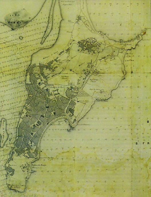
China / East Coast / MACAU / with / the Islands and Neighbouring Shores / Made by / Mr. W. A. READ C. E. / 19865-6 -- Detail.
*Revised reprint from:
CALADO, Maria - MENDES, Maria Clara -TOUSSAINT, Michel, MACAU: Memorial City on the Estuary of the River of Pearls, (Consortium <>, [c. n. n.], Government of Macau, August 1985.
Grateful thanks are due to the following Government Organisations, Services and Entities, who have contributed to the preparation of this document:
Governo de Macau (Government of Macao); Leal Senado(Municipal Council), Macao; Paço Episcopal de Macau; Comando das Forças de Segurança de Macau; Direcção dos Serviços de Obras Públicas e Transportes, Repartição de Edifícios da Direcção dos Serviços de Obras Públicas e Transportes, Macao; Direcção dos Serviços de Educação e Cultura, Macao; Repartição de Urbanismo de Direcção dos Serviços de Obras Públicas e Transportes, Macao; Direcção dos Serviços de Estatística e Censos, Macao; Direcção dos Serviços de Turismo, Macao; Direcção dos Serviços de Economia, Macao; Instituto Cultural de Macau (Cultural Institute of Macau); Comissão da Defesa do Património Urbanístico, Paisagístico e Cultural de Macau; Biblioteca Central de Macau (Central Library of Macao); Arquivo Histórico de Macau (Historical Archive of Macao); Museu Luís de Camões (Luís de Camões Museum), Macao; Imprensa Nacional de Macau; Serviços Hidrográficos da Marinha, Macao; Serviços de Cartografia e Cadastre de Macau; Repartição dos Serviços de Planeamento e Coordenação de Empreendimentos, Macao; Repartição do Turismo e Indústria Hoteleira, Macao; Companhiade Electricidade de Macau, Sociedade Anónima de Representações Limitada; Gabinete dos Assuntos Sociais, Lisboa (?); Biblioteca Nacional de Lisboa (Lisbon National Library); Arquivo Histórico Ultramarino (Overseas Historical Archives), Lisbon; Direcção dos Serviços e Fortificações de Obras do Exército, Lisbon; Museu, Biblioteca e Arquivo da Marinha; Arquivo Histórico Militar (Historical Archives of the Army), Lisbon; Biblioteca da Sociedade de Geografia de Lisboa (Library of the Geography Society of Lisbon), Lisbon; Museu Nacional de Arte Antiga (National Museum of Ancient Art), Lisbon; Delegação Portuguesa da UNESCO, Lisbon; Arquivo Nacional da Torre do Tombo (National Archive of the 'Torre do Tombo'), Lisbon; Biblioteca Nacional da Ajuda (National Library of the Royal Palace of Ajuda), Lisbon; Arquivo Histórico do Ministério das Obras Públicas (Historical Archives of the Ministry of Public Works), Lisbon; Instituto de Investigação Tropical (Institute of Tropical Research), Lisbon; The British Museum, London; University of Hong Kong -- School of Architecture; Hong Kong Museum of Art; Hong Kong Museum of History; Hong Kong University -- Main Library.