Since the Earliest Days of their mission there, the Jesuits in China took as a major goal the geographical delineation of the Empire. The cartographic materials they accumulated served to instruct and satisfy the curious among the Chinese about the relationships of the World's Continents. The missionary maps positioned China in its place in modern cartography and also answered the question of the Chinese: Where had these "wise men from the West" originated? Jesuit cartographers in China also published works for the instruction of Europeans interested in the East and were fully aware of the benefits that derived from the pictorial quality and visual accessibility of maps, all of which transcended language. The cartographic labours of the Jesuits also served a more direct missionary need of aiding the task of evangelization throughout the vast Empire of China.
From the first days of the China Jesuit mission until the suppression of the Society in the last part of the eighteenth century, mapping was seen as a cooperative project among the Jesuit Fathers and Brothers and their Chinese colleagues, Christian and non-Christian. The Jesuits produced cartographic works in the service of the Chinese imperial court for the furthering of the Catholic mission and for the unsated European scholarly appetite for information on China.
This tradition of Jesuit cartography of China is a story with a climax. The high point of the Jesuit mapping of China was the production of an atlas based upon actual surveying of the whole of the Chinese empire, a project sponsored by the Kangxi Emperor (r. 1661-†1722) in the first quarter of the eighteenth century. The results were published both in China and in Europe and provided both those worlds with the most accurate image of the Chinese Empire yet seen; this atlas served well until the mid-nineteenth century.
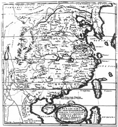 Paradigma XV Provinciarum et CLV Urbium Capitalium Sinensis
Imperii Cum Templis quae Cruce † Signantur et Domiciliis S. J.
In: COUPLET, Phillipe Tabula chronologica Monarchiæ Sinicæ, Paris, 1686.
Paradigma XV Provinciarum et CLV Urbium Capitalium Sinensis
Imperii Cum Templis quae Cruce † Signantur et Domiciliis S. J.
In: COUPLET, Phillipe Tabula chronologica Monarchiæ Sinicæ, Paris, 1686.
A strong tradition of geographical description and cartography in China had developed apart from and prior to the Western intrusion. Grand atlases and more specific provincial maps had been produced. The positioning of points on Chinese maps had not been done by astronomical observation but rather by measuring distances from point to point. However, by these means, surprisingly accurate maps were produced. 1 While there was a tradition in China, as in Europe, of religious cosmography, most Chinese cartography was created for administrative purposes. Recently, for instance, maps have been discovered dating from ca 150 BC. which seem to have had military and bureaucratic functions. The study of traditional mapping in China is now a topic of vibrant scholarship. A map of the Empire, depicting with some great accuray its eastern coast and its river courses, was carved on stone in AD 1137.
Chinese cartography reached its height in the Yuan Dynasty (1271-1368) when Chu Ssu-pen (ca 1273-1337) compiled his Yü ti t'u (Geographical Map), printed 1311-1312. This atlas does not survive in its original form, "but other maps produced at about the same time [...] make it clear that Chinese cartography during the Yüan completely overshadows anything that was being produced in the West at the same time."2 Lo Hung-hsien (° 1504-†1564), relying upon the work of Chu Ssu-pen as a primary source, produced a grand synthesis of all previous geographical work in his masterpice, the (Kuang-yü t'u) Comprehensive Map, composed ca 1540. This atlas was first printed in 1555-just twenty-eight years before the arrival of Matteo Ricci (°1552-†1610) into the Chinese Empire.
With the coming of the Jesuits, European geographical practices were introduced in China. Since the first days of the mission in the final quarter of the sixteenth century, the Jesuit scientist-missionaries had been interested in comprehending the geography of the lands in which they were laboring. They studied Chinese cartography, made their own maps of the regions, and interpreted European mapping knowledge for the interested and sceptical Chinese.
A major first step in the European process of mapping China was the map by the Portuguese cartographer, Luís Jorge de Barbuda (fl. 1580), published in the Theatrum Orbis Terrarum of Abraham Ortelius (°1527-t 1598), in 1584. Cited as "the first separate map of China to appear in Europe,"3 it answered the question for Europe: What does China look like? It also set the European stage for the Jesuit cartography of China, for in that same year, 1584, Ricci, who had arrived in China the year before, produced a Chinese version of a European map of the world, which he had brought with him. While no copy of Ricci's first Chinese map is known to exist4, we do know from his writings that he was familiar with an edition of Lo's Comprehensive Map and another Chinese map, the Ku-chin hsing sheng chih t'u (Map of the Configurations Ancient and Modern), which had been reprinted in 1555. 5 He also writes of possessing the works of Ortelius and Gérard Mercator (°1512-†1594). 6
Ricci continued to improve his World map. The extant version of his 1602 world map has become one of the most celebrated maps in the history of cartography. Ricci translated all terms and place names into Chinese, and positioned China toward the center of the map, thus giving the Chinese their traditional pride of place as chung kuo ("middle kingdom").
He produced this map to answer the questions put to him by the Chinese: Where do you come from? How do you describe the world? 8 [Ricci's World] map proved to be an important device for interesting the Chinese in his work, for its information and the various prefaces and descriptions on it served as a major propaganda tool. He himself tells us that many thousands of copies of his map were made, some under his supervision, while others were pirated. Indeed, his World map was quite influential in Asia decades after his death. Copies continued to be made, but often these versions were but travesties of the originals.
The Jesuits continued to produce World maps for the Chinese-translations and refinements of European maps combined with information derived from Chinese sources. Giulio Aleni, S. J. (°1582-†1649) produced in 1623 a geographical work, the Chih-fang wai-chi (Account of Countries Not listed in the Records Office)9. This is not only a map but also a geographical treatise describing the various parts of the world. Bernard Hung-kay Luk states that this geography may have been produced as "an inducement to the converted literati"10-knowledge in the service of the Faith.
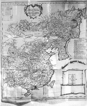 A Map of China Chinese Tartary And the Kingdom of Corea [...] By Mr D'Anville.
In: DU HALDE, Jean-Baptiste, S. J., A description of the empire of China and Chinese Tartary [...], 2 vols., London, Printed by T. Gardner for Edward Cave, 1738-1741, vol. 1, p. 1.
A Map of China Chinese Tartary And the Kingdom of Corea [...] By Mr D'Anville.
In: DU HALDE, Jean-Baptiste, S. J., A description of the empire of China and Chinese Tartary [...], 2 vols., London, Printed by T. Gardner for Edward Cave, 1738-1741, vol. 1, p. 1.
Refinements were also made of Ricci's map, such as a 1648 World map made by the Jesuit missionary Francesco Sambiasi (° 1582-†1649). A much simplified work, with fewer place names than on the Ricci map, the Sambiasi map does reflect some new knowledge gleaned since Ricci's map, for example, New Guinea correctly depicted as an island. In deference to the new Chinese dynasty, China is not named Ta Ming ("The Great Ming"), as on the Ricci map but is given a traditional name for China, physically denoting the Chinese (Chung hua) ("Middle Kingdom").
Ferdinand Verbiest, S. J. (° 1628-† 1707) produced an expanded edition of Aleni's geographical work to accompany a Chinese version of a contemporary European world map divided into two hemispheres. Verbiest's map, the K'un yü ch'üan t'u (Complete Map of the Terrestrial Globe), from 1674, took as its substantive source the 1661 map of Nicolaus à Wassenaer. 11 Verbiest switched the hemispheres in deference to the Chinese custom of having their country near the middle.
From the Ricci World map and its descendants and from the Aleni geography, the Chinese, the Japanese, and the Koreans derived much of their knowledge of the outside World. At the same time, traditional depictions of the World persisted.
In the seventeenth century, the emphasis of the China Jesuits switched gradually from the interpretation of Europe and the World for the Chinese to the geographical exploration and mapping of East Asia for the Europeans. The Far East had appeared on European maps since classical times, but only slowly did it begin to bear much resemblance to reality. 12
Not only did the Jesuits provide geographical information that was new to the Chinese but conversely they sent back fresh and more accurate depictions of China to Europe. In fact, it can be safely said that the geographic and cartographic image of China held by Europeans of the seventeenth and eighteenth centuries was drawn almost entirely from Jesuit information. The Jesuits, in turn, relied much upon the Chinese cartographic tradition. Most scholars have been too quick to ascribe single Chinese sources to many of the Jesuit maps of China. However, Kenneth Ch'en has identified some of the many sources drawn upon by Ricci. 13
The Chinese scholar Ma Yong argues that the long-held belief that the maps of Martino Martini, S. J. (°1614-†1661) were primary translations from the Comprehensive Map is too simple. He makes his point in a recent study of Martini's Novus Atlas Sinensis, the major Jesuit cartographic work on China in seventeenth-century Europe. 14 Martini relied upon many late Ming-Dynasty local gazetteers, critically comparing texts and drawing reasoned conclusions, and defined the Chinese Empire for Europe in a volume that included not only accurate Provincial maps but also detailed written descriptions of the various areas of China. He gave statistical, physical, economic, and political geographic information on each of the Provinces; and by means of cartographic symbols, he designated administrative centers, ore-bearing mines, Jesuit Residences, and geographical details such as mountains and lakes. He freely admitted that he had not created his geographical work single-handedly but had relied upon the work of Jesuit colleagues who had preceded him. He was also assisted by Chinese friends who led him to the best sources and some-times even made abstracts of longer Chinese materials. 15 Upon the publication of Martini's Atlas in Europe, in 1655, a fellow Jesuit missionary remarked: "Father Martini in his Atlas has made a Geographical Description of the Chinese Empire so complete and full, that there hardly remains anything more for us to desire."16
At the same time that Martini's Atlas was being compiled, another China Jesuit, the Polish-born Michel Boym (°1612-†1659), was creating an atlas that consisted of Provincial maps and of a description of China. While Martini was working with the newly established Qing Royal family (1644-1911), Boym arrived in Europe to represent the Ming pretender, the Yongle Emperor (Chu Yulang) (r.1623-†1662), in a vain hope of securing Western aid in reestablishing Ming Dynasty control of the Chinese Empire. While en route to Europe in 1651-1652, Boym worked on the maps and geography of China, but his atlas was never published, probably because of the appearance of Martini's work. Manuscripts of Boym's maps are scattered, some are lost. 17 One of his maps, however, was published, thanks to the French cartographer Nicolas Sanson d'Abbéville (° 1600-+|1667). 18 Because Martini and Boym were working on atlases of the Chinese Empire at the same time, Walter Fuch's question whether any relationship exists between the two works is quite relevant. 19
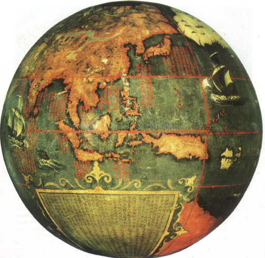 The Chinese globe, made in 1623, in China, by the Jesuit Frs. Manuel Diaz Junior and Nicolao Longobardi.
Nicolao Longobardi (°1559-†1654), from Sicily, arrived in China, in 1597. Manuel Diaz (°1574-†1659)was born in Castelo Branco and arrived in China, in 1611.
Matteo Ricci had already complained that he had been forced to convert curves into straight lines when he had his third version of the World map, made in Beijing, in 1602, since the best way to represent the Earth would be as a sphere. Ricci's map and this globe may be considered the two most important relics of the early cartography in China.
Courtesy of The British Library, London.
The Chinese globe, made in 1623, in China, by the Jesuit Frs. Manuel Diaz Junior and Nicolao Longobardi.
Nicolao Longobardi (°1559-†1654), from Sicily, arrived in China, in 1597. Manuel Diaz (°1574-†1659)was born in Castelo Branco and arrived in China, in 1611.
Matteo Ricci had already complained that he had been forced to convert curves into straight lines when he had his third version of the World map, made in Beijing, in 1602, since the best way to represent the Earth would be as a sphere. Ricci's map and this globe may be considered the two most important relics of the early cartography in China.
Courtesy of The British Library, London.
Philippe Couplet, S. J. (°1624-†1693) provided a map to accompany his Tabula Chronologica Monarchiæ Sinicæ. Like Martini and Boym before him, he returned to Europe on a propaganda tour and like them, took with him a young Chinese Christian. The map in Couplet's Tabula is drawn after Martini's, and while Couplet had freely taken information from another of his Jesuit confreres, he still kept to the Ming division of China into fifteen Provinces, years after the creation of three more Provinces in the Qing. 20 This reliance of one Jesuit upon the work of his predecessors in China was, as Boleslaw Szczesniak points out, very common. 21 many of the scholarly projects carried out by the China missionaries can be seen as ongoing refinements of earlier efforts transcending the work of any one man and all "To the Greater Glory of God."
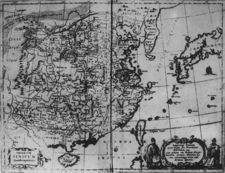 Imperium Sinicum in XV Regnis Gen. Provincias [...].
In: KIRCHER, Athanasius, S. J.; Trans. DALQUIÉ, F. S., La Chine d' Athanase Kirchere[...], Amstelodami, Johannem Jenssenium à Waesberge [..,],1670, pp. 4-5.
Imperium Sinicum in XV Regnis Gen. Provincias [...].
In: KIRCHER, Athanasius, S. J.; Trans. DALQUIÉ, F. S., La Chine d' Athanase Kirchere[...], Amstelodami, Johannem Jenssenium à Waesberge [..,],1670, pp. 4-5.
Martini and his confrères had been encour aged to make a consistent effort to fix positions around their mission stations whenever they could. Martini himself took many readings to determine the accuracy of his maps. However, it was not until the arrival of the first official French Jesuit mission in China in 1687 that a conscientious effort was made to create a cartography of the Empire based upon Western methods of survey. 22
From the outset of the French mission to China, geography was envisioned as playing a large role, reflecting the significant French interest in Chinese geography. Of the first French contingent of Jesuits, several were chosen because, among other reasons, of their geographical training. During the voyage East, they divided their scholarly pursuits, since upon their arrival in China, each man was to specialize, and a new and more organized corporate scientific effort was to be inaugurated.
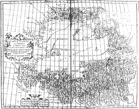 Carte generale du Thibet ou Bout-tan et des Pays de Kashgar et Hami [...].
In: D'ANVILLE, Jean-Baptiste, Nouvel Atlas de la Chine, the Hague, 1747.
Carte generale du Thibet ou Bout-tan et des Pays de Kashgar et Hami [...].
In: D'ANVILLE, Jean-Baptiste, Nouvel Atlas de la Chine, the Hague, 1747.
In Europe, Paris had become the center of cartographic progress in the late seventeenth century. In 1669, the Italian-born astronomer and topographer Jean-Dominique Cassini (° 1625-†1712) was summoned to Paris to direct the Observatory there. In 1679, he constructed a great planisphere which was to be corrected constantly as new discoveries, measurements, and observations were made. 23 It was his plan to remap the World. Louis XIV's minister, Jean-Baptiste Colbert, raised money for scientific activity. Louis XIV himself visited the Paris Observatory on the 1st of May 1982, and was quite impressed with the progress being made in cartography and with the precision of the geographical discoveries. Little wonder then that when Couplet arrived in Paris the same year fresh from the Chinese mission, the request he carried from the Emperor of China for French Jesuits was welcome and timely.
Scholars from all over the World contributed data to assist Cassini in his mapping efforts. Among them was Jean de Fontaney, S. J. (°1643-†1710), professor of mathematics at the Collège Louis-le-Grand. While preparing to head the first French Jesuit mission to China, he conferred with Cassini about the possibility of obtaining astronomical data for the Paris Observatory and of making geographical observations. Before he left Paris in 1685, Fontaney had been trained in geographical technique and had promised to contribute data on Asia. 24
A further connection exists between France, the missionaries, and the geographical description of China. The study of geography in France during the seventeenth and the first half of the eighteenth centuries is tied intimately to Jesuit education. 25 Geography was taught within the framework of the curriculum of rhetoric and belles-lettres. History, literature, chronology, and geography all were in the realm of the liberal arts. Jesuits such as Philippe Labbé (°1607-†1667) and Philippe Briét (°1601-†1668) taught geography as part of the curriculum at Collége Louis-le-Grand in Paris, where all the missionary envoys sent by Louis XIV to China, in 1685, had studied. 26 Instruction was taken from manuals and geographical dictionaries. 27
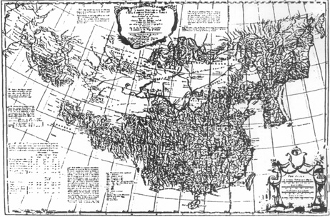 A General map comprising China, Chinese - Tartary & Tibet [...], by Jean-Baptiste d'Anville.
In: DU HALDE, Jean-Baptiste, S. J., A description of China, London, 1738-1741.
A General map comprising China, Chinese - Tartary & Tibet [...], by Jean-Baptiste d'Anville.
In: DU HALDE, Jean-Baptiste, S. J., A description of China, London, 1738-1741.
Many of the prominent cartographers of the day were products of Jesuit education. How they came to be trained scientists, despite the unbending and superficial course of geography outlined above, can be explained only if the double function of the Jesuit College is understood. The Colleges existed as training places for the pious élite of France; the years of rhetoric and belles-lettres were designed to give a Cultural 'finish' to the laity. However, they were also centers of Jesuit learning and inquiry, institutions for higher learning and research of the Jesuit scholar-philosophers. It is within this latter function, lying beyond the manuals and pedagogy of high school geography, that we must look to find the training ground for the scientific methods and activities of France's gifted map makers.
Cartography in the late seventeenth and early eighteenth centuries was a family enterprise dominated by two French clans, the Sansons and the Delisles, both educated by the Jesuits. In addition to formal schooling, father taught son and nephew, and maps flowed for over a century from these two families. Like the Sansons, Guillaume Delisle (° 1675-†1726) along with his father Claude (° 1644-†1720) and brother Joseph-Nicolas (°1688-†1768) analyzed great amounts of material gleaned from reported voyages, observations, and surveys. 28 Geography and astronomical observations were given a prominent place in the journals of the day, such as the Journal de Trévoux29 and Mémoires de l'Académie des Inscriptions et Belles-Lettres. The reports of voyages of circumnavigation, nautical records, and astronomical findings sent from the missionaries to their correspondents and confreres in Europe all proved to the scientific cartographers of the day the inaccuracy of former maps and demonstrated the need for cartographic reform.
A bond of union, strengthened by a common membership in learned societies, grew up between the cartographers of Europe and the Jesuit missionaries so deeply involved in geographical inquiry. Jean-Baptiste Riccioli, S. J., (°1598-†1671) worked out longitude and latitude bearings from mission posts outside Europe; and by the turn of the eighteenth century, the missionaries had fixed the positions of most of China's major Cities. Unfortunately, measurements for the longitude and the circumference of the Earth were not yet accurate. 30 It was not until modern geographical methods were employed by Guillaume Delisle that China would be placed more or less correctly. He abandoned the Ptolemaic measures used in Nicolas Sanson's classic maps of Asia (Sanson's map of 1669 has the longitude of China too far to the East by some twenty degrees) in favor of the direct observational calculations of the missionary Martini in his Atlas.31 Delisle's World map of 1700 puts the Far East in proper position for the new calculations of the circumference of the Earth. In addition to his use of the Jesuit China missionary material, Delisle had availed himself of Russian accounts of Muscovy's Eastern regions. 32 His was a map of contemporary sources. This, then, is the background from which the Jesuit cartographers in China emerged and the milieu out of which the European cartographic editor of the grand Jesuit survey of the Chinese Empire of 1708-1718 would emerge.
After the arrival of the French Jesuits in China, in 1687, there was much activity on their part: proselytizing for the Christian faith, strengthening the Jesuit position in the Kangxi Court, pursuing the scientific and Cultural studies they had planned. One of the greatest projects the Jesuits undertook was the overseeing of the Imperial survey of the Chinese Empire. By the first decade of the eighteenth century, a genuine need for an accurate geographical representation of China was quite apparent to the Kangxi Emperor because of the rapidly expanding Qing Empire. The Jesuits had proved their interest and had given ample evidence of their expertise and capabilities in survey and map making. Support from the Emperor, combined with a sufficient number of Jesuits trained in cartographic technique and with enough background information on the areas to be covered, allowed the Fathers to contemplate the production of a complete, scientifically produced atlas based on a survey of the Empire. The work on this project fulfilled the Jesuit's desire to map China and provided them with an opportunity once again to prove their worth at the Imperial Court. The resulting atlas was the first truly accurate portrayal of the whole expanded Chinese Empire on either a Chinese or a European map. The maps produced by this scientific expedition and study not only provided the Chinese Imperial Government with an atlas, but they were also sent to Europe and became a European atlas of China as well.
According to Joseph Needham, 33 it was Jean-François Gerbillon, S. J. (°1654-†1707) who gave the Kangxi Emperor the idea of producing an imperially sponsored atlas of the expanded Chinese Empire, using the Jesuit missionary talents of survey and cartographic technique. However, Antoine Gaubil, S. J. (°1689-†1759) credits his confrere Dominique Parrenin, S. J. (°1665-†1741) with encouraging the Emperor. He writes: "It is Father Parrenin who found the means by which to nurture in the Kangxi Emperor a desire to see a map of the Great Wall."34 This map of the Great Wall was one of the first produced by the surveyors; Gerbillon then further encouraged the Emperor to continue the project. 35 The Great Wall map and smaller surveys were, in part, the impetus for (and became part of) the grand project; in addition, inspiration for the project came from the close contact between the emperor and his Jesuit companions at Court.
The periodic flooding of the Pei River and the Wen yu River, for instance, convinced the Kangxi Emperor of the need for a detailed survey of the environs of the capital City of Beijing. In 1700, the Jesuits Antoine Thomas (°1644-†1709), Joachim Bouvet (° 1656-† 1730), Jean-Baptiste Régis (° 1663-†1738), and Parrenin were called upon to map the region. 36 As Jean-Baptiste Du Halde, S. J. (°1674-†1743) says in his Description [...] de la Chine [...]: "This grand prince had given the command to the missionaries to make up a map of the environs of Beijing, in order to judge for himself how many of the European methods were exact."37 Within seventy days, the map was complete and in the hands of the Emperor.
The Monarch, quite satisfied with the map, called upon Bouvet, Régis, and Pierre Jartoux, S. J. (°1669-†1720) to map the area surrounding the Northern Great Wall from Yung-p'ing to Hsi-ning Kansu. 38 This ancient barrier to alien invasion from the North had been expanded, strengthened, and repaired under the previous Ming Dynasty. That the Wall had deterred the Manchu Tartars from overthrowing the exhausted Ming and that it stood as a symbol of Chinese resistance to Northern barbarians may have inspired the Kangxi Emperor's interest in the Wall's situation.
In any case, Régis, a trained geographer, took charge of the project and set out on the 4th of June 1708 (KX 16:4:47)with his small band of Jesuit surveryors. Joseph Marie-Anne de Moyriac de Mailla, S. J. (° 1669-†1748), though not involved personally in this project, left a chronicle of the trip, 39 supplementing the accounts given by Régis and Gaubil. The three Jesuits, Bouvet, Régis and Jartoux journeyed to Shan-hai-kuan, the pass at which the Great Wall meets the sea, 40 and followed the Wall to near Suchou, then continued on to the Northern extremity of Shenhsi Province. From there they descended to Hsinan and returned to Beijing, on the 10th of January 1709. 41 Although Bouvet had fallen ill after two months of working on the project, Jartoux and Régis continued the work, plotting exact positions, and returned with a map some fifteen feet in length. Very detailed it included rivers and forts and some three hundred gate entrances in the Wall as well as each gorge and hill upon which the Wall wound its route. 42
The Emperor was well pleased with the resulting map, and with the exemplary surveys of the environs of Beijing and the Great Wall in hand, judged the projects a success and saw the value in having the Jesuits map the entire empire. Such mapping was viewed as a necessary contribution to the successful policing of scattered local Governments, to the maintenance of Imperial control, and, above all, to the understanding of the geographical situation and extent of the Empire.
Charged by Imperial request to provide an accurate and specific atlas of the Chinese Empire, the Jesuits set out to survey all of the Chinese Provinces and to gather information on the outlying regions of Tibet, Tartary and Korea. Within a decade, this immense work was finished, and a remarkable precise masterpiece could thus be presented to a satisfied Kangxi Emperor.
By the 8th of May 1709, 43 Jartoux and Régis, together with the Austrian Jesuit Ehrenberg Xaver Fridelli (° 1673-†1743), began the difficult project of mapping Eastern Tartary; the homeland of the Manchu-Mukden, Jehol, the Wu-su-li Chiang (Ussuri River), and the mouth of the Hei-lung Chiang (Amur River). 44 As Du Halde wrote:
"This was a difficult task, because that country having been as it were abandoned for many Years, it seem'd scarce possible to find the necessary supplies of men, horses and provisions, for a work that was to continue for several months. But as nothing escaped the Emperor's foresight, he gave so good orders to the Manchew Mandarins who govern the cities, whereon those uninhabited countries depend, and those orders were so punctually executed, that the work was never retarded."45
To undertake such a vast project as mapping the Empire required the Emperor's sponsorship, and one sees here the importance of Imperial aid in facilitating the arduous work.
As a starting place, the Jesuits were able to use the earlier survey of the Great Wall as the Southern boundary of their new project. The map of Eastern Tartary was finished by the end of the year. Like the earlier maps, this one was well received, again with a personal sense of satisfaction on the part of the Manchu Emperor:
"This Work was very agreeable to the Emperor, as well as to the Manchews born at Beijing, who there beheld their ancient country, and were able to learn more from it in a quarter of an Hour than by discoursing with ever so many travellers."46
The three Fathers were then ordered to proceed to the mapping of the Peichihli, or the Imperial Province wherein lies the capital of Beijing, and worked there from the 10th of December 1709 to the 29th of June 1710. This map was significant because of the area's importance as the seat of Government of the Empire:
"This map was the more acceptable, as the Province it described was well known. The Emperor took the pains to examine it himself, and seeing the places justly exhibited which he had often passed through, and caused to be measured by the Manchews, (whose business it is to survey the roads when he goes into the country) he signify'd to the Missionaries that he would answer for the Accuracy of it; and that if the rest proved as good, their performance would satisfy him, and be out of the reach of criticism."47
Thus it appears that until this time the Jesuit cartographers were still on trial. There were those in the Chinese intellectual community who were opposed to the European influence in map making, men who had positions that were threatened by the Jesuit scientific and cartographic intrusion. The Kangxi Emperor in ordering a mapping of the capital Province, an area well documented, could study the new maps and see their superiority.
With the success of the map of Peichihli, the missionaries, Régis, Jartoux, and Fridelli, were sent to the middle course of the Amur River, 48 to the area of the Seh-leng-eh [Chiang] (Selenga River), 49 and North of Ulanbaator, in Mongolia. They worked on the survey of those plans from the 22nd of July 1710 to the 14th December of the same year. Regarding this map, "tho' it was empty enough, [...] the Emperor was pleased with it"50 as he was desirous to see the position of the Cities he had founded for the purpose of establishing strategic bases in this vast area of nomadic Mongol tribes. 51 The area around the Amur River had also acquired importance with the conclusion of the Treaty of Nerchinsk between Czar Peter the Great (° 1672-† 1725) and the Kangxi Emperor, in 1689. Vast areas of sparsely settled land had been in dispute; the Manchu side had won a diplomatic victory and wished to keep its winnings. 52
By 1711, with the Emperor now strongly behind the Jesuit mapping project, it became apparent that in order for the survey to be completed speedily, the Jesuits should divide into several surveying groups. Thus, the mapping of the Provinces of China proper as well as remaining outlying areas would be completed by groups working simultaneously. 53 Régis, together with a Portuguese Jesuit mathematician, 54 João Cardoso (°1671-†1723), went to Beijing's neighboring Province of Shantung. Jartoux, Fridelli, and Guillaume Fabre-Bonjour (°1669-†1714), an Augustinian friar, 55 mapped the Ordos, and then the upper course of the Amur and Selenga Rivers and the region around Hami (Kumul, in the present-day Uighur Autono mous Region). 56 The year 1711 drew to a close, and the Emperor asked if more Jesuits could not be found who were skilled in geography and pressed into service. Three were recruited: the aforementioned de Mailla, Pierre-Vincent de Tartre (°1669-†1724), and Romain Hindered (°1669-†1744). All were accepted by the Kangxi Emperor. After this, three separate groups worked to complete the project of surveying the Provinces. 57
In 1712 and early in 1713, maps of Shanhsi and Shenhsi were completed by de Tartre and Cardoso. These maps are described by Du Halde as being "each ten feet square."58
"The Mandarin who presented these maps to the Emperor, having informed his Majesty, that if he required any thing to be explain'd, Pére de Tartre was in waiting to obey his commands, the Emperor sent for him, to point out some Places he had himself observ'd in these Provinces: which done, that Prince said several times I-tyen-pu-tso [ I tien pu tso ], "He is right in everything."
There happened one thing pretty remarkable in this audience: The Emperor alledged that the course of a River was wrong in another map, which had relation to the maps of Shan-si and Shen-si: Pére De Tartre, sensible to his Majesty's mistake, maintained the truth (with all due respect,) in so clear a Manner, that the Monarch came into his opinion; Tso lyau [ Tso liao ], says he, "I am mistaken." A great concession in an Emperor of China!"59
By the end of 1715, the remaining eleven Provinces had been mapped: 60 Chianghsi, Kuangtung, and Kuanghsi (1713-1714, by de Tartre and Cardoso); Honan (1713, by Régis, de Mailla and Hinderer); Chiangnan (1713-1714, by Régis, de Mailla and Hinderer); Chechiang and Fuchien (1714, by Régis, de Mailla and Hinderer); Ssuchuan (ca 1713-1714, by Fabre-Bonjour and Fridelli); Yünnan (ca 1714-15, by Fabre-Bonjour [died during the survey, in 1714], 61 Régis and Fridelli); Hukuang and Kueichou (1715, by Régis and Fridelli). In January 1717, Régis, who had directed the survey, returned with Fridelli to Beijing. There, under the direction of Jartoux, who had been forced to stay in Beijng because of illness, they worked on the compilation of a general map of all the Provinces; it was presented to the Emperor, in 1718.
The methods and devices used by the Jesuit cartographers in their China survey are recorded in several documents. Antoine Gaubil wrote of the cartographic techniques in a letter from Beijing (?), in 1728, to Étienne Souciet, S. J. (°1671-†1744), a correspondent in Paris:
"These Fathers requested a quadrant of two inches in radius; they often checked it carefully and they constantly found that it constantly represented the altitudes as too great. They had a great compass, several instruments, a pendulum and other things needed for the fulfilment of the Emperor's orders. With cords divided exactly; they accurately measured the way from Beijing. On this road, they often took observations of the meridian of the sun. At every moment they observed the rhumb and took great care in observing the variation and declination of the peak.
In all these vast regions, the Fathers Régis, Jartoux, Fridelli, [Dominique] Parrenin, have observed the height of the Pole, measured the distances, observed the rhumb lines, and familiarized themselves in detail with the country of which Father Verbiest had already made his acquaintance."62
Earlier, Bouvet in his Voiage de Siam [...] outlined the scientific preparations and described the instruments the French Jesuits took from Paris to Beijing. 63 Régis in his manuscript work, Nouvelle géographie de la Chine et de la Tartarie orientale, also included a detailed outline of the methods used in collecting the data. 64 He praised the method of triangulation and pointed to the care with which the Jesuits proceeded, namely, their observing longitude for verification, noting eclipses, and carefully making measurements for all areas. He stated that the present work of the Jesuit cartographers in China was even more accurate than contemporary maps of Europe and singled out defects in Ptolemy's geographical system and the uncertainty of ancient measures. Finally, he observed that inequality in degrees of latitude were discovered and that longi tudinal recording could not be taken by variation of the compass.
Other sources mention the procedures, but none documents them so well as Régis. Basically, points were plotted by triangulation, the resulting work being the first major atlas derived from measurements obtained by this method. 65 John F. Baddeley estimates that the Jesuits took a total of 641 points of both longitude and latitude fixed by astronomical or geographical measurements and reminds us that they collected whatever material could be obtained in the provincial administrative institutions. 66 The twentieth century historian of the mission, Henri Bérnard-Maître, S. J., describes the method succinctly:
"As one can see, the fundamental method that the cartographers used consisted of measuring distances to obtain the latitude and the longitude of different places. As for the latitude, this process was completed and verified by means of the observations of the sun's meridian and of the polar stars. As for the longitude, the missionaries were sometimes aided by eclipses of the moon and of the satellites of Jupiter, but were often prevented from carrying out their method with the precision desired."67
The missionaries took their longitudinal readings with Beijing as meridian. They knew that their instruments were imperfect and imprecise and that to measure with Paris as a meridian would have caused even greater distortion and imposed the inaccuracy of the distance from Paris to Beijing on the whole of the work. 68 By the late nineteenth century, cartographic historians, such as Julius von Klaproth and Edouard Biot, were aware that as the readings of the Jesuit survey were taken from locations farther and farther away from the Beijing meridian, errors likewise became greater and greater; 69 this of course was due to the imperfection of instruments then available. Du Halde, in his author's preface, explains why the Beijing meridian was used: "It is from the meridian of Beijing that the longitudes are counted (and this is not exhibited at all) to fall in some error, that they did not want to reduce them on the meridian of Paris."70 A number of critics of Du Halde's work objected to this orientation, among them Edward Cave, the cartographic editor of the Description of China. 71
As Baddeley hinted, the Jesuits did not fail to rely upon native materials regarding the geographical description of the Empire. Although they were at times hampered by Chinese and Manchu jealousies because of difference in method and the potential for loss of reputation and position, 72 they prevailed, thanks to Imperial sponsorship. However, without the help of native functionaries trained in Western cartographic method as well as the use of Chinese explorations and the traditional Chinese cartography, the Jesuits could not have completed their survey. They collected and studied indigenous works and gathered information from local officials as they traveled. This Chinese material was, wherever possible, checked against the Jesuits' own observation in the field.
In his preface, Du Halde paraphrases Régis and plays down the importance of the work of non-Jesuits:
"The case is otherwise [than those earlier geographical works which appeared in Europe based on Ptolemaic systems and Chinese sources] in the Work we offer the Publick; for vast as it is, we judged we ought not to confine ourselves either to the Maps of the Chinese Governers, or to the Distances measured almost throughout the whole Empire, and particularly in Tartary, with great Labour and Exactness, by the Manchews; nor yet to the printed Memoirs, whereof we had divers: But we resolved to begin the whole anew, employing those Materials no farther than as Guides, in the Roads we were to take, and in the Choice of Places for Observation; it being our Intention to reduce all that we had, to the same Measure, as well as design."73
In fact, the Jesuits relied more heavily on native help than on their own decision as to which "Roads [they] were to take."74 Their dependence on Chinese work for the maps of Tibet was almost total. They used Chinese assistants and Manchu material extensively in other maps. Earlier in his preface, Du Halde himself had outlined the emperor's insistence that several mandarins take charge of making measurements for the Jesuit survey.
"[The Kang-hsi emperor] commanded to great Tribunals to nominate Mandarins to superintend the Measurements, to the end that they might give the exact Names of the most remarkable Places they were to pass thro; and cause the Magistrates of Towns to attend on the Bounds of their respective Districts with their People, and afford such other Assistance as shou'd be deem'd requisite. All this was performed with surprizing Punctuality; which is a manifest Proof of the admirable Order and Policy observ'd thro' that vast Empire."75
Many other functions were performed for the Jesuits by the Chinese and Manchu under order of the emperor.
Du Halde, although inaccurate in his acknowledgment, does allude to the debt of the Jesuits to the continued Chinese awareness of the importance of geography and cartography. As Needham, perhaps in a typical sinophilic overstatement, writes:
"It was owing to the solid work of generations of Chinese mapmakers that knowledge of this part of the world became incorporated in modem geography."76 That the Jesuits could produce an atlas of the vast Chinese Qing Empire in one decade was due as much to the tradition of Chinese cartography, upon which they could draw, as it was to the cartographic expertise of the Jesuit scientists. The imperial backing of the interested Kangxi Emperor was, of course, of enormous importance also."
Certainly one of the most obvious parts played by the Chinese was in the gathering of material for the making of the maps of Tibet; for, although the maps of that region were contained in the Jesuit atlas, Tibet was not part of the Jesuit cartographic survey project. In order to produce maps of this region, as well as of a few other inaccessible areas (Japan, Korea, and the extremities of Manchuria, for instance), the Jesuits used local information provided by Chinese and Manchu officials. 77 For example, the Kangxi Emperor had ordered Ho-shou († 1715), a Manchu official and his newly appointed imperial representative to Lhasa, to have a map of Tibet drawn up. 78 Du Halde records: "During the two years that this Ambassador continued in Tibet, he employed some of his Attendants, who he had carry'd with him for that Purpose, in making a Map of all the Territories immediately subject to the Great Lama,"79 In 1711, upon Ho-shou's return to Beijing, his cartographic sketches were given to Régis. These became the basis for the four maps of Tibet in an early version in twenty-eight sheets of the Chinese edition of the Jesuit atlas of China. 80 Thus, Ho-shou has been called the founder of modern cartography in Tibet. 81 One must remember that the Chinese had explored the mountain areas of Tibet long before the Europeans ever arrived. 82
The maps of Tibet given to Régis in 1711 were not totally satisfactory, and at intervals over a two-year period (1715-1717), he so informed the Emperor. As a result, since the conflict in Tibet had been subdued and a puppet of the Qing installed as Dalai Lama, another Imperial geographical survey group was sent out. It included three imperial envoys and two Lamas whom the Jesuits had instructed in Western science. This scientific mission, which seems to have had no Diplomatic purpose, was under the command of the Secretary of the Mongolian Superintendency, Seng-chu (Sengju). The mission had orders to procure more detailed geographical information on Tibet, the determination of coordinates, and the measurement of the altitude of the chief mountains. 83
This cartographic material was employed to draw new maps of Tibet for the second woodblock edition of the Jesuit atlas (in thirty-two sheets) published in China, in 1721. 84 The information was also used in the first draft of the description of Tibet in the Chinese work Ta Ch'ing i t' ung chih (General Geography of the Ch'ing Empire).
The cartographic material for Korea also was derived from Chinese sources, as the Jesuits were not able to make survey expeditions into that Kingdom. Régis, who once again was responsible in major part for the compilation of the Korean map, analyzed the Chinese findings, comparing them with Korean border sightings made by his Jesuit colleagues. In this way, he was able to judge, although somewhat unsuccessfully, the accuracy of the material provided him.
In addition to their reliance on Chinese materials for places inaccessible to them, the Fathers availed themselves of Chinese and Manchu scholars, helpmates, and assistants who labored with them on the survey project. Among them was Ho Kuo-tung (18th C.). 85 Régis, Hinderer, and de Mailla were also aided by Chinese co-workers in the mapping of Formosa [Taiwan]. 86
The great geographical and cartographic activity that took place in the Kangxi period certainly aided the Jesuits in their work. The personal interest of the Emperor and his knowledge of the vastness of his dominions acted as a catalyst not only to the Jesuit survey but also to the expeditions of Chinese, Manchu, and Mongol explorers. 87 To know the extent of the Empire, to aid in communication, and to stem revolt were of paramount importance to the effective control of this vast territory.
One might well ask who was tending the Chinese Christian flock while these Jesuit scientists were so deeply engaged in their geographical work. In 1717, about one-hundred-and-twenty Jesuits were at work in China; of these, twenty-eight belonged to the French mission. 88 Louis Pfister, in his biographies of the China Jesuits, is quick to remark that, even when on scientific expeditions, they never missed a chance to preach the Gospel in the hinterlands they passed through on survey; for example, he says of Fridelli that "in his long voyages from the North to the middle of the Empire [Fridelli] was still more apostolic than geometric [scientific] and [he] never missed the occasion to announce the Gospel and to preach to the pagans."89 Hinderer, Régis, and de Mailla also made it clear that they availed themselves of the opportunity for extensive travel to proselytize where the Christian message had yet to be heard. 90 The present day Jesuit historian of the missions, Joseph Dehergne, gives the figure of three-hundred-thousand Catholic Chinese, in 1700. 91
The maps prepared by the Jesuits for the Kangxi Emperor were presented in Beijing as a completed survey, and plans were made to print a Chinese edition. Four different editions appeared during the period 1717-1726. The first, that of 1717, was a xylographic printing of twenty-eight maps. Entitled a Huang yü ch' uan lan t' u (Comprehensive Imperial Geographical Atlas) this edition, although important to the history of cartography because it was the first printing of the assembled data, was soon superseded by corrected and revised editions. In 1719, a manuscript version including thirty-two maps was drawn up, the additional three maps being of the Tibetan and upper Yellow River regions. The nomenclature had been standardized, and no Manchu words appeared on the maps. This copy, in turn, was divided into forty-four plates engraved on copper by the secular priest in Beijing, Matteo Ripa (° 1682-†1745), who had participated in the Jesuit survey and would later found the Collegio de' Cinesi della Santa Famiglia di Napoli, upon his return to Europe. A skilled engraver, he had earlier done a set of thirty-six copper plates-views of the Imperial Villa, at Jehol. 92 He had begun his work on the plates for the maps in 1718, 93 and produced an atlas of forty-four plates entitled Yü chin ta Ch'ing i t'ung chüan t'u (Modern Complete Geographical Atlas of the Great Ch'ing Empire)94 on a scale of 1:1,400,000. 95 The Qianlong Emperor (r. 1736-† 1796) in his poetic introduction to the Jesuit atlas produced for him in the 1750s spoke of this edition of the Kangxi atlas, "Engrave copper plates in order to print [that the atlas might be] handed down for all eternally."96 The copper plate edition was sent to Louis XV, of France, in appreciation for his support of the mission97 and copies are preserved in the topographical collection of George II, of England, 98 and in the Istituto Universitario Orientale di Napoli (successor to Ripa's Collegio de' Cinesi.). 99
In 1721, a second xylographic edition was printed in thirty-two plates identical in format to the manuscript version of 1719 upon which Ripa had relied, the only emendations to this edition being that many details on the maps of Tibet and the upper Yellow River were further corrected and the Manchu nomenclature was standardized to Chinese. 100 This definitive revised woodblock edition was sent by the Jesuits to Europe and would provide Du Halde with the material for the projected maps to be added to his Description de la Chine. The scale of this Chinese woodblock version and that of the separate provincial maps and the detailed maps of Tibet and Tartary in Du Halde's work is identical: 1:2,000,000. 101 This allows one to compare the European version with its Chinese original by merely placing one on top of the other. The historian of cartography Marcel Destombes, who has traced the very copy of the 1721 xylograph which was used to draw the maps of the Description de la Chine, states that it was housed in the Archives des Affaires Étrangères, in Paris, until 1943102 when it was taken to Germany, where it has yet to surface. 103 Henri Cordier reported on this copy before it disappeared:
"The original maps of the fathers in the Society of Jesus are registered today at the Archives of Foreign Affairs. They were bought from d'Anville by Mr Vergennes, in exchange for a lifetime annuity of 3000 francs. These maps form a Great Atlas (No. 1648); they are on paper from China, mounted on stronger paper and surrounded by a border of blue Chinese silk. The names of the cities are marked in Chinese characters."104
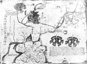
Map of Hainan and Guangzhou, by Michel Boym.
In: CHABRIÉ, Robert, Michael Boym, jésuite polonais et de la fin des Ming en Chine (1646-1662) [...], Paris, Pierre Bossuet, 1933.
In 1726, individual dissected sheets of China proper and of Manchuria, but none of Tibet or Mongolia, were included without coordinates in the great Qing Encyclopedic Collection, the Ku chin t' u shu chi cheng (Synthesis of Books and Illustrations of Ancient and Modern Times). 105 In addition, there have been re-editions of the woodblock edition of 1721. In 1832, a map to the same scale as the edition of 1721 was reprinted, the only difference being that this new edition was done in a long strip rather than as separate maps. It is entitled Huang Ch'ao i t'ung yü ti ch'uan t'u (Comprehensive Geographical Atlas of the Present [Qing] Dynasty) and was in turn reprinted as late as 1894. 106
Later in the eighteenth century, the Qianlong Emperor authorized a second Jesuit survey. The Portuguese Jesuits Félix da Rocha (°1713-†1781) and João de Espinha (°1722-†1788) were sent out to survey and make maps of Sungaria, Turkestan, and the land of the Eleuths, territories that had been recently annexed to the Chinese Empire. Working from 1756 to 1759 on the project, 107 they turned over their information and maps of these outlying regions to the Emperor. In 1769, Michel Benoist, S. J. (°1715-†1774), who had recently completed a world map in Chinese for the Qianlong Emperor, was ordered by that Monarch to draw up a new map of the Empire; it was to include the unpublished data, on the lands surrounding the Empire, that had been provided by the Rocha-Espinha expedition of 1756-1759. Within the same year (1769) and assisted by others, Benoist produced a xylographic edition and despite his protests that he was not adept at the art of copper engraving, he brought out a copperprinted edition of the same map in 1775. 108 His maps drew heavily on the Kangxi/Jesuit survey endeavours of 1708-1718 but different principally from those maps by their inclusion for the first time of the new cartographic data that had been gathered by the Rocha-Espinha expedition on Sungaria, Turkestan, and the land of the Eleuths. Benoist's maps, however, was not so influential as that of the earlier Jesuits in China, for it lacked a European editor who could interpret the data for the West.
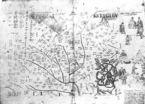
Map of Ghizou, by Michel Boym.
In: CHABRIÉ, Robert, Michael Boym, jésuite polonais et de la fin des Ming en Chine (1646-1662) [...], Pads, Pierre Bossuet, 1933.
From the correspondence of Antoine Gaubil, we find that Jean-Baptiste Régis sent a copy (copies?) of the Kangxi/Jesuit Modern Complete Geographical Atlas [...], in the woodblock edition of 1721, to France, 109 whereupon the Jesuit map was offered in 1725 to the King of France, by Du Halde had this atlas in Paris".110 Du Halde, in turn, employed a rising star of cartography in France, Jean-Baptiste Bourgignon d'Anville (° 1697-†1782), as cartographic editor of a European version of the China Jesuit Atlas and the maps he created for Du Halde's Description de la Chine were truly impressive.
The excellent maps in Du Halde's Description de la Chine were the result of a complex set of fortuitous circumstances. As noted earlier, many of the French Jesuits who went to China in the late seventeenth century were skilled in mathematics and geography, and of special importance was their knowledge of trigonometric survey. Their arrival coincided with the rapid expansion of Qing control, which occasioned Imperial authorities to give thought to the drawing up of a comprehensive atlas of a greatly expanded Empire. The Jesuits, building on their corporate tradition of cartography in China, demonstrated their scientific expertise and received willing Imperial sponsorship for this mammoth cartographic project.
The Jesuits' motives for pursuing such a project were many. Certainly scientific inquiry was an important factor. The drawing of earlier maps of China, those of Martini, for instance, had not employed triangulation methods of survey and often had been grounded only in the tradition of Chinese cartography rather than in new expeditionary research. Martini's maps also reflected the smaller empire of the Ming Dynasty. The compilation of new maps using up-to-date methods was needed; and the French Jesuits seized the opportunity to demonstrate to the Chinese, and to the Kangxi Emperor in particular, that the knowledge and methods brought from Europe could prove useful.
The ten-year survey of 1708-1718 also provided an opportunity for the Jesuits to travel widely on official business as recognized representatives of the Court. Not only did the missionary scientists ingratiate themselves with the Emperor by working on this important project, but they were also able to break new ground in their apostolic work. When visiting out-of-the-way places, when working with native talent on the survey, or when meeting with local officials, they never forgot that their primary charge was to spread the Christian message.
During this ten-year map making project, the Jesuits found that they could not carry on cartographic research in all parts of the Qing realm. They were too few in number, and the region was too vast. Therefore, the scientist-missionaries were forced often to rely on the efforts of trained native researchers, a good example being the compilation of the maps of Tibet. For some regions, notably Korea, native maps of the area were employed after having been studied to determine their relative accuracy.
National rivalry among the European Jesuits in China also played a part in the making of the maps. From the very first, the French Fathers separated from the Portuguese, who until 1700 were nominally in direct control over all the Jesuits in China. With the creation of the Mission Française, in 1685, the French Jesuits occupied an independent position unique in the Jesuit administrative system. They were answerable only to Rome and to the French Provincial. Relations were strained between French and Portuguese Jesuits from the very arrival of the first contingent of the Paris Fathers, in 1688, a strained relationship that continued in the eighteenth century. 111Gaubil and the other French missionaries were particularly concerned that the Portuguese Fathers would arrange to publish the Jesuit atlas of China in Portugal, even though the maps had been produced almost exclusively by French Jesuits. Therefore, those in China were eager to see the maps appear in an edition printed at Paris as quickly as possible. After they had dispatched the maps to France, around 1725, they could not understand Du Halde's delay in printing them. Frequent inquiries were made by the China Jesuits to their correspondents in France as to why the maps had not appeared. Du Halde's motive, of course, was to hold the maps until he could compile a commentary to accompany them. That project, which began as a complement to the Atlas, grew to become the four-volume Description de la Chine, a work made much more desirable with the addition of the spectacular atlas.
The China survey represented a mapping of a vast region of interest to European scholars, merchants, and missionaries and to the public. The maps that Du Halde and d'Anville created were so well produced and the material of the Jesuit survey so comprehensive that China was depicted more accurately than many regions of Europe in the maps available in mid-eighteenth century Europe. The Jesuit Atlas of 1708-1718 and its various editions remained a basis for the maps of China, Tartary, and Tibet until the late nineteenth century.
In this Atlas, the threads of Jesuit cartographic enterprise came together. The earlier efforts of one-hundred-and-twenty-five years of missionary activity, together with the study of indigenous Chinese cartography, provided a foundation on which later Jesuits could build. The China Jesuit Atlas was a corporate effort of the French Jesuits that had the evangelization of the Empire as its ultimate objective, although its great scientific value was also readily acknowledged. It was looked upon as a means to an end. The result was a work that won the Jesuits the favor of the Emperor of China, gave them a better view of their mission territory, and allowed them to travel to remote places in the Empire. **
CHINESE GLOSSARY
Zhejiang 浙江
Jiangxi 江西
Jiangnan 江南
Jilin 吉林
Qinghai 靑海
Fujian 福建
Hami 哈蜜
Heilongjiang 黑龍江
Henan 河南
Xining 西寜
Xinan 西南
Huguang 湖廣
Re he 熱河
Gansu 甘肅
Jiujiang 九江
Guizhou 貴州
Liudong 遼東
Liuling 遼寧
Shenyang 瀋陽
Beizhili 北治理
Bai he 白河
Wusuli jiang 烏蘇里江
Wenyu he 溫楡河
Selenge he 色楞格河
Shanhai guan 山海關
Shangdong 山東
Shanxi 山西
Suzhou 蘇州
Sichuan 四川
Sungaria 準廓爾
Wulanbatuo 烏蘭巴托
Yongping 永平
Yunnan 雲南
**Revised Reprint from: Ed. RONAN, Charles E., S. J. -- OH, Bonnie B. C., East meets West, 1582-1773, Chicago, Loyola University Press, 1988, pp. 129-252.
NOTES
1 NEEDHAM, Joseph, Science and Civilisation in China, 7 vols. [to follow], Cambridge, Cambridge University Press, 1956-1995, vol. 3, pp. 497-590.-On native Chinese cartography.
2 JONES, Yolande et al, Chinese and Japanese Maps, London, 1974 - [An Exhibition organised by the British Library at the British Museum, London, 1 Feb.-31 Dec. 1974].
3 LACH, Donald Frederick, Asia in the making of Europe, 2 vols., Chicago, 1965-1995, vol. 1, bk. 2, p. 818.
4 See, however: FOSS, Theodore N., Lacartografia di Matteo Ricci, in: CONVENGO INTERNAZIONALE DI STUDI RICCIANI, Macerata-Roma, Oct. 1982 --Ed. CIGLIANO, Maria, [Atti del...], Macerata, 1984, pp. 177-195.
5 D'ELIA, Pasquale M., S. J., II mappamondo cinese del P. Matteo Ricci, S. I. (terza editione Pechino 1602) conservato presso la Biblioteca Vaticana, commentato tradotto e annotato dal [...], Vatican City, 1938; UNNO, Kazutaka, Yoroppa ni okeru Koyozu: Shina chizugaku seizen no shoki jokyo (The Kuang-yu t'u {"Comprehensive Map"} in Europe: Early Chinese influence upon Western cartography), in: "Osaka daigaku kyoyo-bu kenkyu-shuroko" ("Japanese Studies in the Humanities and Social Sciences"), (26) 1978, pp. 3-28; SZCZESNIAK, Boleslaw, Matteo Ricci's Maps of China, in: "Imago Mundi", (2) 1954, p.129.
6 D'ELIA, Pasquale M., S. J., op. cit.
See: CHEN, Kenneth, A Possible Source for Ricci' s Notices on Regions near China, in: "Toung pao", Leiden, (34) 1938, pp. 179-190.
FOSS, Theodore N., op. cit., p. 181.
8 In the 1602 Ricci's World map, one of the few places in Italy named is the Marches.
9 LUK, Bernard Hung Kay, A Study of Giulio Aleni's Chi-fang wai-chi, in: "Bulletin of the School of Oriental and African Studies", London, 40 (1) 1977, pp. 58-84.
10 Ibidem., p.83.
11 SCHILDER, Günter Schilder, Australia Unveiled, Amsterdam, 1976, pl. 84.
12 LACH, Donald Frederick, op. cit., vol. 2, bk. 3 pp. 446-489.
13 CHEN, Kenneth, op. cit., pp. 179-180.
14 MA Yong, Attivitá di Martino Martini in Cina e sue opere di storia e geografia della Cina, in: CONVEGNO INTERNAZIONALE DI STUDI RICCIANI, Trento, Oct. 1981 -- Ed. MELIS, Giorgio, "Martino Martini, geografo, cartografo, storico, teologo. Trento 1614-Hangzhou 1661", [Atti del...], Trento, 1983, pp. 229-247 --This is an Italian translation of a paper read in Chinese. The Chinese text has been published in: "Li shih yen chiu" ("Historical Research"), Beijing, (6) 1980, pp. 153-168.
15 MELIS, Giorgio, Presentazione, in: Ed. MELIS, Giorgio, "Martino Martini, S. J., Novus Atlas Sinensis. Ad Lectorem Praefatio. Versioni", Trento, 1981, pp. 19-21.
16 MAGALHÃES, Gabriel de, S. J.; Trans. OGILBY, John, A New History of China, London, 1688, preface.
17 CHABRIÉ, Robert, Michael Boym, Jésuite polonais et la fin des Ming en Chine (1646-1662), in: "Contribuition à l'histoire des Missions d'Extrême-Orient", Paris, Pierre Bossuet, 1933), pp. 228-234, 256; FUCHS, Walter, A Note on Father M. Boym's Atlas of China, in: "Imago Mundi", Berlin, (9) 1952, pp. 71-72; SZCZESNIAK, Boleslaw, The Mappa Imperii Sinarum of Michael Boym, in: "Imago Mundi" (19) 1965, pp. 113-115.
18 SZCZESNIAK, Boleslaw, The Seventeenth Century Maps of China. An inquiry into the Compilations of European Cartographers, in: "Imago Mundi" (13) 1956, pp. 116-136.
19 FUCHS, Walter, op. cit., p. 72.
20 SZCZESNIAK, Boleslaw, 1956, op. cit.," pp. 128-131. A word about the number and names of the Provinces in the Qing Dynasty: China encompassed Outer Mongolia, Alashan, Inner Mongolia, Qinghai, and Tibet, as well as China proper. Within that China, the Qing government under Kangxi designated eighteen provinces; moving from West to East and North to South, they were: Gansu, Shanhsi, Shaanhsi, Suzhou (or Suchou), Guizhou, Yunnan, Beizhihli (capital, Beijing), Henan, Hubei, Hunan, Guangxi, Anhui, Jiangxi, Shangdong, Jiiangxi, Zhejiang, Fujian, Guangdong. During the Ming, China was grouped into fifteen Provinces. In 1645, the new Qing Manchu Government created a sixteenth Province: the Mukden Province of Manchuria, as the second metropolitan Province. Then, in 1676, the Kangxi Emperor divided China into eighteen Provinces. In the Ming Dynasty, Shaanxi and Gansu had been known as Shaanxi; Hunan and He bei had been called Hukguang; and Jiangxi and Anhui were formerly known collectively under the names Nanzhili, Nanchang or Jiangnan. Beizhili included Hubei and part of Chahar and Jehol. The name Zhili means "direct rule" or "Metropolitan Province." Before 1421 - when the capital of the Empire was moved from Nanjing to Beijing -, the Province of Nanchang or Jiangnan had been known as Jilin. After that move, that Province was sometimes referred to as Nanzhili or "Southern Metropolitan Province," and the Province of the new capital was called Beizhili or "Northern Metropolitan Province." The People's Republic of China is divided into twenty-two Provinces. To the Qing list add the names Liuling, Jilin, Heilongjiang, Taiwan and Qinghai, and delete the name Guangxi.
21 Idem.
22 WITEK, John W., S. J., Understanding the Chinese: a comparison of Matteo Ricci and the French jesuit mathematicians sent by Louis XIV, in: Eds. RONAN, Charles E., S. J. - OH, Bonnie, B. C., "East meets West: the Jesuits in China, 1582-1773", Chicago, Loyola University Press, 1988, pp. 62-102.
23 BROWN, Lloyd A., Jean Dominique Cassini and His World Map of 1696, Ann Arbor, 1941, pp. 40-41.
24 Ibidem, p. 42.
25 DANIEL, C., La Géographie dans les colléges des Jésuites aux XVIIe et XVIIIe siécles, in: "Études", (3) 1879, pp. 801-823; BÉRNARD-MAITRE, Henri, S. J., Les Étapes de la cartographie scientifique pour la Chine et les pays voisins depuis le XVI jusqu' à la fin du XVIII siécle, in: "Monumenta Serica", Bonn, (1) 1936, pp. 428- 477.
26 DANIEL, C., op. cit., p. 810.
27 Ibidem., pp. 818-823.
28 Ibidem., pp. 814-815.
29 The formal title of the Journal is: Mémoires pour servir à' histoire des sciences et des beaux-arts, but even in the eighteenth century it was referred to as the Journal de Trévoux.
See: DESAUTELS, Alfred, S. J., Les Mémoires de Trévoux et le mouvement des idées au XVIIIesiécle (1701-1734), Roma, 1956 - For more about the journal.
30 BRUCKER, Joseph, Communication sur l' exécution des cartes de la Chine par les missionaries du XVIIIe siécle d'aprés documents inédits, in: IVe CONGRÉS INTERNATIONAL DE SCIENCES GEOGRAPHIQUES, Paris, May 1889 -- [Acte du...], 2 vols., Paris, 1889, vol. 1, pp. 38-86.
See: THROWER, Norman J. W., The Discovery of the Longitude. Observations, of Carrying Timekeepers for Determining Longitude at Sea: 1530-1770, in: "Navigation" (5) 1957-1958, pp. 375-381 - The problem of longitude reckoning would not be solved until the use of the chronometer was adopted.
31 HEDIN, Sven Anders, Southern Tibet: Discoveries in Former Times Compared with My Own Observations in 1906-1908, 9 vols., Stockholm, 1917-1922, vol.1, pp. 216-222; BÉRNARD-MAITRE, Henri, op. cit., p. 403, BRUCKER, Joseph, op. cit., vol. 1, p. 381.
32 Ed. BADDELEY, John Frederick, Russia, Mongolia, China: being some record of the relations between them from the beginning of the XVIIth century to the death of Tsar Alexei Mikhailovich, A. D. 1602-1676, 2 vols., London, Macmillan, 1919, vol. 1, chaps. 6-7.
33 NEEDHAM, Joseph, op. cit., vol. 3, p. 585.
34 GAUBIL, Antoine, S. J., Correspondance de Péking, 1722-1759, Genève, Droz, 1970, p. 214 - The original French text reads: "[...] c'est le P. Parrenin qui trova le moyen de faire naitre à l'empereur Kang-Hi le désir de voir une carte de la grande muraille."
35 TING Tchao-tsing (TING Ch'ao-ch'ing), Les Descriptions de la Chine par les Français (1650-1750), Paris, 1928, p. 47.
36 Journal de Trévoux, (11) 1704, p. 155 - For this mapping project, mentioned in a letter to Gotfried Wilhelm von Leibniz, dated the 4th of November 1701.
See: Note 29 supra.
37 DU HALDE, Jean-Baptiste, S. J., Description géographique, historique, chronologique, politique, et physique de l' empire de la Chine et de la Tartarie chinoise, 4 vols. A La Haye, 1735, vol. 1, p. 36 - The original French is: "Ce grand Prince ayant ordonné aux Missionaires de dresser une Carte des environs de Peking, jugea par luimême combien les méthodes Européenes sont exactes."
38 CORDIER, Henri, Mélanges géographiques et historiques: manuscrit inédit du Père A. Gaubil, S. J. publié avec notes par H. Cordier, in: "Toung pao", (16) 1915, pp. 529-544 - On this mapping project.
A fascinating comparison of Western and contemporaneous Chinese mapping practices can be made between the Régis map and a Qing Dynasty military map; the latter dates from ca 1680-1700, depicts about three-quarters of the length of the 10,000 li wall (one li = ca 500 meters) and shows garrisons, etc. For an illustration of the Chinese map, See: MEIJER, Marinus John, A Map of the Great Wall of China, in: "Imago Mundi", (13) 1956; pp. 110-115.
39 MAILLA, Joseph-Anne Marie Moyrac de, Ed. GROSIER, Abbé Histoire générale de la Chine, ou Annales de cet Empire" traduites du Tong-Kien-Kang-mou [...] Pub[liées] par l'abbé Grosier, 13 vols., Paris. 1777-1785, vol. 11, pp. 314-317 - Translation of the essential points of the "Universal Mirror".
40 In the Ming Dynasty, the Shangdong Province included both the Liaodong and the Shangdong peninsulas. The Shanhaiguan, literally "mountain sea pass", was of strategic importance because it was level ground, between the sea and the mountains, at which the Liaodong peninsula could be cut off.
41 Ed. BADDELEY, John Frederick; op. cit., vol. 1, p. cixxxi - The author, citing de Mailla, Histoire générale de la Chine [...], vol. 11, p.314, points out that the Wall had been carefully examined previously by a Fr. Alexander, sometime before 1694.
See: IDES, Evert Ysbrants, Driejaarige reize naar China, te lande gedaan door den Moskovischen afgezant, E. Ysbrants Ides van Moskou af, Amsterdam, 1704, p. 138.
42 DU HALDE, Jean Baptiste, S. J.., op. cit., vol. 1, p. 38.
43 Ibid.
44 FUCHS, Walter, Der Jesuiten-Atlas der K' anghsi-zeit. Seine Entstehungsgeschichte nebst Namensindices für die Karten der Mandjurei, Mongolei, Ostturkestan und Tibet, Peking, 1943, pp. 9-10.
45 DU HALDE, Jean-Baptiste, S. J., A Description of the empire of China and Chinese Tartary, together with the kingdoms of Korea and Tibet: [...], 2 vols. London, Printed by T. Gardner for Edward Cave, 1738-1741, vol. 1, p. vii - (Hereinafter all references in Roman numerals to this English edition are to Du Halde's preface).
46 Ibidem., vol. 1, p. viii.
47 Idem.
48 PFISTER, Louis, S. J., Notices biographiques et bibliographiques sur les Jésuites de l' ancienne Mission de Chine 1552-1773, in: "Varietés Sinologiques", Changhai, 59-60) 1932-1934), vol., p. 531.
49 DU HALDE, (1735), op. cit. - The author throughout his book calls the area "Saghalian."
50 DU HALDE, (1738-1741), op. cit., vol. 1, p. viii.
51 GROUSSET, René, Trans. WALFORD, Naomi, The Empire of the Steppes: A History of Central Asia, New Brunswick/N. J., Rutgers University Press, 1970, pp. 529-33. - On the Mongols in this area at that time.
52 SEBES, Joseph, S. J., The Jesuits and the Sino-Russian Treaty of Nerchinsk (1689): The Diary of Thomas Pereira, S. J., Roma, Institutum Historicum Societatis Iesu, 1961; SEBES, Joseph, S. J., Praskovia Tikhovleva, Pervy Russo-Kitaysky dogovor 1689 goda [The first Russian-Chinese Treaty, 1689], Moscow, 1958; MANCALL, Mark, Russia and China: their diplomatic relations to 1728, in: "Harvard East Asian series", Cambridge/Massachussetts, Harvard University Press, (61) 1971 - On the Treaty of Nerchinsk and the Jesuit part in the Manchu victory,
53 GAUBIL, Antoine, S. J., Histoire des Thang, in: "Mémoires concernant l'histoire, les sciences, les arts, les mœurs, les usages, [...] des Chinois: par les missionaries de Pékin", Ed. BATTEAUX, C., et al, 16 vols., Paris, 1776-1814, vol. 15, p. 402 - For details of the 1711 expedition.
54 This is the appellation that de Mailla gives to most of these Jesuit cartographers.
55 Fabre-Bonjour carried the "red hat" from Europe to Macao to the beleagured Card. Charles Maillard De Toumon. He was being held in detention (since 1707) in that City by order of the Kangxi Emperor and, in 1707, had been made a Cardinal, in Rome, without his knowledge. Fabre-Bonjour arrived on the 4th of January 1710. Two days later, the ceremony of investiture took place very privately, but within six months the "detained" prelate was dead.
See: ROULEAU, Francis A., S. J., Maillard de Tournon, Papal Legate at the Court of Peking, in: "Archivum Historicum Societatis Iesu", Roma, (31) 1962, pp. 264-323.
56 FUCHS, (1943), op. cit., p. 10 - For translation into modem geographical terms. CORDIER, Henri, op. cit., pp. 526, 536-537 - For Gaubil's description of this expedition.
57 MAILA, Joseph-Anne Marie Moyrac de, op. cit., vol. 11, p. 316.
58 "dix pieds en quarré."
59 DU HALDE, (1738-1741), vol. 1, pp. viii-ix.
60 FUCHS, (1943), op. cit., pp. 9-11.
61 Régis was sent to replace Fabre-Bonjour after the latter's death in Yünnan.
62 GAUBIL, (1970), op. cit., p. 214. The original French is: "Ces Péres prirent un quart de cercle de deux pieds deux pouces de rayon; on eut souvent soin de le vérifier, et on trouva constamment qu ' il représentoit les hauteurs trops grandes d'une minute. Ils avoient de grandes boussoles, plusieurs autres instruments, une pendule et autres choses propres á l' exécution des ordres de l' empereur. Avec des cordes divisées exactement ils mesurérent exactement le chemin depuis Péking [...] Dans ce chemin ils prirent souvent par observation la hauteur méridienne du soleil; ils observaient á tout moment le rhumb et eurent grand soin d' observer la variation et déclinaison de l' aiguille [...]
Dans tous ces vastes pays, Les P. P. Régis, Jartoux, Fridelli, [Dominique] Parrenin ont observé la hauteur du pôle, mesuré les distances, observé les rhumbs et ont fait connaître en détail un pays dont le P. Verbiest avait déjà donné plusieurs connaissances."
BLONDEAU, R. A., Mandarijn en astronoom: Ferdinand Verbiest, S. J. (123-1688) aan het hof van de Chinese Keizer, Bruges, 1970 - For Verbiest's biography. Verbiest's work was the Astronomia Europœa sub imperatore Tartaro Sinico Cám-H'y appelato [...], Dillingæ, J. C. Bencard, 1687.
63 BOUVET, Joachim, S. J., Ed. GATTY, Janette C., Voiage de Siam du Pére Bouvet, Leiden, E. J. Brill, 1963, pp. 15-16.
64 MAILLA, Joseph-Anne Marie Moyrac de, RÉGIS, Jean-Baptiste, Nouvelle Géographie de la Chine et de la Tartarie Orientale, fols. 5 vo - 11 vo - Du Halde took much of his geographical information from this work.
65 BUCKER, Joseph, op. cit., vol. 1, p. 388.
66 Ed. BADDELEY, John Frederick, op. cit., vol. 1, cixxxvii.
67 BÉRNARD-MAÎTRE, Henri, S. J., Note complémentaire sur l' atlas de Kang-hsi, in: "Monumenta Serica", (11) 1946, pp. 198-199 - The original French is:
"Comme on le voit, la méthode fondamentale qu' employèrent les cartographes connsistait à mesurer les distances pour obtenir la latitude et la longitude des differénts endroits. Ce procédé était complété et contrôlé au moyen de l' observation méridienne du soleil et des étoiles polaires pour la latitude. Quant à la longitude, les missionaires s' aidèrent parfois des éclipses de la lune et des satellites de Jupiter, mais ils furent souvent empêchés d' effectuer operation avec la precision désirable."
68 DU HALDE (1735), op. cit., vol. 1, p. 36 - However, d'Anville made such a conversion to the Paris meridian on his version of the general map in Description de la Chine. Note that, by keeping the error which increases as one gets farther and farther from the Chinese capital, the survey methods are better understood than if the meridian were changed to Paris. However, the cartographic editor of the English edition did not think so.
See: DU HALDE, (1738-1741), op. cit., vol. 1, translator's preface.
69 PFISTER, Louis, S. J., op. cit., vol. 1, p. 534.
70 DU HALDE, (1735), op. cit., vol. 1, p. 36 - The original French is:
"C'est sur le méridien de Péking que sont comptées ces longitudes; & c' est sur ne point s' exposer à tomber dans quelque erreur, qu' on n' a pas voulu les réduire au méridien de Paris."
71 The problem of longitude is one that perplexed cartographers until the end of the eighteenth century.
See: THROWER, Norman J. W., op. cit., pp. 376-377; BROC, Numa, La Géographie des philosophes, géographes, et voyageurs français au XVIIIe siècle Paris, 1972, p. 16.
Also see: DU HALDE, (1738-1741), op. cit., vol. 1, translator's preface.
72 This was a constant problem for the Jesuit missionaries in China from the beginning. The problem was particularly acute when the missionaries assumed leadership in the Astronomical Bureau.
73 DU HALDE, (1738-1741), op. cit., vol. 1, p. xi.
74 It is interesting to compare how closely Du Halde printext text holds to Régis's manuscript original. See: Note 73 supra - In DU HALDE, (1738-1741), op. cit., vol.1, p. ii -the original French is:
"Il n' en est pas de même dans l' Ouvrage qu' on donne au Public; tout vaste qu ' il est, on n' a pas cru devoir s ' en tenir, ni aux Cartes des Gouverneurs Chinois, ni aux dimensions faites presque partout, principalement dans la Tartarie, par les Mantcheous également laborieux & exacts, ni à divers Mémoires imprimez. Mais on s' est déterminé à recommencer tout de nouveau, n' usant de ces connoissances que pour se régler dans les routes qu' on avoit à prendre, & dans le choix des lieux dignes de remarque, rapportant tout ce qu' on faisoit, non seulent à un même dessein, mais encore à une même mesure employée sans interruption." In the Régis manuscript - BNP: Ms. Français, 17242, op. cit., fol. 9 ro -the original French is:
"Aulieu que dans l' ouvrage qu' on donne au public, tout vaste qu' il soit en effet, on na pas cru devoir sen tenir ni aux Cartes des Governeurs Chinois ni aux dimensions faites presque partout, surtout dans la Tartarie quelques années-au paravant par des mantcheoux [word scratched out] également laborieux et diligents ni à divers mémoires imprimés mais on sest déterminé a recommencer tout de nouveau ne se scrivant de ces connoissences que pour se régler dans les routes qu' on avoit à prendre et dans le choix des lieux dignes de remarque et rapportant tout ce quon faisoit non seulement à un mesme dessein mais enchore à une mesme mesure employée sans interruption."
75 DU HALDE, (1738-1741), op. cit., vol. 1, p. vii.
76 NEEDHAM, Joseph, op. cit., vol. 3, p. 590.
77 McCUNNE, Shannon Boyd-Bailey, Geographical Observations of Korea: Those of Father Régis published in 1735, in: "Journal of Social Science and Humanities", Seoul, (44) 1976, pp. 7-8.
78 PETECH, Luciano, China and Tibet in the Early Eighteenth Century, Leiden, E. J. Brill, 1972, pp. 18-20 - Ho-Shou's was not the first geographical expedition by a Chinese to Tibet.
See: NEEDHAM, Joseph, op. cit., vol. 3, p. 585 - the author notes an earlier [geographical expedition by a Chinese to Tibet]:
"Lasi and Sulan conducted a five-month expedition in Tibet in 1704, which led, after further investigation of Amida in 1782, to the official publication of the Ch'ing ting ho yuan chi lüeh (Imperially ordered record of river sources)".
79 DU HALDE, (1738-1741), op. cit., vol. 2, p. 384 - In the beginning of the eighteenth century, a split had formed among the lamas of Tibet dividing those (the "red hats") whose allegiance remained with the Dalai Lama and those (the "yellow hats") whose sentiments fell to the Qing conquerors.
80 FUCHS, (1943), op. cit., pp. 14-18 and nos 16-19.
81 Idem.
82 HEDIN, Sven Anders, op. cit., vol. 3, p. 29- At this period, there were Europeans, both lay and religious, in Tibet; among them were Ippolito Desideri, S. J. (° 1648-†1733) and J. G. Renat, a Swedish gun maker and cannon founder.
See: PUINI, Carlo, Il Tibet (geografia, storia, religione, costumi ) secondo la relazione del viaggio del P. Ippolito Desideri (1715-1721), in: "Memorie della Società Geografica Italiana", (10) 1904, p. 402 - On Desideri; HEDIN, Sven Anders, op. cit., vol. 1, pp. 253-261 - On Renat.
83 DU HALDE, (1735), op. cit., vol. 4, p. 571 -This information Du Halde had also taken from the Régis manuscript: Nouvelle géographie [...].
84 PETECH, Luciano, op. cit., 20; FUCHS, (1943), op. cit., pp. 12-18.
85 Ho Kuo-tung was the brother of Ho Kuo-tsung (†1766), who would later help in the survey of Sungaria (Chun-koerh), in 1755, a project also conducted by Jesuits as part of the second Jesuit survey of China for the Qianlong Emperor.
See: Ed. HUMMEL, Arthur William, Eminent Chinese of the Ch'ing Period(1644-1912), 2 vols. Washington D. C., United States Government Printing Office, 1943-1944, vol. 1, pp. 285-86; FUCHS, (1943), op. cit., pp. 35-36
86 Ed. L. AIMÉ-MARTIN, Louis, Lettres édifiantes et curieuses, d' écrits des missions étrangéres, par quelques missionaries de la Compagnie de Jésus, 4 vols., Paris, 1838-1843, vol. 3, pp. 253-267 - For de Mailla's letter of August 1715, from Kieou-kian (Chiu-chiang).
Keeping track of the editions of the separate volumes of the Lettres is a bibliographic nightmare. See: PALTSITS, Victor Hugo, Ed. THWAITES, Reuben Gold, Data concerning the 'Lettres édifiantes', in: "The Jesuit Relations and Allied Documents", 73 vols., Cleveland, 1896-1901, vol. 66, pp. 298-334 - For a sorting through of the editions,
87 NEEDHAM, Joseph, op. cit., vol. 3, p. 585.
88 DEHERGNE, Joseph, S. J., Répertoire des Jésuites de Chine, de 1552 à 1800, in: "Bibliotheca Instituti Historici Societatis Iesu", Roma, Institutum Historicum Societatis Iesu, 1973, p. 338 - These Jesuits were grouped under three separate juridical bodies: under the Province of Japan, 52 men, of whom 34 were priests, and with about 10 Residences in Guangdong and Gueilin; under the Vice-Province of China, 40, of whom 36 were priests, with 4 Colleges and 37 Residences; under the French Society for Foreign Missions (Societé des Missions Étrangères), 28 priests and Brothers with "several" Houses (ibid.).
See: REISCHAUER, Edwin O. - FAIRBANK, John K., "East Asia: The Great Tradition", Boston, Houghton Mifflin, 1960, p. 249 - The authors give the following figures, for 1701: China had 59 Jesuits, 29 Franciscans, 18 Dominicans, 6 Augustinians, and 15 secular priests, most of the latter from the French Society for Foreign Missions. In 1701, The Jesuits had 70 mission Residences and 208 Churches and chapels.
Also see: DEHERGNE, Joseph, S. J., op. cit., pp. 352-353 and 357-359 - Respectivelly, for a map of the mission stations in China, in 1701, and the map' s accompanying text.
89 PFISTER, Louis, S. J., op. cit., vol.2, p.608 - The author quoting Augustin von Hallerstein, S. J., Epistolae anecdotae, letter la. The original French is:
"dans ses immenses voyages du nord au midi de l' empire, il fut encore plus apôtre que géomètre et ne manqua jamais l' occasion d' annocer l 'Évangile et de prêcher aux paїens."
90 Ibidem., vol. 2, pp. 612, 597, 532 - Pfister's work is, of course, an invaluable source, but at times it is written in a kind of nineteenth-century hagiographic Catholic orthodox style.
91 DEHERGNE, Joseph, S. J., op. cit., p. 336.
92 PELLIOT, Paul, Les Conquêtes de l' Empereur de la Chine, in: "Toung pao" (20) 1920-1921, p. 273 - On these. See: COMENTALE, Christophe, Matteo Ripa, peintregraveur-missionarie d la Cour de Chine. Mémoires traduites, présentes et annotées par[..], Taipei, 1983 -For more on Matteo Ripa.
93 Evidently Ripa had begun his work using the material from the first edition as an early guide.
94 The edition has either forty-one or forty-four plates.
See: FUCHS, Walter, Materialen zur Kartographie der Mandju-Zeit, in: "Monumenta Serica", (1) 1935-1936, pp. 426-427 - The author writes: "Ob diese indessen mit den Mukdener Platten identisch sind [a modern edition printed in Mukden, in 1929, and entitled Man han ho pi Ch'ing neifu i-t'ung yü-ti pi-t'u ] erscheint wegen der Differenz in der Anzahl der Platten-dort sind es nur 41-fraglich."
95 DESTOMBES, Marcel, Les Originaux chinois des plans de ville publiés par J. B. Du Halde, S. J., en 1735, in: COLLOQUE INTERNATIONAL DE SINOLOGIE, Chantilly, 20-22 septembre 1974 - La Mission française de Pékin aux XVIIe et XVIIIe siècles: [Actes du...], Paris, 1976, p. 86.
96 FUCHS, (1935), op. cit., p. 398 - Where it is quoted.
97 HEDIN, Sven Anders, op. cit., vol. 3, p. 29.
98 This copy has the separate maps pasted together to form a large mural: 3.17 x 2.95 meters. The George II collection came to the British Museum in 1828.
See: WALLIS, Helen, Missionary Cartographers to China, in: "Geographical magazine of the Royal Geographical Society", London, (47) 1975, p. 752.
99 FUCHS, (1943), op. cit., p. 7. - In addition, the author reports that, as of 1943, a copy was housed in the Imperial Palace, at Mukden.
100 PETECH, Luciano, op. cit., p. 186.
101 FUCHS, (1943), op. cit., pp. 44-48 - This atlas of 1721 is the one reproduced by the author as the companion volume (box of maps) to his Jesuiten-Atlas [...] study.
102 DESTOMBES, Marcel, op. cit., p. 86.
See: CORDIER, Henri, Bibliotheca sinica: dictionnaire bibliographique des ouvrages relatifs à l' Empire Chinois, 4 vols., Paris, Guilmoto, 1904-1908, vol. 1, col. 184 - "Ces cartes forment un Grand Atlas (No. 1648a)", in the Archives des Affaires Étrangères, in Paris.
103 DESTOMBES, Marcel, op. cit., p. 86.
104 CORDIER, Henri, op. cit., vol. 1, col. 184. The original French is:
"Les Cartes originales des Pères de la Compagnie de Jésus sont déposées aujourd'hui aux Archives des Affaires Étrangères. Elles furent achetées de d'Anville, par M. Vergennes, moyennant une rente viagére de 3000 francs. Ces cartes forment un Grant Atlas (No. 1648a): elles sont sur paper de Chine, montées sur du papier fort et entourées d'une bordure de soie bleue chinoise. Les noms des villes sont marqués en caractéres chinois."
Cordier seems to have been unaware that several editions of the Jesuit Atlas were printed in China. Joseph-Nicolas Delisle also had a copy of the Chinese Atlas, in St. Petersburg. See: FUCHS, (1935-36), op. cit., p. 398; FUCHS, (1943), op. cit., pp. 43-48 - For a more complete description of the manuscript.
105 FUCHS, (1943), op. cit. - Is the major source of the above information.
See: NEEDHAM, Joseph, op. cit., vol. 3, p. 585 - For information on the maps in T'u shu chi cheng (Imperial encyclopedia [of matters] ancient and modern); BÉRNARD-MAÎTRE, (1946), op. cit., p.192. FUCHS, (1935-1936), op. cit., p.397 n. 45 - The author also mentions that the maps may have been engraved on sheet of white jade. He quotes CORDIER, Henri, op. cit., vol.1, col. 184. In Cordier, this passage tells us that the information was gathered from the survey and then transferred "sur de minces lames de jades blanc, larges de deux pieds et demi environ. Les contours et les noms de villes étaient marqués par des traits dorés. On conservait ces plances au palais du Youen ming youen [Yuanmingyuan]; elles existaient encore à l'époque du pillage [during the reprisals by the Europeans against the Boxer Rebellion], mais on ignore ce qu'elle sont devenues depuis."
CAHEN, Gaston, Les Cartes de la Sibérie au XVIIIe siècle. Essai de bibliographie critique, Paris, 1911, pp. 55-56, 59, 101-29, 139, 199-200, 280, 339 - The author likewise follows Cordier.
Ed. BADDELEY, John Frederick, op. cit., p. 189 - The author also speaks of "Chinese versions in jade, copper and wood."
Also see: NEEDHAM, Joseph, op. cit., vol. 3, p. 548; NELSON, Howard, op. cit., p. 704 - A common practice was the carving of maps onto stone, put there for posterity. Ink squeezes could be made from these; some of the early extant maps of China have been preserved this way.
106 PFISTER, Louis, S. J., op. cit., vol. 1, p. 533.
107 Ibidem., vol.2, pp. 774-277, 865; WALLIS, Helen, op. cit., p. 752 - On this project.
108 Ed. AIMÉ-MARTIN, Louis, op. cit., vol. 4, pp. 231-232 - In a letter from Michel Benoist to "M--," ca 1773.
109 GAUBIL, (1970), op. cit., pp. 216, 735.
110 Ibidem, p. 302 - The original French is:
"La Carte des Jésuites fut offerte en 1725 au Roy de France par le R. P. de Linière, Jésuite, confesseur de Sa Majesté, et le P. Jean Baptiste Du Halde a cette carte à Paris."
Louis XV was probably given the Ripa copperplate edition, although he may have received the woodblock issue as well. The King's copy of the Atlas remained in the private Royal Library until the time of the French Revolution, according to HEDIN, Sven Anders, op. cit., vol. 3 p. 29.
111 See: SEBES, (1961), op. cit., pp. 137-141.
*Researcher on the Jesuits and Chinese cartography and on the impact of China on eighteenth century Europe. Associate Director of the Institute Chinese Western Cultural History, the University of San Francisco. Author of articles and publications on related topics.
start p. 133
end p.