HISTORY
LIMITATIONS
When we refer to remote historical facts, it is often difficult to guarantee the accuracy of details, the exact chronology and the locations where they actually occurred. Even contemporaneous accounts, where they exist, often differ in their accounts, varying the names and the dates they provide. Macao is no exception to this rule, as we discovered in attempting to write a history of the origins of architecture and urban development in Macao, following its development throughout the centuries. Various hypotheses have been put to us as to the exact year in which the Portuguese arrived on the peninsula and as to the origin of the territory's name. However, in this article we will not concern ourselves with all historical facts, but only with those which directly or indirectly influence Macao's architecture in its diverse aspects.
Given this limitation, we propose to merely sketch in broad strokes the history of Macao, returning to the time of the Discoveries, when the Portuguese expanded their little Lusitanian rectangle over the five continents, and thereby introduced hitherto unknown lands to the medieval world.
THE BEGINNING
Passing from one "discovery" to another, our ancestors arrived in India, and from there it was just a short step to the Far East, which had attracted them for so long. In the first half of the 16th century, Portuguese sailors had reached the shores of China, where a few merchants soon settled. In 1553, during the course of one of the typhoons typical of the region, a Portuguese ship put into a small fishing port in order to dry out, on land, the cargo which had been soaked in the heavy rain. When the natives were asked what this place was called, they answered "Ma Kok Miu", meaning "Temple of the Goddess A-Ma", because they thought that the question referred to the beautiful temple that was there at that time. If other possible explanations are disregarded, it is from this misunderstanding that the name of Macao is derived.
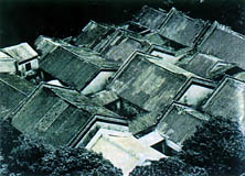 Aerial view of Lin Fong Miu, showing the courtyards.
And so began a Portuguese presence of four and a half centuries in the territory. At that time the peninsula was significantly smaller than nowadays. The sea still lapped at the bases of the hills and the coastal profile was constantly changing due to the movement of the waters and the consequent erosion or siltation. There were only two small villages: Barra, which surrounded Ma Kok Miu, and Mong Ha, around the Kun Yam Ku Miu, as well as a small settlement close to the vegetable gardens of Patane and the little stream of the same name which flowed into the Inner Harbour. The riverine populations lived in their boats, either on the river or drawn up on the beaches.
The lifestyle of the first residents was certainly rather basic. Their buildings were no more than huts built of rushes. We speculate that these would have had a light structure of bamboo (a material which even now is widely used for the most diverse purposes) and would have been covered in straw, which was easily replaceable when necessary.
Feeling themselves to be established and making progress in their trading, the Portuguese soon began to replace such primitive materials with slightly more substantial materials: wooden walls covered with tiles brought by the very native merchants with whom they traded. Even so, the sense of precariousness remained, since none of them could help but remember the downfall of Liampo and Chincheu, which had been destroyed by natives, and from which only around five hundred Europeans managed to save themselves.
The history of the peninsula continued to unfurl, following Chinese history and, naturally, reflecting world history. Between 1555 and 1557, at the behest of the local mandarins and also in their own interest, the Portuguese waged war on the pirates who infested the Chinese coastline, killing and destroying and hampering trade. It is believed that the Portuguese poet Camões would have been involved in some of those battles, as at that time he held the position of "Commissary of the Deceased and the Missing" in Macao - a testament to the administrative organisation already existing then.
With victory having been won over the corsairs, Emperor Kia Tsing decreed that the Portuguese could stay in the territory where they had settled, granting them permission to erect the buildings necessary for their way of life. With the security that this situation brought, little by little a new architecture began to flourish, using bricks and roof tiles: in less than two decades the group of huts had disappeared and a settlement of appreciable size had grown up, surrounded by a "tranqueira" (a stockade of wood, as a means of defence), with a central road serving four irregular blocks of housing, and some public buildings.
The prosperity of Macao attracted the attention of other sea-faring countries, and various attempts at conquest were made, culminating in the Dutch attack of 1622, which was repelled by the city's defenders. It became imperative to build fortifications, even against the wishes of China. From 1607 Philip Ⅱ ordered the construction of city walls, recommending in 1614 that this be done without upsetting the Chinese authorities, who feared that the Portuguese forces would turn against China and only provide explanation or justification for their actions after the attack.
THE DECLINE
After a period of splendour and prosperity which we can call the "golden age" of Macao, especially with respect to its architecture, the city entered into decline from the end of the third decade of the 17th century. Various factors contributed to this situation, namely worsening relations with China (especially after the Tartars entered the country), the loss of trade with Japan and Manila, the constant skirmishing with pirates, internal quarrels, and fighting in Timor. (At that time, the greater part of the Macao economy depended upon Timor, based, as it was, on a monopoly on sandalwood which came from Timor and was traded in Macao. In 1688 a local chieftain rebelled against Portuguese authority and the fighting lasted for around fifteen years. This contributed greatly to the impoverishment of Macao in terms of both goods and men).
In 1684 the Chinese established a customs house on the peninsula. This was the Hopu Grande (large Hopu), in Praia Pequena, beside the Inner Harbour. Later, the Hopu Pequeno (small Hopu), a subsidiary of the former was built in Praia Grande on the Outer Harbour. Thus more taxes were levied on the impoverished inhabitants of Macao. In the last years of the 17th century there were only 150 Portuguese families in the city, compared with 600 families at the beginning of the century.
Faced with this situation, new building stopped and existing buildings deteriorated and could not be repaired due to lack of funds. At that time the city must have been a very sorry sight indeed.
The 18th century was no better. With the truce between Portugal and Holland in 1701, peace returned to the waters of Macao, but not to the city. Internal strife between the laity and the church, and within each of these groups, proliferated. To top it all off, great typhoons swept the peninsula, causing extensive damage. The waters flooded the city, and at times vast areas were under water, further contributing to the deterioration of the buildings.
The Chinese authorities, who had already expelled the Catholic missionaries and forbidden the propagation of the Christian faith within the Empire, stepped up the pressure on the Macao population. In 1749, among other things, the construction of new houses in Macao was forbidden without prior Chinese permission, and only a few works which were considered to be indispensable were allowed, such as the construction of a few Chinese temples.
Nor did the 19th century begin well. The English insisted on "helping" Macao, installing themselves in the city. The opium trade, which was fiercely opposed by China, was conducted from Macao by the English and Americans, which brought new problems. Some African slaves passed through the Portas do Cerco and behaved disrespectfully on the other side of the border, with terrible repercussions. The Chinese authorities continued to rule in the territory while promising to restore the privileges the people of Macao had previously enjoyed. The mandarins rained edicts on them, prohibiting everything from opening roads and building simple walls, to selling copper utensils to Christians or allowing them to ride in sedan chairs carried by Chinese. Meanwhile, a number of fires further aggravated the city's decline: one in the convent of Santa Clara, another in the district of São Paulo in 1825, another that destroyed part of the Chinese district in 1834, and the great fire which razed the new church of São Paulo in 1835, reducing it to the ruined façade which is preserved today.
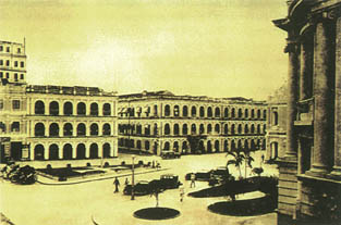 Largo do Senado.
THE REACTION
However, the resurgence of the territory was imminent, due to external causes. The British East India Company controlled the flourishing opium trade, importing opium from the English territory of Bengal to a factory close to Canton, and relying upon the collaboration of Chinese traders despite the Imperial prohibition. Even after the monopoly of the Company had been broken, the opium trade continued, until, in 1839, the viceroy of Canton confiscated the drug and expelled the British from the region. Understandably, England could not tolerate such an affront. In 1840, it occupied Hong Kong and thus began the "Opium War." China was forced to recognise its technological inferiority, and, impotent before the modern military might of the westerners, was obliged to sign the "Treaty of Nanking" in 1842, granting rights and paying indemnities to the foreigners. This defeat of the Manchu dynasty reawakened national pride and led to the Tai-Ping uprising of 1850, which the Qing was able to suppress fourteen years later, with the assistance of their old western enemy.
Following China's loss of power, various countries occupied diverse areas of it, whether by means of protectorates or conquest of territories, and, obviously, the pressure on Macao diminished. Portugal was the only country with interests in the region which did not take advantage of the situation. On the contrary, in order to ensure that it kept possession of Macao and to define the limits of its territory, the Portuguese Government gave up its claims to the islands of Montanha, D. João and Lapa, in return confirming its ownership of the Macao peninsula up to the Portas do Cerco, and of Ilha Verde and the islands of Taipa and Coloane. According to a report in June 1872 by the governor Pedro Azevedo Coutinho, the territorial waters of the province of Macao were delimited as follows: to the north, both in the Inner Harbour and the Roads, by the mean parallel between Ilha Verde and Apo-Seac. To the west, by the edge of Lapa to its S. E. point, from there a straight line to the N. E. point of D. João, following the coast of this island until it meets the meridian in the Prata channel which passes through its N. E. point, then following this meridian until the coast of Von-cam, and from there along the coast of that island until the mean parallel of the bay formed by the S. coast of Coloane and Von-Cam, this parallel constituting the S. limit. To the east, the limit of territorial waters is determined according to the principles of international law. The land between the Portas do Cerco and the Passaleão was considered to be neutral.
Other factors also contributed to the new era of prosperity: the abolishment of the Hopu in 1849, thus ending payment of taxes to China; the arrival of rich Chinese merchants from Kwangtung province, who were fleeing from the rebellion in that region and who brought with them their capital and their creative potential to stimulate business; and also the liberalisation of gambling, which attracted outsiders who came and lost their money in the Macao casinos. Income from the respective taxes provided the funding for various works of public interest.
Finally, we should mention that the founding of Hong Kong had positive consequences for Macao, although there was one somewhat negative feature which might be deemed rather less agreeable: Macao did not regain its old privileges and power. Hong Kong evolved rapidly and combined all the aspects of development which can make a territory "great" - an excellent harbour, an airport, a good internal transport network, flourishing industry and commerce - all to the detriment of Macao, which now had to content itself with a modest second place. However, Macao today has witnessed a series of major works that are practically completed and in operation, such as the new Sea Terminal and Heliport of the Outer Harbour, the Macao International Airport, the new bridge to the islands (Amizade Bridge), the incineration plant on Taipa, the water treatment plant (WTP) in Macao, the deep water harbour in Ka-Ho (Coloane) and the new fishing port, not to mention the constant growth, both upwards and outwards, of civil construction.
URBAN PLANNING
SPONTANEOUS URBAN PLANNING
Urban planning, the organisation of habitable space in order to promote social life, constitutes one of the principal socio-economic structures of humanity, and varies according to models of civilisation. Primitive urban development in Macao followed the models of two civilisations coming into contact with each other for the first time: the eastern and the western. Each left its mark on the building of the new city which began as three distinct and isolated settlements and finally became organised into a single progressive space.
The Chinese buildings, as we will see in the following chapter, were traditionally surrounded by a palisade, which in later constructions became a high wall, enclosing the main house, the outbuildings and a relatively large open-air space. These compounds were haphazardly juxtaposed with each other, leaving small squares and narrow angular alleyways between them, which have lasted through the centuries, resisting subsequent urban development, and are still to be found today. In their turn, the westerners, alone in a strange and perilous land, installed themselves around churches and convents, systematically sited on top of the small hills, initially creating nuclei which were separated from one another. They adopted the Chinese principal of enclosed plots of land, combined with the system of streets lined with houses they brought from their homeland. One may well imagine how chaotic the urban development of the Portuguese areas of Macao was in those early times.
In the early decades of the 17th century various military fortifications were erected to defend Macao from prospective foreign conquerors, and for around two centuries their existence hampered urban expansion, which was limited by the strong city walls of lath and plaster. These walls linked the fortresses and were only broken at long intervals by gates opening onto the outer territories.
Within these limits, the city continued to develop, and those spaces which had been originally left free were progressively occupied. Steep winding roads linked the various zones. There were large squares in front of the main buildings and a frontage road was created along the Praia Grande where the most imposing residences were sited. The number of Chinese residential nuclei grew, still maintaining the traditional structure of Chinese villages. Between the church of S. Domingos and the Porta do Campo was the Great Bazaar, which can be thought of as the first shopping centre of the city. It consisted of various stalls, either open-air or with rudimentary sloping thatched roofs or in the shape of a Chinese hat. The merchandise could be spread upon the ground, in baskets or on crude portable tables. Among the stalls wandered animals peacefully awaiting their turn to be slaughtered for sale. Gambling - even at that time -had its place at various points throughout the Bazaar.
An early industrial zone, in the Rua do Chunambeiro, already had two manufacturing outfits by the middle of the century: a factory for making lime from oyster shells (locally known as "chunambo") and the famous bronze foundry of Manuel Tavares Bocarro. To these, other industries would later be added.
Due to the poor financial situation of the city, there was practically no development during the final part of the 17th century and the whole of the 18th century, and it was only from 1840 onwards, for the reasons already cited, that urban development recommenced. Having survived this difficult period, the territory began to grow anew.
 D. Pedro V Theatre.
The densely populated European nucleus slowly began to spill out from behind its walls, and when large stretches of city wall were later demolished, the whole peninsula was gradually taken over by new residential areas and their accompanying services. The diverse residential clusters, ancient and modern, slowly became interlinked, forming one single, continually expanding, urban area. The first landfill project took place in the Inner Harbour, between Praia Pequena and Praia Manduco. In the levelled - out zone thus created, ten well-ordered blocks of housing sprang up - the first partial development plan of the peninsula. The population of some 25,000 inhabitants around 1840 grew to about 65,000 by the end of the century, creating a demand for new residential districts.
The various plans of Macao which have been drawn up throughout the ages, from primitive perspective maps to the fairly rigorous drawings of the 19th century, allow us to trace the evolution of its urban development, the creation of successive land reclamation and the appearance of new districts. The coastline is altered, the wharves are built that delimit the waterfronts, a few cemeteries are created and green areas are planted in various locales. The illumination of the city began in 1871 with more than 2,000 oil lamps, which represented significant progress for the time.
Industrial development began in the 1880's, with the installation of fifteen fireworks factories, two glass and crystal factories, at least six silk spinning and weaving factories in various parts of the city, and others producing tea and mats. In 1866 a cement factory was opened on Ilha Verde.
Small progress? Indeed it was, but it was the start of a journey which would lead to the great progress of our city today.
The road system laid out during Ferreira do Amaral's government, which linked the central district to the northern streets, was successively amplified, modernizing the system of transportation to the Portas do Cerco and providing even more new areas for construction.
EARLY STANDARDS
The establishment of the Public Works Department in Macao in 1869 helped to reinforce the remodeling of the city, which benefitted from these services. A decree issued on 31-12-1864 had defined the relationship between road width and building height, and this was taken as a starting point in the report of the Commission set up by a provincial order of 28-7-1833, which was charged with studying the "material improvement of the city."
The measures recommended in this report can be understood as a statement of intent regarding urban development, but not a true urban development plan, which was never drawn up, although it was expressly called for:
"As a preliminary to any important improvement carried out in Macao in future, it is absolutely indispensable and imperative to immediately draw up a general plan of the future city, which should be based on a meticulous plan of the present city" (We had to wait eighty years for the first master plan of Macao to be made!).
The Commission based its recommendations on the work of the Directorate of Public Works and the Medical Board, as well as on direct surveys of the various zones of the city. Its concern focused on the following twelve points:
1. Width of roads and height of buildings - This was governed by existing legal precepts, which were generally difficult to enforce in already built up areas. The roads were "tortuous, narrow, varying in width almost with every building", and also problematic was "the direction they took, separating by wearying meanderings two locations which nature has placed close to each other". On this last point, special attention was paid to the need for an "open and direct link" between the Praia Grande and the Inner Harbour, "passing by the senate house." It was recommended that this link be wide enough to allow for tree planting.
Another suggestion was to open up a roadway from the Bomparto Fort to Barra, "either skirting the mountain, following the coast all the way, which would have an excellent effect but would be expensive, or springing over it, which would be more picturesque and incur less onerous costs."
In order to comply with the 1864 decree, it was proposed to proceed by expropriating property, which even then was considered to be impracticable... Only in the Chinese districts was it possible to foresee widening the roads to the desired minimum of six meters, given that the buildings there were not very solid, having a life-span of only around fifteen years, after which reconstruction could be undertaken to comply with the new regulations. For that to happen it was important to "determine now the alignment of future roads, which can only be achieved with reliable information after the above-mentioned plan has been established". It was also proposed that the Public Exchequer should expropriate "the necessary land so that any new building will conform to the designated alignment and within a few years the successive reproduction of this system will have put an end to all irregularities in the current roads."
The Commission recognised that, in order to implement these measures, all that was lacking was "great tenacity in execution (...)" This tenacity unfortunately did not exist, since even today "roads" of less than half the recommended width can be found.
2. Removal of faecal matter - sewers, latrines - The commission suggested various solutions for this grave problem which was so important for public health. Since it was neither viable nor recommendable to use sewage in the existing agricultural area, it was thought to be a better solution to channel it into the sea, "constructing for that purpose appropriate conduits, wherever the width of the road allows". However, it was finally concluded that "the matter is not resolved because in most parts of the city and especially in the Chinese district, the narrowness of the roads, their twisting nature, their numerous and varied zigzags at every step would make construction and even the subsequent flow of liquids so difficult that this system of drains does not appear to be viable ". The Commission finally opted for portable cesspits, to be removed every day. Unfortunately we have no way of knowing whether this solution was applied and if so whether it afforded the desired result...
The existing latrines were also sources of infection, so the commission proposed to replace them with new hygienic installations and to create public urinals, both of which were to be "amply provided with water, which is the essential element of all cleanliness".
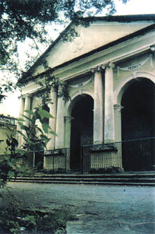
 Casa Branca - Convent of the Precious Blood.
3. Water supply - Macao was never rich in water, especially drinking water, given that "the numerous wells that supply the population draw upon a vein that is almost at sea-level and made up of seepage water which is always somewhat brackish and full of organic matter and therefore not suitable for drinking". On the hill where the Flora Garden is situated there were three springs with good, though not abundant, water, whence better-off families had the precious liquid brought to their houses. There were also the Fonte do Lilau and the Fonte da Barra, which even at that time were already less salubrious. Patane stream had been an important source of drinking water, sufficient for the needs of not only the settlement of Patane, but also for the boats which came to the Inner Harbour wishing to take on fresh water. In time, however, it became completely polluted by the influx of residual waters from the bordering meadows and was eventually converted into a drainage channel, the San-kiu canal, which was later covered over for health reasons.
Two suggestions were put forward by the Commission: to clean up the existing springs and seek new ones in the hills, or to bring the very abundant waters of Lapa island to Macao, in this case noting that "we do not venture to propose this solution in recognition of the inconvenience arising from the water supply being dependent upon the good or ill wishes of a foreign power."
4. Insalubrious districts- The districts of Horta da Mitra, Volong and S. Paulo, parts of the districts of S. Lázaro, Patane, Sa-cong and San-kiu and many spots in the Bazaar were considered to be insalubrious. The radical solution proposed in order to put an end to all those sources of infection was "the razing of all existing buildings and the determining of new street layouts provided with good subterranean drainage ".
Other proposals consisted of filling in the Sa-cong docks, moving them into deeper water, and covering the San-kiu canal "leaving a covered drain in the centre to carry away overflow from the meadows, forming across the whole width of the canal a broad tree-lined avenue linking the Coelho de Amaral Road to the sea."
5. Markets -The existing markets were small and unhygienic. "The main market, known as the S. Domingos bazaar, is located in a dark and narrow place, where meat, fish and vegetables are piled up chaotically and without the most basic notion of cleanliness "; close to one of its entrances stood " a filthy latrine ". The Commission "believed that three markets would be sufficient for supplying the city, therefore recommended erecting a large central market close to the site where that of S. Domingos now stands, and other smaller ones in the Ponta da Rede square and in Patane, besides the new market still under construction on the landfill between Rua de Miguel Ayres and Rua Bispo Ennes ".
6. Abattoir - The existing abattoir did not have even the minimum conditions for hygiene, so the commission proposed to re-position it next to the sea, close to the D. Maria Ⅱ Fort, and to build "annexed workshops, for refining suet, salting skins, and preparing blood (...)", as well as "stables for observing cattle for forty eight hours (...)"
7. Prison - As the prison did not provide security, hygiene or a rehabilitating social climate, the Commission decided that it should be transferred, suggesting for the purpose a plot "at the heights of S. Paulo, a little behind the ruins of the temple of the same name", where there was "ample land for constructing workshop annexes and gardens which the prisoners would cultivate."
8. Other insalubrious establishments - In this classification were included diverse concerns such as the tannery of Patane, sites for drying fish, bone and feather stores, etc. It was proposed to move them all to the land between the D. Maria Ⅱ Fort and Mong Há, or next to the Barra Fortress.
9. Rubbish collection - The rubbish taken from the buildings and the streets was dumped close to inhabited areas, namely, next to the cemetery, between Flora and the Estrada Coelho de Amaral, or the road to the Portas do Cerco. "There is a simple means to put a stop to these nuisances and it consists of obliging the rubbish collector to convey by boat away from the small peninsula on which the city is located all the litter that his carts can carry."
10. Overcrowding of residences and their internal cleanliness - Some considerations reflect a preoccupation with the well-being of the population, suggesting house visits in order to implement hygienic conditions in people's homes; annual whitewashing, inside and out; prohibitions on the cohabitation of people and animals; and ensuring that the amount of air (in cubic meters) was sufficient for the number of inhabitants in each house.
11. Hygiene in the countryside - Along with the improvement projects to be implemented in the city, the commission also considered the agricultural zone. "The cultivated countryside which occupies the whole basin between the river and the mountain range that traverses Macao from North to South is, as a result of the cirumstances of its cultivation, relatively insalubrious".
In order to overcome this drawback, the commission proposed to "prescribe certain rules to improve the level of hygiene in the countryside", such as renewing the water in the paddy fields, only watering the vegetable plots once a day, replacing the ponds used for irrigation with narrow-mouthed wells operated by hand pumps or windmills.
12. Tree-planting - Being fully conscious of the need to plant trees, the Commission noted some of the benefits of this practice: "the purification of the atmosphere, the draining of excess liquids from land surfaces, the regularisation of meteorological conditions", to which it added "the embellishment of the city and the comfort afforded to the populace during the hours of greatest heat." In order to achieve these ends, they proposed two kinds of tree planting: "Firstly that which should be done within the city itself in the gardens and along the roads, and secondly that which should cover the nearby mountains, causing them to lose their arid and bald appearance."
In that era no one yet spoke of ecology, but by extraordinary intuition the planting of trees and shrubs was promoted, so that, little by little, the peninsula came to have green areas. Guia Hill was planted with trees, and the gardens of Vitória, S. Francisco, Flora, Montanha Russa, Chunambeiro, Gruta de Camões, and Lu-cau (nowadays called Lou Lim Iok) were created. When new roads were opened to the north of Tap-Seac, all the houses had to have a small garden at the front.
From this report we can conclude that the sanitation of the city, which had begun to be implemented during the tenure of Tomás de Sousa Rosa, the author of the order which had originated it, was at last carried out.
EARLY PLANS
The Horta da Mitra district, which had been rebuilt with the same unsanitary conditions after a fire in 1865 had destroyed 200 huts, housed 60,000 people in closely packed houses served by a tight network of alleys. It comprised the area between Rua do Noronha and Rua da Colina, Rua Nova a Guia and Rua Henrique de Macedo, and part of Rua do Campo. It had once been a forest where a group of Chinese emigrants had settled. For quite some time these emigrants lived by selling the firewood they cut there, thus successively increasing the area of the small village. The lack of hygiene transformed it into a source of infection, a problem that only total demolition could resolve. On this site a new district was then built in 1886, later named the Tomás Rosa district. Within its rectangular layout, amidst straight paved roads, it boasted airy houses with good light, a municipal market complying with strict health regulations, and a new temple, the Chong-Kuok-Tou-Tei-Miu (Chinese temple of the Earth God), to replace the demolished "Pagoda of the Household Gods".
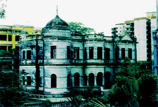
 Vista Alegre - Leng Nam School.
Governor Horta e Costa took up the initiative again, ably seconded by his director of Public Works, Abreu Nunes. He began his work in 1894, in the district of Tap-Seac, which was bordered to the west by the Rua de Esperança, to the south by part of the Estrada do Cemitério (Cemetery Road), to the north by Rua Adolfo Coelho and the east by the Avenida Conselheiro Ferreira de Almeida. In that place there was a meadow lower than the surrounding roads in which the local farmers retained rainwater in improvised dams and used natural fertilisers, thus causing unhealthy conditions. To resolve this problem, after expropriating the property, the area was filled in with earth taken from the Campo da Vitória half way up the hills of Guia and Flora, at the same time creating on the slope an avenue (which has since disappeared) parallel to the present day Estrada da Vitória and the Avenida Sidónio Pais. Once levelled in this way, the meadow was divided into blocks for housing.
The Bairro do Volong (Volong district) was another breeding ground for infection. It was situated in the bamboo grove which in 1622 had obliged the Dutch to deviate from their invasion route, for fear of ambush, and attempt to scale Guia Hill. This hesitation led to their defeat and earned the spot the name of "Campo dos Arrependidos" (Field of the Rueful). It was later acquired by Francisco Volong, a naturalised Portuguese of Chinese birth and became known as the "Horta do Volong", or Volong's Vegetable Garden, degenerating over time into an insalubrious and crowded district. Following an epidemic of the plaque of which it was the epicentre, it was expropriated in 1895 and completely demolished. Two years later, furnished with rectilinear roads in a rectangular grid, a drainage system, and even foundations for the houses to be privately erected there, it was handed over to the Leal Senado. The extensive "Horta do Volong" was located, for all intents and purposes, in the place of the present district, between the Estrada do Cemitério to the north, Rua de S. Lázaro (probably the present day Rua Nova de S. Lázaro) to the west, Rua Ferreira do Amaral to the south and, to the east, the Avenida da Flora, (which no longer exists) possibly even stretching beyond the present Estrada da Vitória. It was, however, partially swallowed up by the S. Lázaro district.
This district developed around the Nossa Senhora da Esperança Church and the S. Lázaro Hospital which had been built to treat lepers. It mainly consisted of humble cabins, with only a few nicer houses along the road leading up to the church. Since most people were reluctant to live in the area for fear of disease, only the most miserable did so, joined shortly afterwards by a few Chinese Christian converts. The S. José chapel was founded for these converts so that they did not have to attend the church of the lepers, until, in 1663, the main church was opened to all. The sanitary conditions in the area were dreadful, and the plague of 1895 found there a fertile ground in which to spread. For this reason, by an order of 30 June 1900, Governor Rodrigues Galhardo ordered the district to be completely demolished, including the aforementioned chapel. Only the church dedicated to Nossa Senhora da Esperança (Our Lady of Hope), which was completely rebuilt in 1885 by order of Governor Tomás Rosa, was saved.
THE COAST LINE
The progressive siltation of the Macao coastlines provoked two reactions: on the one hand, the exploitation and consolidation of the reclaimed land to the east and west of the peninsula for future urban planning, and on the other hand, the promotion of studies on the creation of new ports where deep draft ships could berth. In 1869 land reclamation work began next to Chunambeiro which would make possible the cleaning and organisation of the area, at a spot where the road from the city centre terminated. In 1873, this road was extended to the Bomparto Fortress, as a result of further land reclamation, thus becoming a continuation of the beautiful tree-lined avenue along the frontage of the Praia Grande, along which the best buildings of the period were constructed -homes, small palaces, and public service buildings.
Meanwhile, on the Inner Harbour side, the land reclamation near Barra, which was begun in 1868, improved access to the area of the A Ma Temple, by way of a harbour road linking it to Patane, subsequent to the occupation of the old bays of Praia do Manduco and Praia Pequena. In 1873 the governor, the Visconde de S. Januário, ordered the land-fill to be extended along the Inner Harbour to the Barra Fortress, and drainage facilities to be installed along the roads next to the Bazaar. These works were concluded in 1881. The Patane dock was completed in 1887.
In 1884 a project for the port of Macao was drawn up by Adolfo Loureiro. Essentially, it aimed to regulate sea currents by means of various works along the coast, to build wharves and link Ilha Verde to the peninsula by land reclamation, creating a dyke and filling in the river. A new district was to be constructed on this isthmus with a large avenue and transverse roads forming several housing blocks. It was not until quite some time later that the principles governing this plan were realised, at least in part.
The construction of the Ilha Verde isthmus was ordered by a decree of 1890 during the governorship of Councillor Borja, with several aims:
- To increase the main flow of the river current by eliminating a secondary channel, so that the tidal system would help to keep the other channels open.
- To promote the cleanup of the seafront where all kinds of detritus had accumulated.
- To link the peninsula to the small island whose ownership was contested by the Chinese authorities of the time.
These works continued into the early years of the 20th century when a general city improvement plan was implemented, which included installing water and drainage systems.
Admiral Hugo Carvalho de Lacerda Castelo Branco, a hydrographer who worked in Macao between 1918 and 1927 as director of Harbour works and as interim governor, wrote a report listing the results of work carried out at that time as well as projects which were never actually realised. Besides social, economic, political and cultural questions which do not concern us here, he refers to the idea of a reservoir on Taipa to hold rain and spring water, exactly like the one which now exists, as well as others in Guia and Coloane which were never built.
He also refers to various attempts throughout the years to improve Macao's harbours, with a series of successes and interruptions, drawing particular attention to the artificial harbour of Rada which was planned and built between Praia Grande and Macao-Seac and which had two sea walls to the east and the south. However, the general plan was more ambitious. The proposal was to build a large artificial island between Macao and Taipa, Rada Island, which would include a system of canals, docks, defensive dykes, etc. The access channel to the harbour required frequent dredging to keep it clear, and it was the dredgings that would provide the material to build the island, which in turn would contribute to a better regulation of the river current by channelling it and protecting the dredged areas, thereby preventing further siltation. However, this plan, like so many others, was not put into effect, and we do not know why.
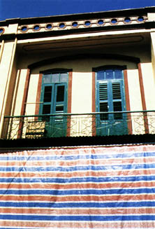 The verandas of traditional buildings (the old headquarters of the Clube Argonauta). Photograph by Joaquim de Castro.
A new, detailed study was made in 1929, based on different premises and therefore presenting a different solution.
PLOT PLANS
Various plot plans were put forward, namely for the coastal areas, and, from 1900 onwards, for the districts of Avenida Horta e Costa and Avenida Ferreira do Amaral, including street plans which would come to be important transportation routes. The S. Lázaro district was completed, and the public housing districts of Tamagnini Barbosa and Hipodromo were built. More landfills along the Praia Grande and in the Outer Harbour provided yet more land for construction. By the middle of this century the city had doubled in area since the end of the last.
MASTER PLANS
However, there was no master plan linking the various zones; the first such plan only appeared in the 1960's, drawn up by Garizo do Carmo. Its main goals were the preservation of the older districts, the exploitation of free spaces, and the definition of an industrial area between Areia Preta and the Outer Harbour, for which an adequate road system was recommended. The plan maintained the areas traditionally used for harbour-related activities, trade, warehousing and lower income housing. It proposed using the new land at Praia Grande and the Outer Harbour for luxury commerce, hotels and more important services.
Thus began the presentation of a series of urban plans that has continued until the present day. In the 1970's various plans proposing different solutions to Macao's urban problems were drawn up.
In 1976, architect Tomás Taveira drew up a plan recommending urban renewal, with new development areas on the islands, in order to solve the problem of congestion in the old nucleus. It set out new industrial areas and proposed new low-cost housing districts.
Meanwhile, the Overseas Development Administration had begun work on a "Territorial Map of Macao." This was initiated in 1970 and concluded in 1978, not by the Directorate of Public Works of the Ministry which had originated it, but by the body which replaced it, the Ministry of Inter-Territorial Cooperation. When it was finally presented in 1979, this plan was found to be already out of date, where upon the Government of Macao asked Profabril, a private company, to revise it, in order to have available a physical map of the territory to guide their decisions on urban development.
This "General Development Plan for Macao" was intended as a starting point for urban development based on future specifications for which it would supply the general parameters. The plan recommended massive land reclamation schemes, first on the peninsula and, in the long term, on the islands too. It focused on socio-economic programmes, the protection of cultural heritage, the planning of green spaces and the urban fabric, and a general transportation policy. All of this was subject to the availability of technical and financial resources and to the legislation which would have to be implemented. One of the essential elements of this plan was the intention to create a completely new city in the areas reclaimed from the sea on the east coast of the peninsula.
In the same year, the architect José Catita drew up another "General Development Plan", highlighting the priorities for intervention in the road network and proposing a group of urgent measures. These included the implementation of plot or housing estate plans, the revision of existing plans, the study of infrastructure, and the construction of the Flora Tunnel and the related road links and landscaping. Several phases of land reclamation were also mentioned, in anticipation of the airport and the new sea port. Land use complied with given percentages, and occupancy levels were set for residential areas.
In 1984 a Stuttgart company, with the help of architect Castelo Branco, proposed drawing up a "Master Plan for the Territory of Macao". Included in their objectives was the creation of incentives for private development, the co-ordination of government resources for land use and infrastructure development, the improvement in quality of life and working conditions, the preservation of Macao's historical, cultural and natural features, the determination of the best sites for housing, industry and services, the revision and integration of existing plans to ensure their continuity and, finally, the promotion of this development process among both private and public sectors. From among the various elements of the plan, the following stand out: territorial land use and hierarchies for its use, the transportation network, infrastructure, green spaces, and, obviously, the areas destined for construction.
In 1986-87, the firm Asia Consult drew up a new master plan to include the islands, with the collaboration of the architect Luís Rebolo. This plan was immediately subject to revision. It aimed to define the general precepts for building density and transportation, and methods of implementation. It was concerned with providing enough land to meet foreseeable housing needs, creating premises for various economic activities and social facilities, curbing excessive growth on already developed land, protecting and exploiting green spaces, improving links to the outside (airport, harbour) and internal transportation (street maps and the new Macao-Taipa bridge), reviewing the infrastructure (water, drains, rubbish collection, electricity), and rationalising urban management. The plan anticipated intensive occupation of the peninsula which would exhaust the available capacity; the progressive launching of new land reclamation projects; the control of urban sprawl; and the safeguarding of the most important landscape and heritage features. In Taipa, it was concerned with the development of the Baixa da Taipa, and the preservation of the principal natural areas and the coastline; in Coloane, it was concerned with the preservation of the island as a natural zone and the maintenance of the coastline. A point deserving special mention in this report was the planning of land reclamation, which was analysed from the perspective of its impact on the landscape and the hydrographic environment, as well as its adequacy for projected use.
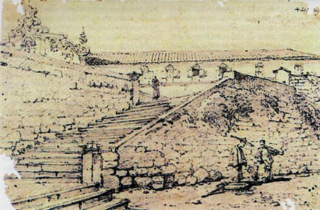 Steps leading to the old Santo Agostinho Convent. George Chinnery, 1829. Col. Sociedade de Geografia de Lisboa.
BLOCK PLANS
All these general plans, drawn up over three decades by diverse authors, obviously present different ways of approaching the subject, and it is not easy to render them compatible. In spite of this, they have provided the basis for various specifications which have regulated construction on the peninsula and the islands.
In 1987, a regulation was made for the use of the site of the old Liceu Infante D. Henrique, dividing it into four sections, one of which was destined for public recreational purposes. The alignments, volume measurements and purposes of the finished buildings were defined. Outline designs showed the siting and height of the different blocks, establishing the respective maximum, minimum and fixed values. The completed project differed somewhat from this regulation, given that it included the highest building in Macao: The Bank of China, with its 42 stories.
THE PRAIA GRANDE/ZAPE
One common feature of these disparate general plans was, as has been mentioned, the recognition of the need to carry out more land reclamation and exploit the new areas thus created.
When it became clear that there was insufficient land on the peninsula for the desired expansion, this reclamation became a reality and was used in different ways. Part of the Praia Grande Bay was filled in with compacted soil and divided into blocks by wide roads. In the space between the city and the strip of sea separating the peninsula from the island of Taipa, two large landfills were created, called by their initials: ZAPE - Zona de Aterros do Porto Exterior (Outer Harbour Reclamation Zone) and NAPE - Novos Aterros do Porto Exterior (Outer Harbour New Reclamation Zone), this latter still being under construction.
The first Urban Development Plan for the Outer Harbour and Praia Grande was made in 1964 by the architect Leopoldo de Almeida. Although this plan is essentially for the Outer Harbour reclamation zone, the proximity of the two zones led to the reorganisation of part of the Praia Grande in order to solve the traffic problems and, simultaneously, to create tree-planted open spaces.
The programme recommended a separation/ link between the new area and the existing city. This aim was achieved, on the one hand, by opening up Avenida Rodrigo Rodrigues from the coast, by the Hotel Lisboa, to the Reservoir in the extreme N. E. On the other hand, two links with the city centre were designed: one passing through the valley between the S. Januário and Guia hills (forming an extension of the Calçada do Gaio/ Calçada do Paiol) and another carved out half way up Guia Hill (Estrada de Cacilhas) making it possible to reach Areia Preta without going around the reservoir. Almost all of the area under study was intended for residential purposes, with provisions for green areas and sporting facilities also. In addition, the possibility of building a Marine and Air Terminal in the extreme eastern part was considered.
Given that the plan was not put into immediate effect, it was soon considered outdated, and so another study was done in 1979 by the Prescott Group, with the architect Lima Soares as the consultant in charge.
This plan was concerned with adapting development to local climatic conditions, paying special attention to the north-south direction, between the sea and the hills, which boasted excellent ventilation and panoramic vistas. The non-built-up areas were destined for public use, with an emphasis on pedestrian circulation - various green areas were projected, which would later be equipped with leisure and sporting facilities. The buildings would be between 15 and 19 stories tall, but not exceeding 60 meters in height, in order to preserve the presence of Guia Hill. As a general rule, it was obligatory to build a colonnade, thereby forming an arcade.
The road system was based on two parallel routes, the Avenida Dr. Rodrigo Rodrigues and the Avenida da Amizade, which would be crossed/ joined by secondary roads. The proposal also included an access ramp to the Estrada de Cacilhas on the bank of the Reservoir, a passage under the Estrada dos Parses with a small embankment linked by a tunnel to the Calçada do Gaio, and, no less important, the opening of a tunnel through Guia Hill.
Another essential factor was the S. Francisco junction, next to the Hotel Lisboa, which was the subject of a special study submitted two years later: the Block Plan for the Transition Area, with detailed solutions for the various existing architectural elements.
The same company then went on to develop a new study for the area under the guidance of the architect Eduardo Flores. This plan was presented in 1985 and subject to a series of compromises, in light of the existing infrastructure. This plan maintains the principle of preserving Guia Hill, proposing a height clearance of 60 meters, except in designated areas where the clearance is raised to 90 meters.
This plan proposes to regulate building density and determine the standards for urban construction and exterior finishings, superseding the regulations in force. Its rules are specific for each block and are relatively detailed. The link between Calçada do Gaio and an embankment and tunnel under Estrada dos Parses is maintained, as is the extension of Avenida Dr. Rodrigo Rodrigues to the south, though both are adapted to conform to the Urban Intervention Plan for Guia and S. Francisco hills. An area is reserved for access to the projected tunnel through Guia Hill. The hill slopes are treated as total nature reserves, and there are also areas of partial reserve, where use is restricted to public and recreational facilities.
The plan specifies pavement types, urban landscaping, tree planting etc., with the aim of creating a pleasant environment. A system is established whereby buildings must be set back from the roadside, giving rise to pedestrian corridors along the dividing lines of the blocks. Arcades are also obligatory wherever there are upper floors stipulated in the plan.
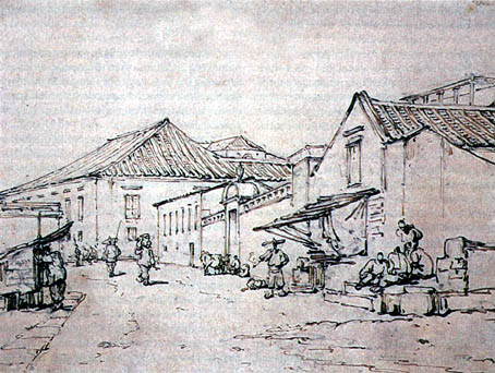
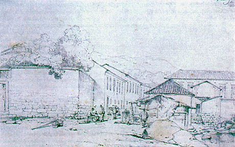 Street scene with contemporary architecture. George Chinnery, 1830 approx. Col. Toyo Bunko.
NAPE
As a logical continuation of this area, a New Outer Harbour Reclamation Zone arose to the south and came to be known by its initials NAPE (Nova Zona de Aterros do Porto Exterior). This development plan was drawn up, starting in 1982, by the Palmer and Turner Office of Architecture and Planning under the responsibility of architects Siza Vieira and Fernando Távora.
The point of departure for this plan was the importance of the site, which was intended to constitute a pleasant "entrance hall" for those arriving in the territory by sea. It would project like a primordial element from the urban landscape around it, outlined against the background of the distant Lapa mountains.
The study concentrated on two distinct areas. The first phase was to the south-south-east of the ZAPE nucleus and separated from it by a canal running along the northernmost avenue of the zone. Access would be via a bridge over the canal, extending the central tree-lined walkway of ZAPE, which held an axial position here, inter-linking all the internal roadways, to the new coast line. The second phase was at the north-north-east extremity of, and accessed by, the northernmost avenue, with a second link to the peninsula via an isthmus to the north of the Reservoir on which low cost housing would be built. This landfill area was destined for industrial purposes and a polytechnic school surrounded by green areas.
The "Master Plan for the Macao Territory" previously referred to caused significant alterations to the NAPE plan, namely the reduction of the landfill area, which led to modifications of a general nature. The second phase lost its importance and was reduced to some supporting facilities for the maritime Passenger Terminal and boxes for the Grand Prix. The first phase, now called "Zone M", was the main object of the revision carried out in 1987, which implemented changes due to the new reduced area and projected use. This revision sought to adapt the proposals of the original plan to the new general framework for development of the territory, bearing in mind its interaction with adjacent areas and proposing a coherent relationship between the various features that would form this urban expansion zone. The ZAPE plan to the north affected this study to some extent, influencing building height and stipulating the road link points.
A new intermediary solution was proposed, which maintained the general concept of the earlier plan while adapting it to the new set of requirements. A minimum area of 35 hectares was stipulated, which would permit a scale corresponding to the importance of the site and the implementation of coherent urban planning. The length of the canal between the landfill and the existing coast was increased, anticipating future use of this space for recreational activities, and the preservation of water quality was to be ensured by creating a system of automatic tide valves at both ends of the canal.
The road structure maintains the former north-south and east-west grid, with the last avenue to the south being eliminated and replaced by a pedestrian area. In the east-west direction, two routes have a lower profile, alternating with three avenues parallel to the coast line. The perpendicular roads all have the character of avenues, but their profiles are altered by the positioning of the tree borders. The landfill is accessed via two roads running in opposite directions, on either side of a central shaded walk reserved for landscaped spaces, in extension of the tree-lined walk anticipated in ZAPE. The whole automobile road network is based on this entry/exit. Pedestrians also have the use of two viaducts spanning the canal at its eastern and western ends over the sea walls, which will connect with the pedestrian area to the south via two coastal walkways along the edges of the landfill.
The new area is essentially designed for residential buildings, with space for commerce, equipment and parking on the first two floors. These will form a continuous frontage along the roads, above which will rise the apartments, up to a maximum height of 30 meters and occupying around 80 per cent of each block. However, other uses are also anticipated: a hotel may be sited on the south-south-east perimeter; an area to the east will be reserved for future school and/or sporting facilities; and a medical clinic will be built next to the square to the east. Until these projects are realised, the sites reserved for them will be used as green zones.
This enumeration of planning studies is not exhaustive. I believe that there are others which have not been cited here due to the difficulty of locating them.
However, revisions are constantly being made to the existing plans, motivated by problems arising from their implementation as well as by new partial plans for the areas not yet covered in the specifications.
And the city does not stop growing!
ARCHITECTURE
ANTECEDENTS
In order to understand the layout of early Macao and the anatomy of its buildings, we must focus first on the traditional form of Chinese houses.
Nowadays, when we come across ancient buildings isolated in the traditionally Chinese districts, it is certain that they are remainders of old courtyard quadrangles, the most widespread system in all China, with minor variations. According to this system, four buildings are distributed one on each side of a square space, leaving a central courtyard onto which all of the rooms open. Even today, vestiges of this custom can be found, in contemporary buildings, in which the doors to the various divisions of the house open directly onto the living room, which stands in for the old central courtyard.
Generally speaking, the building to the north with its southern façade overlooking the courtyard was called the major house because it had the best position (warmer in winter and cooler in summer). This was reserved for the head of the family or the members of the older generation. Other family members were spread out in the side buildings, and the building at the opposite end was used for children and servants. The entrance to this compound was usually in the south-eastern corner under a covered area, which was limited by the end wall of the side building and formed a porch with a second doorway into the courtyard.
The quadrangle courtyard takes on distinct characteristics in different regions of China, due to the diversity in climate, building materials and customs. In the north, where the climate is dry and cold in winter and cool in summer and where there is plenty of space and relatively few people, the courtyards are quite large. In winter, more light is able to enter the buildings. The four sides are not directly linked with each other. But in the hot and humid south, where there is a large concentration of people with consequently less space allocated to them, the courtyards could not be very large. The buildings on the four sides were linked into one unit around a small courtyard which provided light and sun, ventilation and inter-connection between them. At times, the structures on the four sides had two storeys, which helped to make the courtyard seem even smaller. This type of house was sometimes referred to as carimbo (rubber stamp) because of its shape.
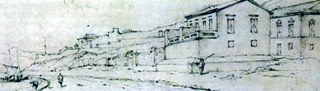
 Praia Grande seen from the S. Pedro Fort. George Chinnery, 1834 approx. Col. HKMA.
The dimensions of these compounds varied according to the owner's economic status. In some cases, new north-south facing compounds were added, forming additional courtyards. More rarely, if space was an issue, this extension could be added in an east-west direction, but in either case, the most important apartments were always the axis of the compound. This organisation was appropriate for the old Chinese Confucian ethic, separating as it did the old and young, masters and servants, and emphasising hierarchical relationships of "higher" and "lower."
EARLY SETTLEMENT IN THE PENINSULA
When the Portuguese arrived in Macao they found two temples, one in Barra and the other in Mong Há, each surrounded by its own village.
The Barra temple, Ma Kok Miu, had been built at the start of the Ming dynasty and altered during the reign of Wan Li, who governed China between 1573 and 1621. The system of courtyard construction has been adulterated here because of the constraints imposed by the terrain. The courtyards follow on from each other on different levels, climbing the mountainside. The entrance level, protected by a granite wall subdivided into sculptured panels and reached via a short flight of steps guarded by stone lions, has a double portico dedicated to Sin Fong, "he who knows everything at first hand;" to the right is the main temple in which the goddess Neong-Ma is worshipped, with a circular side entrance carved from a single piece of granite. Behind is the turret of the crematorium for offerings, in the form of a pagoda. Between these temples are two large rocks engraved with images of the ship that carried the damsel of Fukien, who, according to legend, metamorphosed into the goddess as she climbed the slope. Granite steps lead to the second courtyard where the temple to Tin Hau, Queen of the Sky, is situated. Another flight of steps leads through rocks and pagoda trees to the third courtyard, where we find a temple to Kun Yam, the Goddess of Universal Benevolence, which was built during the Qing dynasty.
The Mong Há Temple, dedicated to Kun Yam, was built into the hillside, which limited its growth. It therefore has only one courtyard with the chapel of the goddess, and, to the left, a pavilion dedicated to Seng Wong. It is not known when this temple was founded, only that additions were made in the 17th century.
The first Portuguese settlers in Macao established themselves on the west coast, beside the Inner Harbour, close to the A-Ma temple. Although their initial situation was precarious, after their victory over the pirates and the subsequent permission from the Chinese Emperor for them to inhabit the peninsula, they began work on a new settlement, a little further north.
Since the propagation of the Christian faith was one of the motivations for the Voyages of Discovery, representatives of various religious orders always accompanied the expeditions, leaving traces of their passage in their wake. As in other places, in Macao they built churches and convents, schools and hospitals.
The first Christian house of worship to be built on the peninsula was the S. António Chapel, between 1558 and 1560. At that time Macao belonged to the diocese of Malacca, created on 4-2-1558 by the Pro Excellenti Praeeminentia Bull of Pope Paul IV. It was roughly built of wood and was victim to several fires, in 1608, 1809 and 1874, being re-built each time. The current building, in neo-classical style, dates from 1875, with the façade and tower having been renovated in 1930, as a granite plaque on the front announces.
At the same time the S. Lourenço Church was built. It was re-built in lath and plaster in 1618, and repaired between 1801 and 1803. Between 1844 and 1846 it was totally remodelled according to the taste of the period by the Macanese architect José Tomás d'Aquino. Its European characteristics made it different from the other churches in the city, especially in the width of its single nave, only broken by the existence of two small side chapels, thus forming a reduced Latin cross. Further renovations were carried out in 1897-1898 and in 1954.
The third Christian house of worship to be built was a small wooden chapel dedicated to the Nativity of Our Lady, which was elevated to the status of cathedral in 1576, after the creation of the diocese of Macao by Pope Gregory ⅩⅢ's Bull Super Specula Militantis Ecclesiae, of 23-1-1575. The cathedral was replaced by a lath and plaster construction in 1622 or 1623, and newly rebuilt in1844 by Tomás d'Aquino, on the same site but with a different orientation. The new façade faced north, since the old west-facing façade had partially obscured the Episcopal Palace. After the earthquake of 1874, major works had to be carried out, namely on the towers and the roof, but without altering the layout.
The first Jesuit house, created in 1565, was in one of the casinhas térreas (low houses) made of straw, next to Santo Antonio's chapel. It was there that Bishop D. Melchior Carneiro stayed temporarily when he arrived in Macao in 1585, until his own residence could be built. It caught fire in 1596 and was rebuilt and enlarged in 1597 on the site adjacent to the S. Paulo Church.
Bishop D. Melchior Nunes Carneiro Leitão, S. J., bishop of Nicaea, Patriarch of Ethiopia, was not the bishop of Macao, but "Governor of the bishopric", as bishop of China, Japan, Korea and adjacent islands. He was the main instigator of urban improvements in his time, founding, in the same year that he arrived, the Confraria da Misericórdia (a charitable institution), the S. Rafael hospital and the S. Lázaro hospital.
The Confraria da Misericórdia became the Santa Casa da Misericórdia, which has always given aid to the poorest of the poor. The initial building included a church, consecrated to the Visitation of Our Lady, which was demolished in 1883 because of its ruined state. At the beginning of the 19th century, a false façade was added to the building, in the neo-classical taste of the time.
The S. Rafael Hospital was created to serve Christians and pagans, rich and poor. The Senate doctor was the first to be responsible for hospital services and its pharmacy, where the first vaccines in this part of Asia were administered. After various repairs and alterations of use, the hospital building was recently adapted for use by the Monetary and Foreign Exchange Authority of Macao.
The S. Lázaro Hospital was intended for the treatment of lepers, and the Nossa Senhora [Our Lady of Hope] Chapel, normally known as S. Lázaro, was built next to it. The hospital was demolished along with the district in 1900. The present church was re-built in 1885 on the site of the earlier church, of which only the transept, dating from 1637, remains.
In 1572, an elementary school opened next to the Jesuit residency, from which the S. Paulo college later developed, and this was elevated to the status of University in 1594. As their first church, which was still built of straw, had burned down, the Jesuits constructed another in wood with a tiled roof. This too was replaced, in 1573, by a lath and plaster construction, dedicated to the Mother of God, with the Jesuit governor D. António Vilhena personally paying for the cost of tiling the roof.
In 1580, on the hill behind the residency, Father Miguel Ruggieri founded a house with cells for Chinese catechumens, in a corner of the college site. It had a chapel dedicated to S. Martinho de Tours, and stood on the site where the "ruins of S. Paulo" now stand.
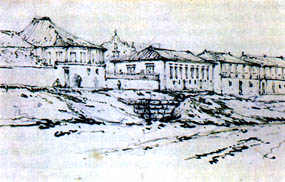
 View from Praia Grande towards the Bom Parto Fort. George Chinnery.
Pencil and ink on paper. 1833-36 approx. Col. HKMA.
View from Praia Grande towards the Bom Parto Fort. George Chinnery.
Pencil and ink on paper. 1833-36 approx. Col. HKMA.
When the Madre de Deus Church again caught fire, it was abandoned by the Jesuits, who resolved to move it to the site of the aforementioned chapel in 1586. There was another fire and another reconstruction, with lath and plaster walls and a tiled roof. The re-built church, again dedicated to the Mother of God, was inaugurated on Christmas Eve 1603, with great pomp and solemnity. But the misfortunes had not ended: after the expulsion of the Jesuits from the territory, troops were billeted in the College, and, in 1835, a fire which started in the kitchens completely destroyed the college and the church, with the sole exception of the façade we know today.
In 1547 the Portas do Cerco was built, with barracks for Chinese guards above it. This structure collapsed and was rebuilt in 1674, and the barracks moved into an annex. The current Portas do Cerco is integrated into the Macao-China frontier.
In the Patane area there was a fort called Patane or Palanchica. No one knows exactly when this fort was built, although 1625 is the popularly accepted date. It formed part of the city wall linking the Inner Harbour to the Monte fort, and its purpose was to protect the city from a possible Chinese invasion. It was made up of three platforms, each with a piece of artillery, as can be seen from drawings of the time. It was demolished around 1640, along with all the stretch of wall to which it was joined.
Throughout the last decades of the 16th century, the Portuguese were building their houses and marrying the locals. According to documents of the time, in 1578 there were ten thousand inhabitants and five churches, with around two hundred Portuguese houses.
In 1579, the Spanish Capuchin priests founded the Nossa Senhora dos Anjos Convent, later known as the S. Francisco Convent. It was built on a spit of land surrounded by water on three sides, in the extreme northern part of the Praia Grande Bay. It had a spring with good water and enjoyed, naturally, a beautiful view. On the small overhang to the north, the Nossa Senhora do Rosário Chapel was built, on the site now occupied by the S. Januário hospital. For some time, a small seminary existed there. A convent of Clarissas (nuns), who had come from Manila and had their own private church, existed here as an annex from 1633 until the end of the 19th century.
The Leal Senado, founded in 1583 when Macao was elevated to the status of a city, would originally have been installed in a single storey building, later substituted by the present building, as we will discuss later.
In 1586, the Spanish Augustin friars bought a casinha (little house) in order to found what would become the Nossa Senhora da Graça Convent. As occurred with the Franciscans, the Spanish priests were replaced by Portuguese in 1589, and in 1591 the convent was moved to the heights of the city, close to the present Largo de Santo Agostinho where the Nossa Senhora da Graça Church was also built.
The Dominicans arrived on the peninsula in 1587. The provisor of the bishopric allotted them some wooden houses, where they founded the Casa de Santa Maria do Rosário de Macao, with a chapel of the same invocation, also built of wood. When the Portuguese Dominicans took charge of these premises, they created a hospital there for religious orders passing through Macao, and also a school for instruction in reading, writing and Latin, and later a course in art. In 1590 they built the S. Domingos Church, in a mixture of western and local styles, which was suitable to the climate the building materials available then. The convent was re-built in 1721, at the initiative of its vicar, brother José da Cruz.
In 1592, the Lin Fong Miu, or Lotus Temple, was built at the foot of Mong Há hill, beside the present Estrada do Arco. This became the place where high-ranking mandarins stayed when they visited Macao. The traditional architectural form has been largely used here, with courtyards following each other in both directions.
In 1594, the Senate and the people pooled resources for the re-construction of the São Paulo college, which was the first University in Macao, and even in the whole Far East. On the 1st of December of that year, the program of General Studies of the Madre de Deus College was created, with faculties of Letters, Philosophy, Moral Studies, Canonical Law and Theology, which conferred degrees of Master of Arts to the laity and of Philosophy and Theology to those in holy orders. Functioning as annexes to the University were the Seminário Nipónico de Santo Inácio, founded in 1623; a seminary for the children of Portuguese settlers; and the Procuratorship of Japan. This boasted a large library containing thousands of books and a wood block printing press as early as 1585; another printing press, with moveable type, was installed in 1588. The city coffers were also moved here, since it was considered to be the safest place on the peninsula.
On Ilha Verde, known at the time as ilha dos diabos (Devils' Island), the Jesuits built, in 1603, a thatched house and chapel, which under went various alterations throughout the years, as they were demolished and re-built according to the tastes and wishes of the authorities at different times. In 1617 some two-storey houses and two chapels -dedicated to Nossa Senhora de Santiago - were authorised. These were pulled down by order of the Senate in 1621 and later re-built.
In 1625 a Casa de Fundição (foundry) was established in Macao. It was managed by two Spaniards; Manuel Dias Bocarro, who would later become a founder of great renown, trained there, moving on to manage the foundry in the Largo de Chunambeiro the following year. It produced artillery parts and bronze bells for the Portuguese fortresses in the East and even for Portugal.
 Street scene. Macao. George Chinnery. 1837 approx. Col. Toyo Bunko.
The present Kun Yam Tong temple was built in 1627, close to the old Kun Yam Ku Miu. Since the reign of Wan Li, who ruled China from 1573 to 1620, there had been a Buddhist Temple there (P'ou Tchai Sim Un), successively enlarged with new pavilions, built on three ascending levels. Behind the third temple is the cemetery for monks belonging to an esoteric sect. The temple was built of grey brick, with a granite staircase and balustrade. It is decorated profusely inside with multi-coloured glazed earthenware reliefs representing religious scenes, covering the upper part of the walls under the eaves of the green glazed roof and in friezes along the ridge-pieces.
According to an account of the time, written by the Macanese friar Paulo da Trindade, Macao was, in 1630, the second largest Portuguese city in the East (after Goa), with "large and sumptuous buildings and large houses with wide courtyards and gardens".
In 1633 the Santa Clara Convent was founded by Spanish Clarissas. Today, only part of the convent wall remains, next to the Santa Rosa de Lima college. In the same year, the Jesuit Visitor, Father André Palmeiro, ordered the construction of Nossa Senhora do Amparo Church. It was created as a catechumenate for the Chinese, not far from the São Paulo college, outside the city walls. The São José Seminary was founded by the Jesuits in 1728, in the Rua do Mato Mofino, close to the São Lourenço Church.
FORTIFICATION
If the 16th century was one for building the first churches, the 17th century can be considered as the period of fortresses, some of them linked to the new churches (while some of the already existing churches were re-built: São Paulo in 1602, Santo António in 1608, São Lourenço in 1618, the Cathedral in 1623).
The oldest defence installation must have been the above-mentioned Patane (or Palanchica) Fort, close to the Santo António Chapel.
The majority of the fortifications were constructed from 1622 onwards, sometimes in places where there already existed ramparts, which had formed a first line of defence. At that time, the city was surrounded by a wall of lath and plaster, which began in Patane where there was an arched gate called the Porta do Santo António or the Porta de São Paulo. The wall followed the coastline of the Inner Harbour to the west, then headed for Monte Hill to the São Paulo Fortress adjoining its north-west bastion. From the south-east bastion of the same fortress, the wall descended to the São João Bulwark, next to which was the Porta do Campo or Porta do São Lázaro. It then turned towards the São Jerónimo Fort and ended at the São Francisco Fortress, at the northern end of the Praia Grande Bay.
Another stretch of wall, to the south of the peninsula, started at the Bomparto Fortress, following the west slope of Penha hill to the Nossa Senhora da Penha de França Fort. Continuing on down the eastern slope, it terminated next to the Inner Harbour.
With the experience gained in their other stops around the world, the Portuguese applied the most modern construction techniques to the fortresses they erected in Macao: walls not more than five meters high, following the contours of the land, with a depth of three or four meters terminating in steps, platforms, bastions, casemates, and bulwarks for exterior defence. The walls were made of lath and plaster, with brick parapets; their builders, Portuguese military engineers, knew how to adapt their previous knowledge to the local materials and building methods.
The Nossa Senhora do Bomparto Fortress was already completed in 1622, although the date of its construction is not known for sure. Previously there had been an Augustinian hermitage on the site. The walls, of lath and plaster and stone, were built on the existing rocks at their base and supported by granite foundations which rose to an average of 1.2 meters above the rocks. Built to provide covering fire for the Outer Harbour, it also protected the access to the Inner Harbour, defending the transition area between them both. Originally it was in the form of an irregular quadrilateral, changing later as it was extended. It had an arsenal and lodging for the garrison. The parapets had eight openings for cannon, and from them ran the wall linking this fort to that of Penha, on the top of the hill to the west.
Another of the oldest forts, which was demolished, re-built and then demolished again, was that of Nossa Senhora da Penha de França. Within its walls was a chapel dedicated to Our Lady, opened on 29 April 1622. Although it was located on the top of Penha Hill, it was considered to be a coastal fortification, with the main objective of repelling sea attacks. Its firepower covered the greater part of the peninsula, since the six cannon on its platform could fire in arcs over the city.
In 1617 construction began on the biggest and most important of Macao's fortresses, the Santa Maria do Monte Fortress, designed by Father Jerónimo Rho and Francisco Lopes Carrasco, the Captain of War. It was located beside the São Paulo Church, close to the Jesuit college. Construction would only be completed in 1626, but it already played a significant role at the time of the Dutch attack in 1622. Situated as it was, at the junction of the wall from the Inner Harbour, which linked it to the São João Bulwark, and the wall to the south-east, which linked it to the São Jerónimo Fort, its firepower covered all of the coastline around the peninsula, at a time when the sea still reached the buttresses of the hills. It was the axis of the city's defence, against a possible Chinese threat or an occasional sea attack, given that its firing range, in an arc, covered the eastern, western and southern coasts, as well as protecting any land operation along the walls. The fortress was built in the shape of a quadrilateral, with bastions at the comers, and it had a large guardhouse, ammunition stores and a three storey tower with artillery. Later, a residence for the commander of the fort was built there, along with a barracks for its troops, cisterns and an access staircase from the gate in the south wall which led to the living quarters.
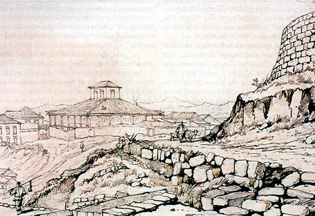 Macao residences, as seen from Bom Jesus. George Chinnery. 1836. Col. Toyo Bunko.
The São Tiago da Barra Fortress was built on the site where, in 1622, there was already a battery of cannon; it was completed in 1629. It was the first governor of the territory, D. Fransisco de Mascarenhas, who ordered its construction, along with various other city fortifications, under the supervision of a Spanish fortifications expert called D. Fernando de Morales. It was situated at the south of the peninsula, on the western coast; linked to the wall that ran from the Bomparto Fortress to the Inner Harbour, it was designed to protect the Inner Harbour and control shipping access. Within its walls there were lodgings for the commander and his staff, supply stores and barracks, which gave it the appearance of a real village. Later, a chapel was also built there, dedicated to São Tiago. The construction of the Barra coast road cut away almost two thirds of its area, next to the sea.
Among the fortifications built at that time was the São Pedro Fort, situated on what was then the mid-point of the Praia Grande Bay, where the monument to Jorge Álvares is today. Built after 1622, it was linked to the Nossa Senhora do Bomparto Fortress and the São Francisco Fortress by a low wall. Its purpose was to defend the coast of the Outer Harbour. To begin with, it had a triangular plan, which was later extended and reinforced. It was built of stone blocks weighing four to five tons each. Its sloping walls were supported by stone foundations built into and onto the existing rocks.
At the same time the São Jerónimo Fort was built, on top of the small hill overhanging the São Francisco Fortress, from where it could bolster the defensive power of the latter and also support land operations. It was formed by two triangular platforms where the cannon were ranged. At this point the wall running from the Monte made a right-angle turn towards south-west, to the São Francisco Fortress.
In 1622, there was also an ancient battery at the base of São Jerónimo Hill. Here, in 1629, the São Francisco Fortress was built, integrated into the line of fortifications surrounding the city's existing residential nucleus, which joined it to the São Paulo do Monte Fortress, as well as the São João Bulwark and the São Jerónimo Fort. Next to the fortress was the São Francisco Convent with its church. This fortification constituted the first line of defence against sea attacks and its artillery fire could reach Ponta da Cabrita, on Taipa, covering all the space between the two coasts. Given that its walls followed the contours of the hill on which it was built, it had an irregular plan, with two towers to the east and west. Within its confines were lodgings for the commander and his staff, munitions depots, and a church.
On the highest point of the peninsula, at an altitude of 94 meters, the Nossa Senhora de Guia Fortress was built between 1637 and 1638, outside the defensive walls of the city. It acted as an ancillary battery and also as a lookout post for approaching ships or typhoons. It was built as a defence against China, and its artillery covered the whole peninsula. It had a rather irregular shape because of the site conditions. It housed a barracks and a water reservoir, and within its enclosure was a chapel, constructed some time before 1622 and dedicated to Nossa Senhora de Guia (Our Lady of Guia).
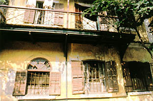 Typical windows and verandas of traditional Macanese architecture. Photograph by Joaquim de Castro.
THE CRISIS
During the economic depression, there was practically no construction carried out in Macao. Public services were housed in existing buildings, sometimes abandoned by their former owners who had left in search of a better life. An Imperial decree of 1730 authorised the inhabitants of the tancas (Macanese houseboats) to build houses along the riverbanks, which they had previously been forbidden to do, since they were not natives of China. Thus new residences appeared along the Inner Harbour, which were originally palafittes and later houses similar to those of the local inhabitants.
In spite of the prohibition on construction, some temples were built during this century, undoubtedly in order to implore the Heavens to assist the city in its time of crisis. During the reign of Ch'ien-lung, at a date sometime between 1736 and 1796, the Soi Ut Kun Miu, or T'ou Tei Miu, the "Local Gods Temple", was built on the slope of Patane Hill, close to the Camões Grotto. In 1730, to the west of the present São Domingos Market, the Kuan Tai Ku Miu was built, which was the headquarters of the "Three Roads Association", the oldest Chinese charity organisation in Macao. Around 1789 the Lin K'ai Miu, or "Lotus Brook Temple" was built, close to the Patane stream. This brick temple with its stone pillars is ornamented with multi-coloured bas-relief friezes on the upper part of the walls, and has a piece of gilded wood with figures in high-relief over the entrance. On the ridge of the gabled roof of green glazed tiles is a carved pinnacle which terminates at the gables in ledges on which stand lions, the guardians of the temple.
Meanwhile, the Portuguese only built a chapel within the São Tiago da Barra Fortress, in 1740, and, between 1748 and 1758, the São José Church to complement the already existing seminary.
In the early decades of the 19th century, construction was still limited to works of conservation or alteration of existing buildings. The churches of São Lourenço (in 1801) and Santo Agostinho (in 1814) were rebuilt, as was the convent of Santa Clara in 1824. Non-Catholic cemeteries were established: the Protestant Cemetery in 1821, the Parsee Cemetery in 1829 and the Chinese Cemetery in 1849.
STYLES
Macao was always a diverse city, incorporating Chinese and Portuguese in a cosmopolitan community. Despite its limited resources, it still managed to survive, even through difficult times. Its specific character, developed in the 16th and 17th centuries, bequeathed to us a splendid architectural heritage of its glorious past, a living testament of cultural intermingling throughout the centuries.
The initial Chinese style of architecture that existed at the time of the Portuguese arrival in Macao, which predominated throughout the next few decades, was followed by a period in which the Portuguese style was clearly dominant, with small mutual influences. These influences arose from the different ways of life and were unevenly applied to the various aspects of architecture - building plans, construction methods, finishings, decoration, etc. The Portuguese way of building, itself the result of diverse influences, came into contact with the building methods of the local labour force, whereby indigenous elements were introduced.
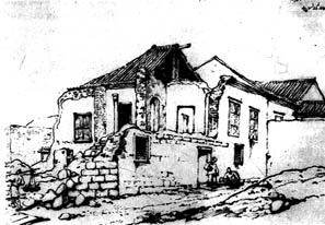
House in ruins. Macao. George Chinnery. 1840. Col. British Museum.
The houses existing at that time were described by a Chinese contemporary writer with some truth, but also with a certain degree of exaggeration: "The houses have several floors. Some have three floors and are built into the hillsides either at the top or the base, with some being square, others circular, triangular, hexagonal, or octagonal, similar to the forms of flowers and fruit. The roofs look like snail shells. These houses compete with each other in beauty. The walls are made of bricks or earth with a thickness of four or five covados [an ancient measure - one covado = 0.66 meters] and open windows all around. The houses are whitewashed and the windows are the size of doors. Inside, there are doors with pairs of door knockers. On the outside, the small windows are sealed with mica. The doors of the upper floors are all open at the sides with stairs of more than a dozen steps, and entry to the interior is from the rear. The masters live on the upper floors and the slaves on the lower floor."
Throughout the city's natural organic growth process, little by little a unique style - hybrid in character and conducive to eclecticism - was developing, and this style held sway for many years. There was a total fusion of the special characteristics of the two cultures, Chinese and western. The resulting new style, which was harmonious and pleasing, therefore had a little of the Chinese and a little of the European and was adapted to the particular characteristics of Macao -climate, available material, labour, and scarcity of space for building which necessitated the use of several floors.
With the exception of a few vestiges, namely in churches, one cannot speak of "colonial architecture" in Macao, since its characteristics, which are so widespread in Africa or Brazil, are not found here.
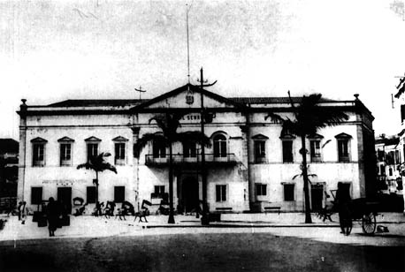
Largo do Senado. Approx. 1927. Photo col. of João Loureiro.
This Sino-Portuguese hybridism is mainly reflected in the buildings designed as residences, where a great concern for aesthetics is evident. The Chinese temples maintained their own characteristics, without western influences, while, in turn, the buildings meant for public services showed hardly any influence from Chinese architecture. This means that the fusion did not prevent each of the two styles from being kept relatively pure, existing alongside the new creations.
Today there are still some rare examples of architecture of this time - the few that were not demolished by less enlightened spirits who were not concerned with preserving the essential elements of the heritage of a people.
Neo-classicism in architecture, which was dominant in western countries during the 19th century and spread to some extent throughout the whole world, had a decisive influence on architecture in Macao.
The principles guiding construction in the city relied on different styles with their roots in classical architecture, to which they added new forms and ideas. Exotic details derived from the modern western architecture of the colonies was combined with a style which we can call neo-Chinese, along with other western influences and details based upon classical revivalism. Buildings erected in Macao from the beginning of the 19th century were subject to all of these influences.
The residences of the most influential families of Macao, stretching along the Praia Grande and scaling the slopes above the bay, were the main repositories of this amalgamation. But throughout the whole city, along the roads or in gardens large or small, houses were built in the new style, but with traditional materials such as walls and columns of brick, covered with a Chinese roof and painted with whitewash made from oyster shells. The windows had hinged louvered blinds and mother of pearl fanlights.
The Chinese houses maintained, in a simplified form, the ancestral house plan: a double entrance, sometimes triple, a main vestibule with the doors to the rooms around it, a secondary entrance generally linked to the service courtyards and a large central courtyard surrounded by columns - the heart of the house.
In order to implement new principles without demolishing existing buildings, false façades were often attached to the most important of these. The Santa Casa de Misericórdia was embellished with a two-storey arcade, with buildings in the Largo de Senado, the Praia Grande and the Inner Harbour following suit. Soon the new buildings would be designed from scratch, with arcades and verandas which formed continuous passages for pedestrians - a useful idea allowing people to walk about protected from rain and intense heat.
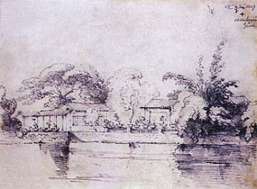
Macao residence. George Chinnery. 1827. Col. Toyo Bunko.
The Santa Sancha mansion was built in 1846 as the residence of the then Baron of Cercal, later being used as a rest home for the priests of foreign missions from Paris, as the headquarters of an English commercial company, as a women's and maternity hospital, with special services for children, and, finally, from 1926, as the Governor's Residence. Built in the neo-classical style of its time, the middle of the façade is indented to accommodate a portico covered by a veranda with balustrade. A circular arched gable surmounts this recess.
The Macanese José Agostinho Tomás d'Aquino, who studied "mathematics, design and commerce" in Lisbon, had a vast repertoire of building, reconstruction and modification designs, all in the eighteenth-century style, inspired by academicist neo-classicism: the construction of the Teatro Luso-Britânico (Luso-British Theatre), in 1839; and the reconstruction of the São Lourenço Church and the Cathedral, between 1844 and 1850. He adapted the São Domingos Convent into a military hospital in 1848. The following year he built the palace of the then Visconde do Cercal (currently the Governor's Palace) and, in 1850, the house of the new Baron do Cercal. In 1851 the São Francisco Convent was demolished to build a barracks of his design. He was, without doubt, the first Macanese architect.
Given the poverty of the Government premises and the Governor's residence, which consisted of rented houses or temporary accommodations, devoid of the grandeur appropriate to their use, in 1851 Governor Isidoro Francisco Guimarães, Visconde da Praia Grande, ordered a palace to be built in the Avenida da Praia Grande, in front of the São Pedro Fort. It was a spacious two-storey building and various services were installed there. In 1872, in keeping with current taste, an arched peristyle was added to the centre, with a veranda above. The veranda had a balustrade and columns supporting the canopy, which also had a balustrade and mouldings. At the same time a single-storey guard house was built next to the palace, with its façade protected by a colonnade. In 1884, Government headquarters moved to the Visconde do Cercal's palace and only public services remained in this building, until it was demolished to make way for the present Government Bureaux buildings.
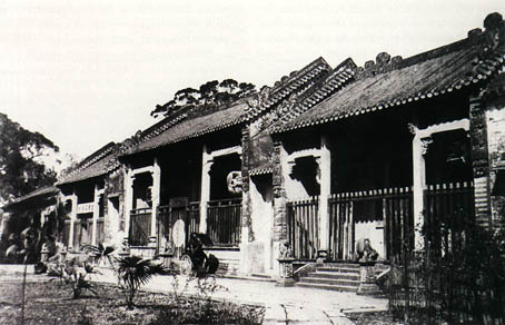
Lin Fong Miu. Approx 1930. Photo. col. of João Loureiro.
In 1849, Governor Ferreira do Amaral ordered Mong Há Hill to be fortified as a forward defence of the peninsula. Work stopped because of his assassination, only being taken up again some years later, and the fort was completed in 1866. It has a rectangular layout and possesses a munitions depot. Meanwhile, in 1852, the D. Maria Ⅱ Fort was constructed on the hill of the same name in order to provide reinforcement and covering fire for the Mong Há Fort. It has a hexagonal layout and had a drawbridge, and a cesspit next to the south-east wall. Both of these forts were built in the style of those previously erected in Macao.
The first lighthouse on the Asiatic coast of the Pacific was inaugurated in 1856 on Guia Hill, built on the orders of Governor Coelho do Amaral. It is octagonal in shape and 13.5 meters high. Initially functioning with a kerosene lamp, it has had modem rotating equipment since 1910.
Some years later, another illustrious designer, the Baron do Cercal, came to add his contribution to Macanese architecture. His designs, in the neo-Gothic style, are evident in various buildings of the city. One of his most expressive works was the facade added to the D. Pedro V Theatre in 1872, built by Pedro Germano Marques two decades earlier in a mixture of Portuguese architecture and Greek and Roman classical influences. Another of his important works was the São Januário Hospital on the summit of the hill of the same name. After excavation, levelling and consolidation of the land, a building suitable to its purpose and following the most advanced principles of the time was constructed and completed in 1872. It had a rectangular layout of around 75 meters by 34 meters, subdivided into five two-storey buildings separated by landscaped courtyards. As well as accommodations for administrative purposes, it had various specialised wards, rooms for the doctors and chaplain, a chapel, and various service facilities. It was built in the neo-classical style with Arabic influences - and the local labour force added its own stamp.
The Military Club, then known as the Grémio Militar (Military Society), was founded in 1870 and soon had its own private premises, also designed by the Baron do Cercal, facing the sea next to the São Francisco Garden. The single-storey building has the style imposed by its creator - its neoclassical lines displayed in columns and pilasters supporting the top balustrade and the circular arched pediment, with moulded bays opening onto wide verandas.
The Italian architect Cassuto designed the Quartel dos Mouros (Moorish Barracks) which was completed in 1874, employing a style which, rather than neo-Arab, can be termed "Neo-Indian" because of the influences derived from English architecture in India which characterise it. It is located on the north-west slope of Barra Hill with its large main facade turned towards the Inner Harbour. According to contemporary testimonies, the barracks had vast and well-ventilated bunk rooms where "two hundred soldiers were accommodated," rooms for officers, and a large room looking onto "the terrace which runs right round the building, and from which an admirable view can be enjoyed."
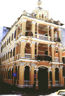
Typical "false façade" building of neo-classical influence (1918). The building housed a Chinese school for many years and is currently a Youth Centre.
The small Senate building, built in 1583 and described, in around 1751, in the Ou Mun Kei Leok as a single storey building with a porch inside a walled area, was later replaced by a new building. The work, which was carried out in 1784 according to the design of Father Patrício de São José, was described in the following words: "The public building in which the Government holds its sessions, called by the name of Casa do Senado (Senate House), has two storeys. The base is of granite and the remainder of lime and brick, including the pillars (...) The entablature is supported on columns and the cornice is ornamented with glazed porcelain vases (...) In the auditorium is the Nossa Senhora de Conceição Chapel (...)" The terrible typhoon of 1874 caused grave damage to the building. The rebuilding work, completed two years later, paid special attention to the main façade, which was remodelled to suit current tastes. The main door and three central windows of the first floor which opened onto a railed veranda were surmounted by perfect arches, while the remaining windows were squared and surmounted by small pediments.
The Nossa Senhora de Esperança Church was also totally rebuilt in 1885 to replace the old church from the 16th century. It has a lateral bell tower and its nave terminates in rounded arches. The façade with back-to-back pilasters is finished with a curved pediment: once again classicism is adapted to the current taste.
In the same district of São Lázaro some residential buildings from the end of the century can still be found, for example, the group close to the church constituting two semi-detached houses and one other, a triangular-shaped corner house. Although of very simple design, they nevertheless attest to the interest there was then in domestic building. In front of the church is a building of neo-classical lines which, along with those just mentioned, is considered to be "worthy of preservation".
Other turn-of-the-century buildings which were initially designed for housing and built in the same amalgam of styles can be found here and there throughout the city, from the Portas do Cerco to the Largo do Senado, in Barra or the Largo da Sé, in the Rua dos Mercadores, Rua de São Lourenço, Rua de São Paulo, Beco do Lilau, and along the new street grids.
Non-residential buildings are still a testament to the architecture of the period, their imposing towers conspicuous for their proportions and particular characteristics. Also of note are the Hotel de Cantão in the Rua do Guimarães, the Pavilion of the Lou Lim Ieoc Garden, etc.
In 1900, the Hotel Boa Vista was opened, in a building which was already around twenty years old. All the traces of local neo-classicism are evident in this three-storey building - the arcades, the columns, the balustrades, the rounded arches, the mouldings, and even a small pediment. Its luxurious interior helped to make the hotel internationally famous.
The Chinese temples still maintained their ancestral characteristics. In this period, the Lou Pan Si Fu Miu, the T'in Hau Miu, the Choc Lam Chi, the Chong Kuok Tou Tei Miu, the Pao Kong Miu, and the Na Ch'a Miu were built, along with, at the end of the century, the charitable institution Tong Sin Tong.
With regard to military fortifications, it can be said that demolition work was greater than construction in this period. The existence of city walls was no longer justified, and little by little they were pulled down along with the secondary defence posts which formed part of them. Only the Bateria 1° de Dezembro was built, in 1872, next to and below the São Francisco Fortress, constructed to defend access to the Praia Grande, but serving mainly to shelter vessels in times of storm. It had a circular layout with five platforms for artillery pieces, and its walls were steeply inclined as a means of defence. It had lodgings for the garrison, munitions depots and various warehouses, and was connected to the São Francisco Fortress via an underground passage.
THE 20TH CENTURY
The era of cement had arrived. The first buildings constructed in reinforced concrete still attempted to follow classical lines, with stylisation derived from the characteristics of the new material. As building styles became more and more simplified, vestiges of the Macanese style eventually became diluted and then substituted by more or less rectilinear shapes.
In the first half of the century, architect-free architecture proliferated. Buildings of small dimensions - two, three, or four floors - filled the city. They contained modest residences, but sometimes tried to simulate the façades of older and more imposing buildings, with complicated verandas and a profusion of curved lines in architectural detail. The ground floor was normally given over to commerce. Designs produced by anyone capable of getting his hands on a pencil and a ruler began to be presented to the Public Works Department - and they were approved. At times they only consisted of an "embellishment" to the façade, which more often than not produced a result that was worse than before...
The plan of the Avenida Horta e Costa, in 1901, provided the opportunity for serried rows of residential buildings, not conforming to any particular style, to spring up, and they quickly spread out along the rest of the new roads, from the Avenida Conselheiro Ferreira de Almeida to the Avenida Almirante Lacerda. Initially having one or two floors, little by little they grew, in an irregular fashion, and are being replaced today, also in an irregular fashion, by buildings of 30 to 40 storeys, interspersed with a few "dwarves" of seven storeys.
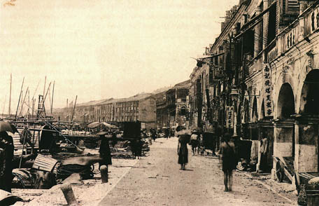
Architecture along the Inner Harbour waterfront. Macao 1903. In "Um Marinheiro em Macau - 1903 - Álbum de Viagens" (A Sailor in Macao - 1903 - An Album of Travels) (Ed. Macao Maritime Museum).
The opening of the Avenida Almeida Ribeiro, which was completed in 1918, following the expropriation and demolition of the old buildings blocking its path, gave rise to a wave of new projects employing reinforced concrete and the systematic use of arcades. The "Urban Intervention Plan for the Avenida Almeida Ribeiro," drawn up in 1983 by Palmer & Turner, contains specifications to control construction in the area, in order to promote urban renewal in the field of preservation of classified buildings and environments. Four kinds of intervention are considered: construction projects on any free sites or on demolition sites; reconstruction projects for derelict buildings, which restore their original features; conversion projects, which maintain the essential elements of the existing building, but improve it; and restoration projects, which maintain the existing structural conditions. In all cases the building height and width, frontages, distances for volumes to be set back from the regulation line, and number of storeys, along with the existence and dimensions of arcades, are set out. This regulation was revised and detailed in 1984, specifying on a case by case basis the operations to be carried out.
Certain dignified buildings deserve a mention, such as the Casa Branca, home of the Precioso Sangue Convent, designed by John Lemn and built in 1916; a house in the Rua do Campo by J. Caer Clark, built in the same year; or the Vista Alegre by Jose Fransico da Silva from 1917/18, which is currently the Leng Nam School - some of the very few works by architects in this period.
The Art Deco style which developed in Europe between the 20's and 30's soon reached Macao, where it was applied to houses, such as the Skyline, to religious colleges, such as the Salesian, or even to public buildings, such as the Mercado Vermelho, built in 1934 to the design by Júlio Alberto Basto.
Modernism, a purified form of the earlier style, reached Macao in the 30's and 40's. Its horizontal geometry, with smooth and practically ornament-free surfaces, was employed, for example, in the Pedro Nolasco da Silva Primary School and in the Sir Robert Ho Tung Luso-Chinese School. One of its proponents was João Canavarro Nolasco, who worked in Macao from 1936 to 1950.
Following the relative stagnation during the years of the Second World War, whose repercussions were felt in Macao, the city was once again re-born. In the middle of the century there was an increase in population due to the immigration of Chinese peasants and fishermen. In conjunction with this demographic growth, there was an explosion of economic development, and, as a result of both factors, there was a new phase of urban expansion in the territory. The few empty spaces still existing were filled, and low level buildings were demolished to make way for tall ones, without any master plan.
Some improvements were implemented in this period, in the realm of facilities and infrastructures, especially the city water supply, begun in 1936. The "chácaras" (rustic properties) of Penha and Barra were replaced by houses of the well-to-do, while the poor became concentrated around the Inner Harbour, next to Ilha Verde. For the refugees, a new district was constructed near the racetrack.
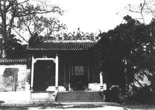
Kun Iam Temple. Approx 1930. Photo. col. João Loureiro.
From 1950 onwards, Portuguese architects began to "discover" Macao. Whether sent on official business by the Ministry for Overseas Territories or arriving as "tourists" (who left almost as soon as they arrived), little by little they began to establish themselves here, out of a love for the city and an awareness of its possibilities. Although they were initially not well accepted, since anybody could draw up an "outline," they eventually made their mark, giving rise to a body of architects' architecture. Technicians from China or Hong Kong then came to swell these ranks, which included various Macanese architects.
In the transition phase between the two periods, there were still buildings (considered modern in the 1960's) which were built for residential purposes, with six and seven floors (and no lift); and their paradigm continued to be promoted, forcing the hand of architects and designers - using every square centimetre of space, these homes overlooked only a tiny courtyard, and had bars on the windows and verandas for fear of cat burglars (who were said to scale up to the top floors using the smallest projections in the façade).
Some significant buildings were also built in this period, such as the Mercado de São Domingos, in 1950, the "das Repartições" building in 1951, and the São Januário Hospital and the Liceu Infante Dom Henrique (school) in the 1960's. The Hotel Lisboa was built in 1970 according to the design by Liang Tat Man.
Meanwhile, Chorão Ramalho set up a school, working with a group of young architects who would later continue to design either alone or in partnerships. The projects for the Pedro Nolasco School, the Avé Maria Nursery School and the "towers" to house civil servants are all his.
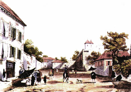
Macao street scene, probably the Rua de S. Lourenço. Coloured lithograph by C. Graham in his "Sketches in China". London, 1840. Derwent Collection. In "An American in Canton (1824 - 44)". William Hunter. Derwent Communications Ltd. HK, 1994.
The Instituto Cultural de Macao, formed in 1982, aims to preserve the Portuguese cultural presence in the territory in several aspects. One of its purposes is to protect architectural heritage, seeking to conserve and restore it. For this purpose it drew up a list of buildings, environmental areas and protected areas to be maintained, considering them to be an important legacy for future generations. It was on the initiative of this Institute that the legislation in force since 1976 was revised and new measures prescribed to achieve the proposed aims. A legislative diploma approved in 1983 outlines the monuments, complexes and sites to be preserved and proposes a law encouraging the practical application of these measures, including tax incentives and the exchange of classified buildings for empty sites suitable for building. For some buildings, these measures did not arrive in time; the mirage of profit had already caused them to disappear, replaced by large constructions. But others are now being saved and adapted to diverse ends, such as museums, libraries and public service buildings.
In 1986, a Macao government initiative proposed that the historical centre of Macao be included in the UNESCO list for world-wide preservation of historic sites. This study was prepared by Partex under the supervision of Tomás Taveira, taking into consideration the territory's existing legislation on the preservation of building heritage.
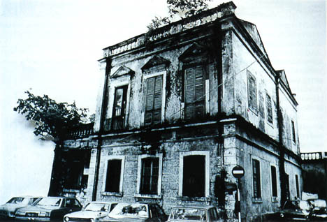
Old house of the "neo-Pombaline" style, which was very popular in Macao at the beginning of the last century. In this house, since destroyed, lived Harriet Low, Cultural Institute archive.
For the purposes of this work, the city was divided by urban and architectural characteristics into the following areas, which represent the stages of development throughout its history and still maintain their distinctiveness:

Inner Harbour
Praia Grande
Barra and Penha
Avenida Cons. Ferreira de Almeida/
Rua Ferreira do Amaral
Mong Há and Avenida Horta e Costa/
Avenida Coronel Mesquita
In this study, the historic centre was considered to be the most important area, having the greatest historical, monumental and cultural significance and with the original characteristics of its architecture generally intact. It corresponds to the old walled city which lasted until the second quarter of the 19th century and was distinct from the Chinese areas which were situated outside the walls. The main source of interest in the Inner Harbour, which was regulated at the beginning of the 19th century, were its street-level arcades with verandas above, which have now become conditions for reconstruction work in the area.
Building in the Praia Grande dates, effectively, from the 18th century. It is here that the major foreign commercial companies headquarters could be found, along with imposing houses and public buildings with special characteristics which should be preserved. In Barra and Penha, there were originally "chácaras" (rustic properties). These were progressively replaced by structures along the streets; however, a reasonable green area still exists even today. The remaining areas belong to the 20th century and have their own distinct characteristics, different from those of the older areas.
With the recent building "explosion" in Macao, new buildings have appeared in all these areas, forcibly changing their character, even in the cases where building permission depends upon maintaining the existing façades. Progress is unremitting and conservationist sentimentality is losing ground; the dream that gave rise to the Partex proposal is about to die out. Only a few isolated buildings remain, themselves partially remodelled or else abandoned and beyond repair. But if the historic city can no longer be preserved as a whole, the actions of the Instituto Cultural de Macau may save that which remains.
Since the second half of the 1970's many architects have settled in Macao, and it has become obligatory for all new projects to be approved by an architect. It would be difficult to detail all the work carried out since then. Some of them are very good, and some less so, but they have all contributed to make Macao the city of today, the city of tomorrow.
Below is a list of the recent works of the architects who work in a private capacity in the territory:
Project - House in Penha
ADALBERTO TENREIRO
Born in S. Tomé in 1955
Graduated from ESBAL (Graduate School of Fine Arts) in 1980
Based in Macao since 1983
Project - Restaurant building in Taipa
Project - Residential building with 23 storeysin Rua Silva Mendes - 1989/90
ANA BORGES
Born in Angola in 1956
Graduated from ESBAL in 1980
Based in Macao since 1982
Project - Naval pilot school in the Inner Harbour - 1979/89
ANTÓNIO BRUNO SOARES
Born in Lisbon in 1947
Graduated from ESBAL in 1973
Based in Macao since 1978
Project - Maritime Museum in the Inner Harbour
Project - Housing Scheme in Mong Há
CARLOS BONINA MORENO
Born in Covilhã in 1945
Graduated from ESBAL in 1979
Based in Macao since 1982
Project - Office building in the Rua da Praia Grande/Rua do Padre Narciso-1990/91
CHAN CA TONG
Born in Macao in 1959
Graduated from ESBAL
Based in Macao since 1986
Project - Residential building
EDDIE WONG
Born in Macao in 1952
Graduated from the University of Texas (Austin)
Based in Macao since 1979
Project - Casa da Guarda do Centro de Instrução Conjunta, in Coloane - a 1985 project, completed in 1990
EDUARDO FLORES
Born in Luanda in 1954
Graduated from ESBAL in 1981
Based in Macao since 1982
Project - House in Coloane
Project - Public Housing Block 1 of C. T. T., Avenida Almirante Lacerda/Avenida Ouvidor Arriaga -1991
EDUARDO LIMA SOARES
Born in Lisbon in 1945
Graduated from ESBAL in 1971
Based in Macao since 1977
Project - Finance Department Building (in collaboration with António Bruno Soares), Rua da Praia Grande/Rua da Sé - 1987
IRENE Ó
Born in Macao in 1947
Graduated from ESBAL in 1973
Based in Macao since 1978
Project - Office Buildings, Avenida da Amizade
Project - Hotel, Taipa
JOSE PEREIRA CHAN
Born in Macao in 1941
Graduated from ESBAL in 1967
Based in Macao since 1969
Project - Restoration of two houses for Public Services Facilities, Rua Sanches de Miranda - 1990
LUÍS SÁ MACHADO
Born in Escalhão in 1951
Graduated from ESBAL in 1980
Based in Macao since 1983
Project - Residential building in the Praia Grande
MANUEL VICENTE
Born in Lisbon in 1934
Graduated from ESBAL in 1962
Masters in Architecture from the University of Pennsylvania (U. S. A) in 1969
Based in Macao since 1962
Project - Public Administration Training Centre, Estrada D. Maria Ⅱ, Edifício CEM - 1989
Interior design- 7th and 8th floors
Project - Residential building, Avenida Almirante Lacerda.
MARIA DA CONCEIÇÃO PERRY
Born in 1954
Graduated from ESBAL in 1980
Based in Macao since 1983
Project- Day Care Centre/Health Centre/Youth Centre, Rua Constantino Brito
PAULO SANMARFUL
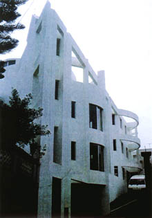
House in Penha, facade.
Born in Carcavelos in 1950
Graduated from ESBAL in 1977
Based in Macao since 1979
Project - Macao Electric Company, Estrada da Bela Vista
VICENTE BRAVO FERREIRA
Born in Angola in 1946
Graduated from ESBAL in 1974
Based in Macao since 1981
TEACHING
ESTABLISHMENTS
As we have mentioned at various points in this article, for many years education in Macao was the domain of the religious orders, especially the Jesuits, who founded the first school in 1572, next to the Santo António Chapel. From this school developed the S. Paulo college, created in 1594, which eventually became the first University of Macao. In the same complex there was also a Japanese seminary and also, for some years, a school of painting. The whole educational and religious complex of S. Paulo was destroyed by fire in 1835.
Other schools also existed, namely in the St° Agostinho Convent and the São Domingos Convent, which taught "reading, writing and Latin", and sometimes art or music.
Because of the Marquês de Pombal's decision to expel the Jesuits, teaching in Macao suffered greatly. To compensate for this loss, Lisbon sent a regius teacher starting in 1784, and other classes were given by secular priests. In 1834 the various religious orders had disappeared, which aggravated the situation. At that point, lessons were only given in the São José Seminary and the so-called "Charity Schools" which were run by laymen in their own homes.
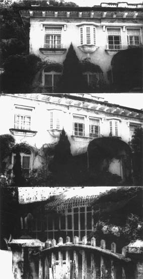
Hotel Caravela.
The Escola de Primeiras Letras (primary school) that existed in 1797 was succeeded by the Escola Principal de Instrução Pública (Main School for Public Instruction) in 1847. From this was derived the Escola Primária Oficial (Official Primary School), which opened in 1872 with two sections, for boys and girls, in two separate buildings. In 1862 the Nova Escola Macaense (New Macanese School) was created by private initiative.
The Recolhimento da Sta Casa da Misericórdia (charitable asylum) for "orphaned daughters of the Portuguese" was built in 1718. It only began to function eight years later, teaching "the arts a woman requires to administer her house." This establishment was substituted in 1792 by the "Asylum or House of Education for girl orphans", which later took the name of "Recolhimento de Sta Rosa de Lima." It was temporarily housed in the "Casa das 16 Colunas," which nowadays is the Salesian Institute, and then in the St° Agostinho Convent and the Monastery of Sta Clara, the latter having been incorporated into the Sta Rosa de Lima college in 1875.
The Pio Ⅻ, which functioned from 1951 to 1972, and the Stella Matutina College, which was founded in 1953 and ran until 1975, also now form part of the Sta Rosa de Lima College, in its various buildings.
In order to combat the problems arising from the lack of schools, the Associação Promotora da Instrução dos Macaenses (Association to Promote Macanese Education) (APIM) was founded in 1871, with the creation of a commercial school in 1878 being one of its initiatives. This school, "Pedro Nolasco," only got its own building in 1920, in the Calçada do Gamboa, from whence it moved to its present building on the Avenida D. João Ⅳ, designed by architect Chorão Ramalho and opened in 1966.
Meanwhile, in 1728 the S. José Seminary began to function in its own building. We believe this to be the oldest building in the city which has been kept in a practically unaltered state and in relatively good condition, although it is for all intents and purposes abandoned, only being used as a residence for a few priests.
From time to time there have been navigation schools in Macao, the first one being a private initiative, between 1786 and 1801. This was followed by the Escola Real de Pilotos (Royal School of Navigation), from 1814 to 1822. A decree in 1862 created a Chair of Nautical Science in the seminary. A new decree, in 1905, created another school of navigation which ran until the time of the World War. There was also a short-lived artillery school; created in 1820, and, briefly, a Military Academy or "Mathematics Class", founded in 1835. A new School of Navigation was recently inaugurated in the Inner Harbour.
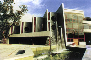
Maritime Museum - Carlos Bonina Moreno.
In 1859 the Sisters of St Paul of Chartres settled in Macao, fleeing from Hong Kong with the children under their care. They founded a school where they taught French, English, Portuguese and liberal arts, from which developed the College of the Immaculate Conception, inaugurated in 1864 and, after a brief closure, reopened in 1872, at which point it continued to function until 1894. After the Second World War, the Order returned to the city, this time to their own house, the Casa de São José where there was a nursery school and a school for girls from Hong Kong until they again left in 1967, offering the premises to the diocese of Macao.
The Canossian Sisters (members of the Italian religious order of The Canossian Daughters of Charity) arrived in Macao in 1873, opening a Chinese school for poor children, close to the Monte Fortress. In 1885 the Sta Infância Asylum for abandoned children was built, which was later demolished to make way for the Escola Canossa (Canossian School). Various branches of this school were subsequently opened in the city and on the islands, providing education to Portuguese girls until 1974. The Pui Cheng School was established in the Casa de Beneficência das Canossianas (Canossian Charitiable Institution), later extending into a new building on the site of the old Sta Infância Asylum, where it became the Escola Canossa. In 1959, another free school for the children of the Patane District opened in the Casa de Beneficência.
For some years, between 1889 and 1903, the Canossian Sisters ran the Santa Rosa de Lima College, who then handed it over to the Franciscan Missionaries of Mary, who had just arrived in Macao and installed themselves in the Sta Clara Convent, which has since disappeared.
The Canossian Sisters then set up the Perserverança College, based in the Casa das 16 Colunas, staying there for seven years and then moving to the Casa de Beneficência, which closed in 1910. Re-opened at a later date, the Casa temporarily housed the Colégio do Sagrado Coração (Sacred Heart College), in 1938, which, in the same year, moved to its own building on the Estrada Coelho do Amaral. It currently occupies the whole block delimited by that road, the Avenida Ouvidor Arriaga, the Rua Padre João Clímaco and the Avenida Coronel Mesquita.
The Canossians also opened a school in Mong Há in 1907 on the site of the present S. Francisco Xavier Asylum (inaugurated in 1973). At present, they run four teaching establishments, encompassing pre-school to secondary education.
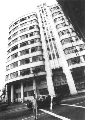
The Grand Hotel.
The Macao Liceu was created by a decree of 1893, initially being situated in the St° Agostinho Convent and then moving to the Calçada do Governador in 1900. It moved successively to the Boa Vista Hotel (1923); Tap Seac (where the Invalid Asylum had been), from 1924 to 1958; its own building on the Avenida Infante D. Henrique; and, finally, the School Complex designed by Tomás Taveira which was inaugurated in 1986. This Complex includes the Infante D. Henrique Secondary School, the Dr. José Gomes da Silva Preparatory School and the Luís Gonzaga Gomes Luso-Chinese School.
The Salesians had arrived in the territory in 1906 and formed, in the same year, the Orfanato (Orphanage) da Imaculada Conceição, which moved from its original premises in the Rua da Prata to the Casa das 16 Colunas, and evolved into the Instituto Salesiano da Imaculada Conceição (the Salesian Institute). This building no longer boasted its eponymous columns, but the name stuck from the era of the original private residence on the site, which became successively the Governor's Residence, the offices of the British East India Company, and various schools.
During the Second World War the São Luís Gonzaga College was established in Macao. It was begun in 1943 in a building in the Rua de São Lourenço, later moving to the Praia Grande. It was primarily intended for Hong Kong refugees, who returned to their home-town after the war, and the college closed in 1945.
In 1955 the Ricci College was founded by Jesuit missionary refugees from China. They settled in the Rua da Praia do Bomparto in the so-called "Casa Ricci", where only the primary school remains today. They later built new premises in the Rua do Chunambeiro, which was inaugurated in 1959 and extended in 1962. The Secondary School operated in the Travessa do Colégio, in a building dating from 1962.
The Instituto D. Melchior Carneiro was created in 1961 and includes a day-care center, pre-school, primary and secondary schools and a commercial section. The institute started life in a small rented building, and nowadays owns various buildings on the Travessa de São Paulo, close to the Monte Fortress.
The Jesuits returned to the territory in the middle of this century and resumed their teaching activities. The São José Diocesan College was founded in 1931 in a building in the Rua da Prata, later expanding to other parts of the city. In 1954 they opened a small school for poor children in the Rua das Estalagens, which moved to the Rua de São Paulo in 1966 and thence to purpose-built premises in the same road that opened in 1973 - the Santíssimo Rosário School.
The Estrela do Mar College opened in 1955 in the Rua do Padre António in houses belonging to the Diocese, and has since been expanded. The secondary school transferred to another building in the Rua da Prata, next to the Seminary, and has also expanded.
The Yuet Wah College opened in Macao in 1928, in the Estrada da Vitória, and was taken over by the Salesians in 1942. It currently operates a pre-school and primary school section in the Travessa dos Bombeiros.
Since 1975, the Salesians have run the Perpétuo Socorro College, with nursery, primary, secondary and commercial education.
In 1949, the first stone of the D. Bosco College was laid, designed by architect António Bastos. The college was inaugurated in 1951 and has been extended over the years.
A building for the São Paulo School, built to the design of architect Eduardo Tavares da Silva, was inaugurated in 1970 and also entrusted to the Salesians.
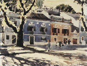
Macanese architecture of the 1940's.
Watercolour by George Smirnoff. Col. Macao Museum of Art.
There were also various nursing schools in Macao, the first of these being that of the Franciscan Missionaries of Mary, which began in the São Rafael Hospital in 1932, transferred to the São Januário Hospital and then the Sta Rosa de Lima College, and finally settled in its own premises in the Estrada dos Parses in 1967. The School of Nursing, Health Services and Hygiene was created by a ministerial order in 1957 and was located in the São Januário hospital. There is another nursing school in Kiang Wu Hospital.
Various other schools have had a temporary existence in the territory, such as the Escolas de Tipografia e Encadernação (Schools of Printing and Book-Binding, 1900-1920), the Escola do Expediente Sínico (Chinese Secretarial School, 1905 - 1968), the Escola Nova (New School, 1918 - 1919), the Escola Oficial de Taquigrafia (the Official School of Stenography, 1920 - 1923), the Escola do Magistério Primário (Primary Teacher Training School, 1965 - 1974), the Escola de Indústria Hoteleira (School of Hotel Management, 1975 - 1978). At present, the Nova Escola Hoteleira (New School of Hotel Management) is located in the Mong Há Boarding House.
It is not possible to describe here all the currently existing teaching establishments in the territory, as there are around eight dozen of them, and they will merely be mentioned later. However, I cannot fail to mention the University of Macao (ex-East Asia) on Taipa, which was designed by architect Jose Pereira Chan and inaugurated in 1981. Besides a Pre-University College, it also offers various higher education courses.
GREEN AREAS
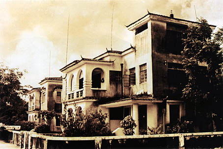
Villas on the Avenida Coronel Mesquita in the 1950's. Photo: archive of the Review of Culture.
There are still some... Yes, there remain a few green sites in Macao and on the islands, although increasingly fewer, as the kitchen gardens with their trees and shrubs have been eliminated and the landscaped borders along the roads have been cut back for road-widening. Once the mandarin law prohibiting new construction and the unauthorized felling of trees had fallen into disuse, this matter was only vaguely addressed in the General Regulations on Urban Construction, which, in Article 323 define the conditions for the authorisation of vertical occupation in new buildings, namely "that there is no prejudice to tree planting (...)". An empty phrase, in the majority of cases!
With the planting of the hills at the end of the 19th century, closely followed by tree-planting on the islands, reserves were created which, to some extent, still exist today, and which constitute the lungs of the city - Guia, Penha, the large gardens.
In the second half of the last century, a number of "chácaras" were built, a name which was given to the "country houses" of important families of the city. The majority of these rustic properties have now been urbanised, with only vestigial parks remaining.
The same thing happened to the hortas where the horticultural products that Macao then needed were cultivated (those products which now come frozen from all over the world). For health reasons, most of these market gardens disappeared at the end of the 19th century, and their properties were occupied by buildings. Those remaining soon suffered the same fate, a consequence of urban expansion.
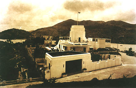
The Skyline Building. Photo from the 1950's. Archive of the Review of Culture.
However, to compensate for the successive losses, there are the gardens! The Vitória Garden and the Vasco da Gama Garden, which were once connected by a "promenade", both still display their monuments: to the victory over the Dutch in 1622 and to the Navigator of India (Vasco da Gama). The São Francisco Garden, nowadays at some distance from the sea it once overlooked, was laid out on terraces to the foot of Guia Hill. On the opposite side of the hill is the Flora Garden, where there is a small mansion which served temporarily as the summer residence of the Governor. Its vegetation (mainly trees and shrubs) is labelled, making it a small "botanical garden". Crossing Guia Hill is a mountain trail for fitness training among the trees.
Another "botanical garden" is the Camões Garden, the largest of the city. It unfolds on various levels to the "Gruta de Camões" (Camões' Grotto) where tradition has it that Luís de Camões wrote part of his major work. Originally created as a garden for the mansion of counsellor Manuel Pereira, it was laid out by gardeners from London, and cared for by a number of English botanists who gathered thousands of species of plants from China. They thereby created a nursery which provided plants for Europe at the beginning of the last century. Even today, valuable exotic species can be found there. The mansion was later acquired by the Macao Government and housed the Camões Museum. It is now the headquarters of the Orient Foundation.
But the jewel of Macanese gardens is, without doubt, that of Lou Lim Ieoc, formerly known as Lu Cau. It was created by Commander Lou Lim Ieoc, who built there a small mansion, pavilions, artificial grottos, and a lake with the "bridge of nine curves", all enveloped in astonishing vegetation, forming a typically Chinese garden. Only a quarter of the original area of this exuberant property remains, choked on all sides by the modem buildings surrounding it. The existing portion is the repository of its beauty, and well deserves to be preserved.
The Jardim da Montanha Russa (Roller Coaster Garden), in Mong Há, covers a small elevation which is reached by a spiralling road, hence the name of the garden. Amid the densely planted trees there is a restaurant and a small playground.
The main roads of the city are tree-lined, and small gardens burst out of diminutive spaces, at the corners of streets, in the central reservations of avenues or even under recently built viaducts. And on the building façades appear minuscule gardens, suspended from windows and verandas and supported by the iron railings protecting them.
THE ISLANDS
TAIPA
Although Taipa and Coloane are currently part of the territory of Macao, the history of the Portuguese presence on this islands is relatively recent.
The first references to Taipa date from the end of the 17th century, when the British ship Defence anchored there and its crew was badly received by the islanders.
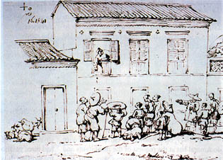
House in Macao, early 19th Century. George Chinnery.
Col. Macao Museum of Art.
Known locally as "Tam Tchai", meaning "small lake", it was formed of two islets separated by a thin stretch of sea - Taipa Grande (or Taipa Quebrada) and Taipa Pequena, which were later joined as a result of the natural silting process, aided by successive landfills. Taipa is situated to the south of the peninsula, at a distance of around three kilometres to its nearest point. It has two hills, 111 and 160 meters high respectively, which are the highest points in the islands. The village of Taipa grew up at the foot of the tallest promontory, in a valley surrounded by hills.
During the late 17th century, foreign ships headed for Canton via the Pearl River had to take on board a pilot and an interpreter in Macao, and were only authorised to continue after anchoring in Taipa. For this reason, Taipa was well-known to sailors - so much so that some sea maps referred to Macao as the "port of Taipa". If they were over 500 tonnes, they had to anchor there, and this rule was applied to all vessels after 1717. The small settlement beside the anchorage served as a trading post. Its inhabitants were mainly fishermen and river sailors, with a few farmers, poultry farmers and pig breeders, who were joined, from this date, by the first tradesmen who benefited from the existence of the anchorage. In 1845 the port of Taipa was declared a free port.
In 1847, on the orders of Governor Ferreira do Amaral but at the request of the inhabitants and funded by them, a small fortress was built as a defence against the pirates who were constantly attacking the island. It was built by the captain of the port of Macao, Pedro José da Silva Loureiro. It was located in the extreme west of the island and it controlled the sea traffic between Taipa and the island of D. João, and mainly served to defend the fishing port and village situated next to the adjoining bay. It was here, in the same year, that the Portuguese flag was unfurled on Taipa for the first time. It was once a coastal fortification, now distanced from the sea which once bathed it because of the siltation caused by the sediment carried by the Pearl River. On the sea side, a strong masonry wall shields the fortress. Behind, the wall merges into the slope of the neighbouring hill.
The fortress has its own well and also a munitions depot and accommodations for the soldiers. In 1872, restoration work was carried out on the fortress and the access road improved. At the same time, the quarters of the Chinese police in the village were also repaired. The main building was temporarily used as a summer residence for the Governor of Macao, and is now occupied by a police squadron. Its facade, with classical lines, was a later addition to the construction, and creates a porch along the fortified walls.
In 1851, a monument was erected close to the fortress in memory of the victims of the explosion of the D. Maria Ⅱ frigate, which had happened the previous year, killing around 240 crew members and native fisherman who were nearby. The monument is at the top of a stone staircase in the garden next to the Taipa tunnel.
The oldest temple in Taipa, Mou Tai Miu, or Kuan Tai Miu is dedicated to the god of war and was built in the reign of Hong Kei, which lasted from 1488 to 1505. It is a rather miserable, small black brick temple and is annexed to the T'in Hau Miu, which is connected to it internally and is in an abandoned state.
At the end of the 17th century, during the Ming dynasty, the Pak Tai Tin, or "palace of the sovereign god of the north," was built. It originally had three pavilions, of which only one is now used for worship. It is situated in the Largo de Camões.
Between 1840 and 1845 a temple dedicated to Tin Hau, "goddess of the sky," was founded in memory of the 200 sailors killed fighting pirates. It is the T'in Hau Un Kuan, or T'in Hau Ring, situated in the Largo Governador Tamagnini Barbosa, in front of the Town Hall of the islands. Of the three original pavilions, linked by courtyards, only the central one is still in use.
At the same time the Sam Pou Miu was built, which is now almost a ruin. It also had three halls, one of which still houses a bell bearing the date of 1844.
In the middle of the 19th century, the Kun Yam Ngam Miu was built at the foot of the Taipa Grande hill, on the peninsula side. It is situated on a lake 10 meters above sea level, delimited by a solid wall.
The most recent temple (and also the richest and best tended), P'ou Tai Un, was built in 1925 with a donation from an islander in memory of his mother, and is situated at the foot of the hill on Taipa Pequena, on the west side. The main sanctuary, Tai Hong P'ou T'in, is in front of the portico, and there are various pavilions throughout the courtyards for different purposes: for housing the ashes of ancestors, for the monks' reading and meditation, and for the chapels of Lok Wai Nam, the Three Precious Buddas, Pak Tai and Kun Yam.
The village of Taipa suffered from two large fires in 1853 and 1858, which spread easily through the buildings of wood and straw. In the wake of these fires, its inhabitants were freed from paying taxes for a determined period, as were the vessels transporting building materials for reconstruction.
Lighting was installed in the settlement in 1868. Between 1879 and 1882, the lighting contract was auctioned publicly every year, later coming under government control.
On the initiative of the local inhabitants, a narrow channel of sea between the temples of Tin Hau and Sam Pou was filled in. The work began in 1864 and was completed three years later, when shops were built on the site. Other small reclamation works were carried out over the years, filling in indentations in the coastline and providing new building space. Thus the natural coastline slowly began to disappear, and with the process of new urbanisation it was soon completely eliminated.
The Town Council for the islands was created in 1869 and was elevated to the status of civil the administration of the district ten years later, at which time it vacated its premises in the fortress and moved into its own building in the village of Taipa. The administration alternated with a military command and a local committee until it became stabilised, and eventually developed into the Town Hall which has been in place since 1964.
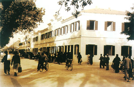
Building on the Avenida Almirante Lacerda. 1950's.
Photo: archive of the Review of Culture.
The islanders paid an annual voluntary contribution for improvement of the townships, sometimes also making special donations for a specific purpose. From 1873 this process was replaced by regular taxes, which allowed the planning of new works, such as public buildings, gardens etc.
The devastating typhoon of 1874 flattened the villages and caused the loss of hundreds of lives, along with innumerable boats which were the principal livelihood of the inhabitants and, in many cases, also their home. This led to not only reconstruction work but also the building of new houses.
Because the São Rafael Hospital was stretched to its limits and began to turn away patients coming from the islands, it was resolved in 1875, at the initiative of Governor Lobo d'Ávila, to build a hospital on a hill on Taipa. To achieve this end, a fund-raising drive was launched throughout the territory, to supplement the Government's contribution. The Public Works Department carried out the project under the direction of the commander of the fort. The hospital had small wards with two beds, premises for mental patients, and, in the centre, a Chinese temple. However, once it was completed, the Chinese residents showed no interest in it and did not use it. It was, therefore, as of 1876, used as a barracks for the Taipa regiment. After the great typhoon of 1883, when it was badly damaged, it was handed over to the Exchequer, thus becoming government property. In 1965 the Social Rehabilitation Centre was installed there after the necessary restoration and modification work was completed.
In 1875 the inhabitants of Taipa built in the village a house which was intended to be a hospital, but which came to be used as a prison. It was only in 1958 that a medical post was established on Taipa, and this is still functioning.
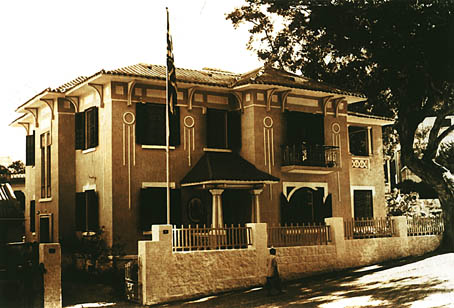
The British Embassy Building in Macao (1958). Calçada do Paiol/Calçada do Gaio:
Photo: archive of the Review of Culture.
In 1875, the military commander of Taipa informed the government of the need to build a chapel on each island. However, it was only on Taipa that this came to fruition, with the approval of the government and the bishopric and according to the plans drawn up by the Public Works Department, carried out in 1882. The church, situated on a small elevation in the centre of the village, was dedicated to Nossa Senhora do Monte do Carmo (Our Lady of the Carmo Hill), and the rectory was annexed to it.
In 1878, in order to facilitate the census, a survey was made of the number of houses in each - village and the names of the respective street plans. This means that we know how many villages there were then on the islands. Taipa Island had the village of Taipa, Sam-cha-chin, Lam-cha-chin, Seong-sa, Chioc-cha-chin and Sei-sai, while Coloane had the villages Lai-chi-uan, Tai-uan, Seac-pai-Uan and Kau-hou.
A large part of Taipa village was once again destroyed by fire in 1878. The site was razed, and, the following year, a market was built there. Subsequently, certain roads were paved and trees were planted along them, and a site was chosen for a cemetery. Governor Corrêa da Silva, on visiting the township after the disaster, decided that a wide road should replace the narrow streets which had previously been there. Fire services were only regulated on the islands in 1883.
Tree planting in Taipa and the creation of nurseries for this purpose were proposed in 1882 and begun the following year, thus providing the lovely green cover on the island which is still evident today.
In 1882, two Chinese schools were established, one on Coloane and the other on Taipa (the latter in the precinct of the T'in Hau Miu). The first Portuguese school was in the residence of the parish priest, Estevão Eusébio Situ, and run by him, from 1891 onwards. Four years later, the Canossians founded an asylum for orphaned and abandoned children. In 1901 they took charge of a boys' school for children from the Asilo da Sta Infância, in Macao. Along with other orders, they were expelled from the territory in 1910, and the children were transferred to other schools.
In 1911 on Taipa there was a secular girls' school, a boys' school financed from the administration of Mission funds and another boys' school run as a dependency of the church, with one teacher. These schools later merged, forming the D. João Paulino School, which in 1967 transferred to purpose-built premises and was annexed to the Nossa Senhora do Carmo Nursery Centre, both of which were entrusted to the Franciscan Missionaries of Mary. These two schools provided pre-school and primary education. In 1958, the João de Deus Luso-Chinese Primary School was set up, which currently offers both pre-school and primary education, both of which are also provided by the Fong Chong School in the village of Taipa.
A telegraph system was established between the islands and the peninsula in 1884, at which date daily delivery of mail by packet boat became regular. It was only in 1954 that postal services were installed in their own buildings, designed by engineer Humberto Rodrigues.
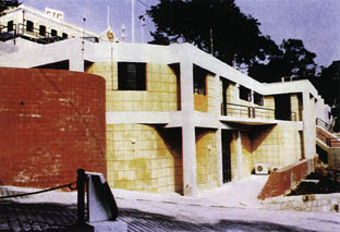
Post for the National Guard - Eduardo Flores.
Occupation of the islands could not be intensive, given their distance from the peninsula which could be reached only by packet boats or fishing vessels. Only in 1974 was the Governor Nobre de Carvalho bridge opened. It was designed by Edgar Cardoso and provided a link not only to Taipa, but also to Coloane, via the isthmus finished in 1968. The bridge, which took five years to build, is around 3,450 meters long with two roadways, one in each direction, and is notable for its shape: a dragon with its back arched. With the opening of the bridge to motor traffic, the development of the islands began, accompanying that of the city.
An urban development plan was drawn up in 1982 for the south coast of Taipa Pequena, entitled "Gardens of Lisbon" and covering an area of 4.38 hectares. This plan was concerned to maintain, wherever possible, environmental characteristics, namely, the ridge with its fine vegetation. A residential area with provision for 500 homes was considered, as well as a shopping centre, a hotel and a private club. Building was integrated into the landscape by means of "cascade" occupation, descending the hillside. This design was drawn up by Urbis Design Group, in collaboration with architect José Floriano Pereira Chan.
In 1984, the China Fujian Corporation, in collaboration with the same architect, presented a new design proposal taking into account the soil characteristics. Although the project obviously entailed great alterations to the scenery, there was an attempt to protect the environment, using a system of platforms linked to an adequate landscape treatment.
This solution was revised in 1987 in order to increase parking spaces, and again in 1988 to take account of geomorphological factors, since there had been several cave-ins that necessitated consolidation work. The positioning of the shopping centre and the car park were altered, along with the greater part of the residential blocks, with the intention of rationalising the use of space using fewer buildings with greater volume measurements, increasing them from 9 to 15 storeys. As is usually the case, the best intentions of the plan are not being followed in the work. However, this plan was maintained in the "General Plan of Taipa."
At the end of 1988, the firm Asia Consult presented a proposal for the draft of the "General Plan of Taipa" based on the existing land registry of the island and bearing in mind existing plans and projects.
Obviously, any development study for Taipa depends upon its inter-linking with the surrounding urban development, especially with respect to the road system. Another important aspect of planning involves the location and dimensions of land reclamation projects.
This plan began with the provision of a new Macao-Taipa bridge, to be built from the passenger terminal of the Outer Harbour to the western extremity of the Pac On land-fill. From this was derived the road layout of the island, also in accordance with a new link to Coloane, to the east of the present isthmus.
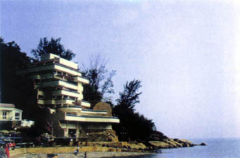
Residence in Coloane - Eduardo Lima Soares.
Three areas of urban expansion were proposed: the hillsides of Taipa Grande and Taipa Pequena, the area between the Estrada Marques Esparteiro and Pac On beach, and the reclamations by the airport, according to the most recent version of the Master Plan for the Macao Airport. The need for more reclamation between the islands, in the bay of Nossa Senhora da Esperança, was also foreseen.
Noise from the airport constrained land use, bearing in mind how the transmission of sound waves and the corresponding restrictions influence the various possible end uses.
Another plan, New Taipa, was presented by SOMEC in 1987, and has since undergone various alterations.
COLOANE
Coloane, or Ko-Lo-Wan (meaning bay of passage) is the most distant island from the Peninsula of Macao.
Archaeological remains found on the island by a group of archaeologists from Hong Kong provide evidence that Coloane was already inhabited around 4,000 years ago. However, its recent history only began in the last century: it was occupied in 1851 and a military base was established in 1864 at the request of its inhabitants. This was later followed by the construction of a coastal fortification in 1884 to meet the further demands of local residents who wished to be defended from the pirates. It was a simple battery situated on the western coast in front of the island of Montanha, which controlled shipping in the channel between the two islands. Consisting of an esplanade in the shape of a half-hexagon, it comprised only a look-out post and a buried munitions depot.
At that time there was already a temple, the Tin Hau Ku Miu, built in 1736 and dedicated to the "Queen of the Sky." It is situated to the south-east of the island, on a spot which was then considered to be auspicious, called "the fisherman throws his net." However, nowadays it is in an abandoned state.
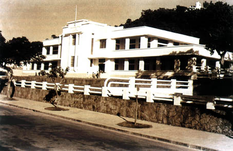
Sir Robert Ho Tung Official Primary School. Around 1950. Photo: archive of the Review of Culture.
The other temples of the village date from the 19th century, between 1862 and 1865: Kun Yam Miu, in the Rua Central, Tam Sin Seng Miu, in the Rua 5 de Outubro and Sam Seng Kong, in the Rua dos Barqueiros. All are part of the "Four Pagoda Association", a charitable organisation. Outside of the village there are also the temples of Sam Sing (the three seers), in Ka-H6, Si Fu (master), in Seak Pai Van, and that of the great king in Hac-Sá.
A great fire on Christmas Eve 1864 completely destroyed the village of Coloane, which in little more than a year was completely re-built this time with well-levelled and illuminated roads.
In 1867 plans for a government building were approved, and the following year the Exchequer Services were installed there. With the bricks and wood left over from the demolition of the old building, two houses were built, which demonstrates the shortage of building materials on the island.
The Police Station and the Coloane quay underwent improvement work in 1873, and the following year the projects for a new quay and Post for the National Guard were approved.
In 1882, tree-planting was begun on the island. In the same year, the Loucanes Barracks was built and the village's streets were paved. The market was built in 1893 and inaugurated by Governor Borja, after whom it was named. Also in 1893, a by-law was published in the Official Gazette on building and reconstruction of houses on the island.
The first school of the islands was opened on Coloane in 1882. It was for Chinese children since there were no Portuguese there because of the distance from the city. A Cantonese-medium boys' school functioned in a rented house between 1915 and 1924. In 1916 a municipal school was founded in Ká-Hó.
The project for the S. Francisco Xavier School was approved in 1927, and it opened the following year. In 1959 a new boys' school opened, and in 1974, the diocese built a two-storey building for a technical school on the site of the St. Francis Xavier Mission. This school was later transformed into the Educational Institute for Minors (Instituto Educacional de Menores), run by the Salesians.
There are currently five schools on Coloane: the Hac-Sá School, for pre-school and special education, the Comandante Gabriel Teixeira Luso-Chinese Primary School, founded in 1958 and providing pre-school and primary education, the D. Luís Versíglia School, which only provides primary education, the Sagrado Coração de Maria School, opened in 1957 and run by the Canossian Sisters, which provides pre-school and primary education, as does the São José de Ka-Ho School, founded in 1974 and belonging to the Don Bosco Volunteers, who already had a training centre and a day-care center for abandoned children, built in 1971 in Ka-Ho.
The S. Francisco Xavier Church was built in 1928, next to the existing school. A monument to the "1910 skirmich of Coloane" was erected in the garden in front of the church. In the centre of village there is another garden, next to the market. Close by is the Post Office building, the library and the Central Prison of Macao.
In 1968 the land link between Taipa and Coloane was opened, which, together with the building of the Macao-Taipa bridge in 1971, led to the development of the island. Its beaches, Hac-Sá and Cheoc Van, began to be used by both city dwellers and islanders, and new buildings appeared there. The police force installed a bathing colony in Hac-Sá, which has a restaurant close by. A short distance away, there is a sport and leisure complex with gardens, swimming pool and bar, which belongs to the islands' Town Hall. In Cheoc Van there is a Pousada (state-owned, country-house hotel), various homes and the club house of the Clube Náutico. Urban development is also underway on the hillside.
CONSTRUCTION
EARLY BUILDING
Obviously, building methods have developed since the Portuguese arrived in the peninsula. Early dwellings must have had structures of bamboo or tree trunks, walls of woven matting and a straw roof, preceding or co-existing with houses made of wooden boards, a typical way of building that utilised the good quality wood which was then plentiful in the region.
Part of the population - fishermen and river boatmen - lived on their own boats. Initially these would without doubt have been simple junks made of bamboo, later evolving into vessels of various types, built of good quality wood such as teak, camphor and oak. The sails would originally have been of woven matting, later of canvas or sailcloth.
Bamboo (choc) is a characteristic grass of China, and a constant motif in Chinese painting throughout the ages. It was used for the most diverse purposes, from foundations to roofs and the woven mats which so often were used for walls or roofing. On the boats, the yards, masts, ropes, rigging and sails could all be made of bamboo. Venceslau de Morais said: "if rice is the bread of China, bamboo is everything else. It is the houses, it is the wood for building, it is the yards of the boats, it is the rope for domestic implements, it is the furniture and also the food.." Even today it is widely used for scaffolding and furniture and various utensils, as well as for making paper, in farming, in cooking and as a medicine.
For building temples, brick, wood and granite were used, along with the beautiful green glazed roof tiles, and the eaves were finished off with carved rounded elements. Wooden or stone ridges, with their strange forms, overlaid the curved roofs. It was in the temples that the best wood was used, such as chi quiong moc for the roofing timbers and the columns, or the extremely expensive sun chi moc or tamarind for the doors and windows.
Later on, lath-and-plaster, or "chunambo" (nai ch'eong) began to be used, which consisted of a mixture of earth, straw and lime made from oyster shells, with wooden posts inserted to give cohesion, the various layers being pounded down one after the other. This brownish material was extremely resistant, and was mainly used for defensive walls.
Oyster shells also provide an excellent quality snow-white lime which was often used in whitewash. For some time they were also used in windows, since thin flakes of the shells provided a soft light to the interior.
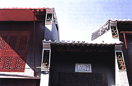
Rua da Felicidade, restored. Photo by Joaquim de Castro.
WOOD
The cheapest wood - and therefore the most common for building - was pine, in one or other of its seven varieties: sai kong cham, tung kong cham mok, lau chau cham mok and pak kong cham mok - the latter being a little more expensive. It was "multi-purpose wood", used for beams and floors, doors, windows and roof trusses.
For the same purposes there was also iau sau mok, which was more expensive since it came from Singapore.
For the rafters, hong sau mok, hac sau mok, cheng sau mok and sun mui kak mok, (in increasing order of expense) were used, or even molave, or loi song kak mok, with which the floors, staircases, doors and windows were made in houses whose builder could afford to be more extravagant.
For flooring, again by order of their expense, chow chap mok, cam pat mok, pak sau mok, ma mei chong mok and iau mok or teak were used, this last costing around double the price of the others; but even so, it was still less than half the price of molave.
The roof boards were made of chow chap mok, cam pat mok, pak sau mok, thit sau mok, cai ngho kak mok, or, for the more well-to-do, kwan liu kak mok. The ridge pole could be of an even more expensive quality, kat li long mok. On the roof trusses were laid battens of a circular section, conserving the rounded form of the tree trunks. The roof tiles sat on the trusses and their respective battens.
The doors and windows generally had a stone surround and their frames were normally of hong sau mok. The actual doors and windows themselves were generally made of wood of such diverse quality that the price of the more expensive could be around four times that of the cheapest: pa ma chow mok, chow chap mok, cam pat mok, pak sau mok, cai ngho kak mok, tong kweng kak mok, pon ti fa li mok, iau mok, or teak, pak fa li mok, hong fa li mok or manil padauk, loi song fa li mok, and the expensive molave, loi song kak mok.
In spite of its wide use in architecture, wood was nevertheless rarely used for a simple post and beam frames as in China, for fear of typhoons. Therefore, free-standing walls were pinned with wooden beams at short intervals. The size of the available timber determined the position of the walls and thereby the width of the internal divisions. In order to build larger spaces, such as vestibules and large rooms, wide beams were used close together and firmly pinned.
The characteristics of the most common types of wood are as follows:
Pine is a light wood, with no knots, easy to work, soft, attractive and long-lasting. There are expensive varieties, which were correspondingly less often used, and cheaper varieties, which were used for rafters, floors, doors, windows and roof trusses.
Teak is solid, of a dark yellow colour, which is non-porous and polishes well. It was used for floors, doors and windows. It was preferable to any other wood because it is hard-wearing and resistant to termites.
Manil padauk (pterocarpus indicus) has three varieties, coming from Siam, Manila and Canton. The first of these is of a reddish tone and the others are yellowish. It is a solid wood which polishes well and was often used in the staircases of the best houses, as well as for doors, windows and carvings.
Tamarind is a solid reddish wood which polishes well. It was little used due to its high price, mainly being found in the doors and windows of Chinese temples.
Molave, which come from Manila, was perhaps the most expensive wood, and was therefore only used in the houses of the most well-to-do families, for rafters, floors, doors and windows. It is solid and of a yellow tinge, polishes well and is long-lasting.
OTHER MATERIALS
Grey bricks were soft bricks made from a fine clay from Southern China. Vetch was used in their manufacture, and its sap contributed to binding the mix, resulting in a tough and long-lasting material. The bricks were well-baked, with a clear metallic tinge, and measuring about 52 x 35.5 x 7.5 cm. They were fired in charcoal ovens and sometimes the manufacturer would stamp them with his own mark. For a long time these bricks were the most widely used building material, only being dethroned by the present day red brick, which is also a soft brick.
Stone was only infrequently used for houses, and then only for the foundations, on which were built brick or lath-and-plaster walls. There was very good quality granite, and also marble, which was generally reserved for interiors. These kinds of stone were used for religious or civic buildings, sometimes carved, for columns, door mouldings and figurative panels.
Glazed tiles, which would be extremely useful in this damp climate, were rarely used due to their high price as a result of being imported from Portugal. They were only used for fascias under the eaves of the roofs or, inside buildings, as wainscoting in the main divisions.
The material used for plastering or rendering was cheap and widely used even in cheaper buildings.
Under the eaves of the roofs, there were often panels of figures moulded in terracotta and painted in bright colours. The drainpipes were also made of terracotta, around 10cm. in diameter and in sections of between 70cms. and 1 meter long. They were moulded on the outside to imitate pieces of bamboo.
The roof tiles, also of terracotta and sometimes glazed, were laid in alternate rows, of square, flat, slightly overlapped tiles and curved tiles which were cemented to each other and to the plain tiles. The eaves were usually finished with a smooth surface at the edge of the curved roof tiles, with decoration in bas-relief.
Cement only began to be used from 1886, at which time a cement factory was set up on the Ilha Verde isthmus by the Englishman Creasy Ewens. It made Portland cement, which, due to its high quality, came to be used throughout all of the East, from Australia to Japan. The materials used for its fabrication were limestone, from a vast deposit in Guangdong province and the mud taken from the Inner Harbour at low tide. The stone, containing around 93 per cent lime carbonate and 7 per cent magnesium carbonate, was reduced to powder with the mud, with 12 per cent water being added. Bricks were made from this paste, dried in the sun and then fired in special ovens running on coke brought from Japan. These bricks were then pulverised in specialised mills which reduced them to a very fine powder, indicative of its high quality.
Nowadays, construction uses reinforced concrete, supported by piles many meters deep. The walls are of brick, ten centimetres wide. Work progresses rapidly, and, if the finishings are not of great quality, at least the structures are solid. Between the first act of the builder, for example, deciding to erect a 30 or 40 storey building, and the viewing of the same building by prospective tenants, very little time passes, given that the project is, in the majority of cases, quickly approved. In this way, the great building boom which we are currently experiencing can be understood.
To complement this civil construction boom, public facilities are also being built, in both the administrative and technical areas. The CEM building, in the Estrada D. Maria Ⅱ, houses the Directorates for Land and Urban Planning, Public Works and Transport, Cartography and Land Registry, and part of the Directorate for Civil Service Support. In front of the São Francisco Garden is the Directorate of Education, while there is a new Health Centre in Tap Seac. As well as the other technical installations previously mentioned, there is a new electric power station operating on Coloane which will serve the whole territory.
Translated from Portuguese by PHILOS - Comunicação Global, Lda. www.philos.pt
I-BIBLIOGRAPHY
AMARO, Fernando da Silva. "Achegas para a Reconstituição Histórica da Fábrica de S. Paulo" (Contributions towards the Historical Reconstitution of the Fábrica de S. Paulo) in Boletim Eclesiástico da Diocese de Macau (Ecclesiastic Bulletin of the Diocese of Macao).
BASTO DA SILVA, Beatriz. Elementos da História de Macau. (Elements of the History of Macao) Direcção dos Serviços de Educação e Juventude. 1998.
BELTRÃO COELHO, Rogério. Álbum Macau (Album of Macao)-1844-1974. Fundação Oriente. 1989.
_____Macau - Selos, Uma Forma de Expressão. (Macao - Stamps, a Form of Expression) Direcção dos Serviços de Correios e Telecomunicações de Macau. 1986.
BOXER, Charles R. A derrota dos Holandeses em Macau no Ano de 1622 (The Dutch Defeat in Macao in 1622).
_____"Dares-e-Tomares nas Relações Luso-Chineses Durante os Séculos ⅩⅦ e ⅩⅧ Através de Macau". (Mutual Influences in Portuguese and Chinese Relations in the 17th and 18th centuries). Separata dos Arquivos de Macau (Sep. of the Archives of Macao).
_____ Fidalgos no Extremo Oriente - 1550-1770 (Fidalgos in the Far East - 1550. 1770). Fundação Oriente/Museu e Centro de Estudos Marítimos de Macau. 1990.
_____ O Grande Navio de Amacau (The Great Ship of Amacau). Fundação Oriente/Museu e Centro de Estudos Marítimos de Macau. 1989.
BRAGA, José Maria. Os tesouros do Colégio de S. Paulo (The treasures of the Colégio de S. Paulo).
BRIGGS, Tom e Crisswell, Colin, "Old Macau". South China Morning Post Ltd. 1984.
COLOMBAN, Eudore de. Resumo da Historia de Macau. (An Abstract of the History of Macao), Dated 1923. Re-issued in 1980.
CREMER, R. D. Macau - City of Commerce and Culture.
ESTÁCIO, António J. Emerenciano. Dinâmica das Zonas Verdes da Cidade de Macau (Dynamics of the Green Areas of the City of Macao). Serviços Florestais e Agrícolas de Macau. 1982. FIGUEIRA, Francisco e TENREIRO, Adalberto (orgs.). Macau 76/78 - Arquitectura Contemporânea (Macao 76/78 - Contemporary Architecture) Instituto Cultural de Macau. 1986.
GRAÇA, Jorge. Fortificações de Macau (Fortifications in Macao). Instituto Cultural de Macau. 1986.
Historic Chinese Architecture. Compiled by the Dept. of Architecture, Qinghua University. 1985.
LESSA, Almerindo. A História e os Homens da Primeira República Democrática do Oriente (The History and the Men of the First Democratic Republic in the East)
MARIA, José de Jesus, br. Ásia Sínica e Japónica (Chinese and Japanese Asia). Instituto Cultural de Macau/Centro de Estudos Marítimos de Macau. 1988.
MONTALTO de Jesus, C. A. Macau Histórico (Historic Macao). Livros do Oriente. 1990.
PEREIRA, J. F. Marques (Co-ordinator). Ta-Ssi-Yang-Kuo: Arquivos e Anais do Extremo Oriente Português 1889-1990 (Ta-Ssi-Yang-Kuo - Archives and Historical Records of the Portuguese Far East) -. Series I and Ⅱ. Direcção dos Serviços de Educação e Cultura/Arquivo Histórico de Macau. 1984.
SANTOS, C. Pinto dos e NEVES, Orlando. De Longe à China (From Afar to China). Volumes I and Ⅱ. Instituto Cultural de Macau. 1988.
SMIRNOFF, George Vitalievich. Macau Anos 40 (Macao in the 1940s). Leal Senado de Macau/Museu Luís de Camões.
TCHEONG-U-LÂM and IAN-KUONG-IÂM. Ou Mun Kei Leok (Monografia de Macau) (Monograph on Macao) Quinzena de Macau. 1979.
TEIXEIRA, Manuel. Pagodes de Macau (Pagodas of Macao). Direcção dos Serviços de Educação e Cultura. 1982
_____ Primórdios de Macau (The beginnings of Macao). Instituto Cultural de Macau. 1990.
_____ Cem Anos da Vida do Quartel dos Mouros 1874-1974 (One Hundred Years of the History of the Moorish Barracks). Imprensa Nacional. 1974.
_____ Clube Militar de Macau (Macao Military Club) 1982.
_____ A Educação em Macau (Education in Macao). Direcção dos Serviços de Educação e Cultura. 1982.
_____ A Fachada de S. Paulo (The Façade of S. Paulo). Imprensa Oficial de Macau.
_____ Liceu de Macau (The Liceu of Macao). Direcção dos Serviços de Educação. 1986.
_____ Macau no Século ⅩⅥ. (Macao in the 16th Century) Direcção dos Serviços de Educação e Cultura. 1981.
_____ Macau no Século ⅩⅦ. (Macao in the 17th Century) Direcção dos Serviços de Educação e Cultura. 1982.
_____ Macau no Século ⅩⅧ (Macao in the 18th Century). Imprensa Nacional. 1984.
_____ Toponímia de Macau (Macao Toponymy). Volumes I and Ⅱ. Imprensa Nacional. 1981.
_____ A Voz das Pedras (The Voice of Stones). Imprensa Nacional. 1980.
WOJTOWITCZ, Jerzy and HAIGH, Diane. Cartilha para Coloane (Elementary Treatise on Coloane). Instituto Cultural de Macau. 1990.
WONG, Shiu Kuan. Macao Architecture: An Integrate of Chinese and Portuguese Influences. Department of Architecture, Hong Kong University. 1968-69.
VIDEIRA PIRES, Benjamin, S. J. Os Extremos Conciliam-se (The Meeting of Extremes). Instituto Cultural de Macau. 1988.
_____ A Viagem de Comércio Macau-Manila nos Séculos ⅩⅥ e ⅪⅩ (The Trade Route from Macao to Manila in the 16th and 19th centuries). Centro de Estudos Marítimos de Macau. 1987.
_____ Antigos Navegadores e Marinheiros Ilustres nos Monumentos e Toponímia de Macau (Famous Navigators and Sailors Commemorated in Monuments and Toponymy of Macao). Obra Social dos Serviços de Marinha. 1984.
Ⅱ- PERIODICALS
Arquivos de Macau (Archives of Macao). Arquivo Histórico de Macau.
Boletins Oficiais (Official Gazettes).
Building Journal. Hong Kong. 1989.
* Course in Architecture from the Escola Superior de Belas Artes (School of Fine Arts) in Lisbon (1961). Architect for the Town Planning Services of the S. O. P. of Angola (1963), and the Câmara Municipal de Lisboa (Lisbon City Council) (1971). She lived in Macao, where she was an architect in the DSSOPT, a researcher on architectural history in Macao and the recipient of an ICM grant.
start p. 13
end p.